Satellite-borne laser near-coast terrain detection laser radar and detection method

A laser radar, terrain detection technology, applied in radio wave measurement systems, instruments, etc., to achieve the effects of strong seawater penetration, fast measurement speed, major military and economic benefits

Pending Publication Date: 2021-03-19
BEIJING RES INST OF TELEMETRY +1
View PDF0 Cites 6 Cited by
  • Summary
  • Abstract
  • Description
  • Claims
  • Application Information

AI Technical Summary

Problems solved by technology

[0006] Domestically, a lot of research work has been carried out on the development of laser radar and the research on the use of laser radar in the field of ocean detection. However, due to various reasons such as technical maturity, there is currently no use of multi-beam, dual-wavelength large-scale LiDAR satellite payload reporting dedicated to oceanographic mapping launched by energy lasers

Method used


Image

  • Satellite-borne laser near-coast terrain detection laser radar and detection method
  • Satellite-borne laser near-coast terrain detection laser radar and detection method
  • Satellite-borne laser near-coast terrain detection laser radar and detection method

Examples


Embodiment Construction

[0046] The following describes the present invention in detail, and the features and advantages of the present invention will become more clear and definite along with these descriptions.

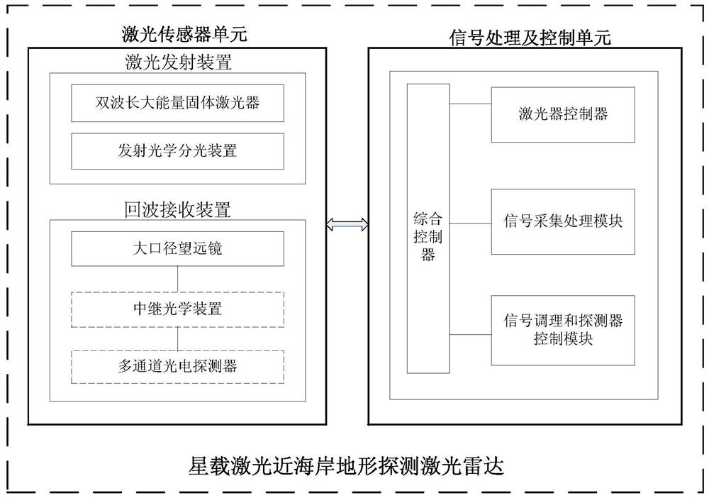
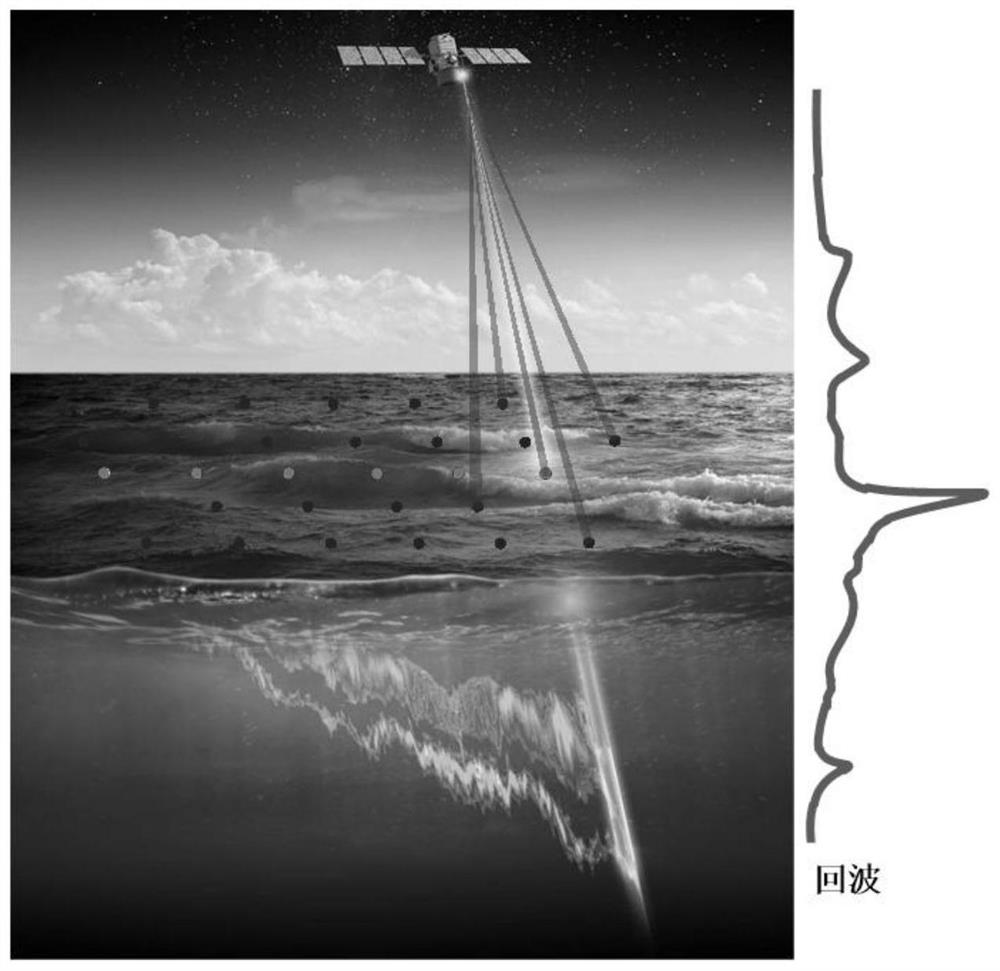
[0047] According to a first aspect of the present invention, a spaceborne laser near-coast terrain detection lidar is provided, such as figure 1 As shown, it includes a laser sensor unit and a signal processing and control unit, and the laser sensor unit includes a laser emitting device and an echo receiving device, wherein,

[0048] Laser emitters include:

[0049] Laser, used to generate 532nm, 1064nm dual-wavelength laser under the control of the laser controller;

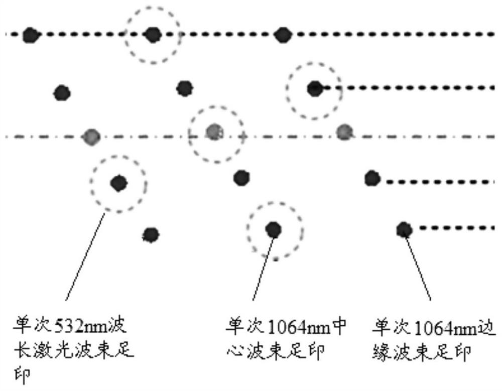
[0050] Transmitting optical splitting device, used to separate the dual-wavelength laser beams output by the laser, to generate 5 beams of 1064nm wavelength laser beams, 1 beam of 532nm wavelength laser beams, of which 1 beam of 1064nm wavelength laser beams is used as the center beam and 532nm wavelength laser beams The la...


PUM


Abstract

The invention provides a satellite-borne laser near-coast terrain detection laser radar and a detection method. The satellite-borne laser near-coast terrain detection laser radar comprises a laser, atransmitting optical light splitting device, a large-aperture telescope, a relay optical device, a multi-channel photoelectric detector, a laser controller, a signal acquisition and processing module,a signal conditioning and detector control module and a comprehensive controller. Parallel dual-wavelength laser emission is utilized, large dynamic detection of deep sea and shallow sea seabed echoes is achieved through large and small view field detection of 532 nm wavelength laser echoes, synchronous detection of the sea surface is achieved through 1064 nm echo detection, and therefore the near-coast seabed terrain and a water depth are accurately measured; atmospheric detection is realized through parallel dual-wavelength laser emission and polarization receiving detection; and through multi-beam laser emission and sub-view-field receiving detection, high-efficiency measurement of an ocean wave height and the near-coast land terrain is achieved, the laser radar is carried by a satellite platform, and global-scale near-coast terrain and water depth measurement can be achieved through continuous scanning in a satellite flight direction.

Description

technical field [0001] The invention belongs to the technical field of terrain detection, and in particular relates to a spaceborne laser near-coast terrain detection laser radar and detection method, which is suitable for quantitative measurement of near-coast terrain, shallow sea topography and water depth on a global scale, and takes into account shallow sea water profile and atmospheric detection . Background technique [0002] Marine basic surveying and mapping mainly consists of two parts: bathymetry and coastal topographic survey. Coastal topography is an important part of coastal charts, including land topography above the coastline, tidal flat topography and shallow water underwater topography. The ship navigation process not only depends on the water depth information in the sea chart, but also needs to combine the coastal and island land information to better optimize the route and realize the ship navigation and positioning. Landing operations rely heavily on c...

Claims


Application Information

Patent Timeline
Patent Type & Authority Applications(China)
IPC IPC(8): G01S7/481G01S7/4861G01S7/4913
CPCG01S7/481G01S7/4814G01S7/4816G01S7/4861G01S7/4913
Inventor 潘超刘宇哲王丽东李菁文韩晓爽边吉李祚涵赵艳赵一鸣于勇李凉海
Owner BEIJING RES INST OF TELEMETRY
Why Eureka
Try Eureka