Air-ground cooperative pesticide application method and system
An air-ground collaborative and ground-based technology, applied in control/regulation systems, instruments, three-dimensional position/channel control, etc., can solve the problems of incomplete coverage of chemical liquid, poor control effect, uneven spraying, etc., and achieve optimal spraying control methods and effect, effective control, and effect of reducing negative impact
Active Publication Date: 2021-06-15
BEIJING RES CENT OF INTELLIGENT EQUIP FOR AGRI
20 Cites 3 Cited by
AI-Extracted Technical Summary
Problems solved by technology
[0005] Aiming at the problems existing in the prior art such as uneven spraying, incomplete coverage of medicinal liquid, serious medicina...
View moreMethod used
The open space cooperative pesticide application method provided by the present invention, according to the characteristic information of orchard and fruit tree, planning cooperative operation path, on this basis, control plant protection unmanned aerial vehicle and ground application unmanned vehicle to carry out by the collaborative operation path of planning Operations, in the form of open-ground collaborative spraying, use the ground spraying unmanned vehicle to supplement the blind area of the plant protection drone operation, realize the full coverage of fruit trees with the liquid medicine, maximize the utilization rate of the medicine, and reduce the cause of unreasonable pesticide spraying. The negative impacts of the fruit trees can be reduced, environmental pollution can be reduced, and the control method and effect of spraying can be optimized, so that the pests and diseases of fruit trees have been effectively controlled, and the stable and increased production of fruits can be effectively guaranteed.
The open space cooperative pesticide application system provided by the present invention, according to the characteristic information of orchard and fruit tree, plans cooperative operation path, on this basis, control plant protection unmanned aerial vehicle and ground application unmanned vehicle to carry out by the coordinated operation path of planning Operations, in the form of open-ground collaborative spraying, use the ground spraying unmanned vehicle to supplement the blind area of the plant protection drone operation, realize the full coverage of fruit trees with the liquid medicine, maximize the utilization rate of the medicine, and reduce the cause of unreasonable pesticide spraying. The negative impacts of the fruit trees can be reduced, environmental pollution can be reduced, and the control method and effect of spraying can be optimized, so that the pests and diseases of fruit trees have been effectively controlled, and the stable and increased production of fruits can be effectively guaranteed.
The present embodiment passes the drift information that sensor is collected to control station, and then draws medicinal liquid in fruit tree canopy drift range, by carrying out corresponding angle of application to the application angle of unmanned vehicle spraying arm of ground application Adjust to make up for the drift of the plant protection drone's spraying to achieve full coverage of the spraying, to achieve uniformity of the fruit tree control liquid, and finally to achieve precise spraying of the fruit trees in the orchard.
The present embodiment...
View moreAbstract
The invention provides an air-ground cooperative pesticide application method and system. The method comprises the steps that: target information of a to-be-operated orchard is obtained, wherein the target information includes geographic feature information and fruit tree feature information; according to the target information, a collaborative operation path of a plant protection unmanned aerial vehicle and a ground pesticide application unmanned vehicle is determined; and the plant protection unmanned aerial vehicle and the ground pesticide application unmanned vehicle are controlled to operate according to the collaborative operation path. According to the air-ground cooperative pesticide application method and system of the invention, the collaborative operation path is planned according to the feature information of orchards and fruit trees; on this basis, the plant protection unmanned aerial vehicle and the ground pesticide application unmanned vehicle are controlled to operate according to the planned collaborative operation path; the ground pesticide application unmanned vehicle is utilized to perform supplementary operation on an operation blind area of the plant protection unmanned aerial vehicle in an air-ground collaborative pesticide spraying mode, and therefore, pesticide liquid can fully cover the fruit trees, the pesticide utilization rate is improved to the maximum extent, negative effects caused by unreasonable pesticide spraying are reduced, environmental pollution is reduced, the pesticide spraying control mode and effect are optimized, fruit tree diseases and insect pests are effectively prevented and treated, and stable yield and yield increase of fruits can be effectively guaranteed.
Application Domain
Technology Topic
Image
Examples
- Experimental program(1)
Example Embodiment
[0034] In order to make the objects, technical solutions, and advantages of the present invention, the technical solutions in the present invention will be described in connection with the drawings of the present invention, and it will be described, and , Not all of the embodiments. Based on the embodiments of the present invention, those of ordinary skill in the art will belong to the scope of the present invention without all other embodiments obtained without creative labor.
[0035] It should be noted that in the description of the embodiments of the present invention, the terms "comprising", "comprising" or any other variable admissibility is intended to cover non-exclusive contained comprising a series of elements, methods, articles, or equipment Not only are those elements, but also other elements that are not explicitly listed, or include elements inherent to such processes, methods, items, or equipment. In the absence of more restrictions, the elements defined by the statement "include a ..." and do not exclude additional same elements in the process, method, item, or device including the element. The orientation or positional relationship of the term "upper", "lower" or the like is based on the orientation or positional relationship shown in the drawings, is merely described in order to facilitate the description of the present invention, rather than indicating or implying that the device or component must be It has a specific orientation to construct and operate in a specific orientation, so that it is not understood to limit the invention. The term "installation", "connected", "connection", unless otherwise specified, "Connect", "Connect",,,, It is also possible to be electrically connected; it can be directly connected, or the intermediate medium can be indirectly connected, and can be in the interior of the two elements. For those skilled in the art, the specific meaning of the above terms can be understood in terms of specific cases.
[0036] Bonded below Figure 1 to 8 A method and system for air-collaborative apparatus and system provided by the embodiment of the present invention are described.
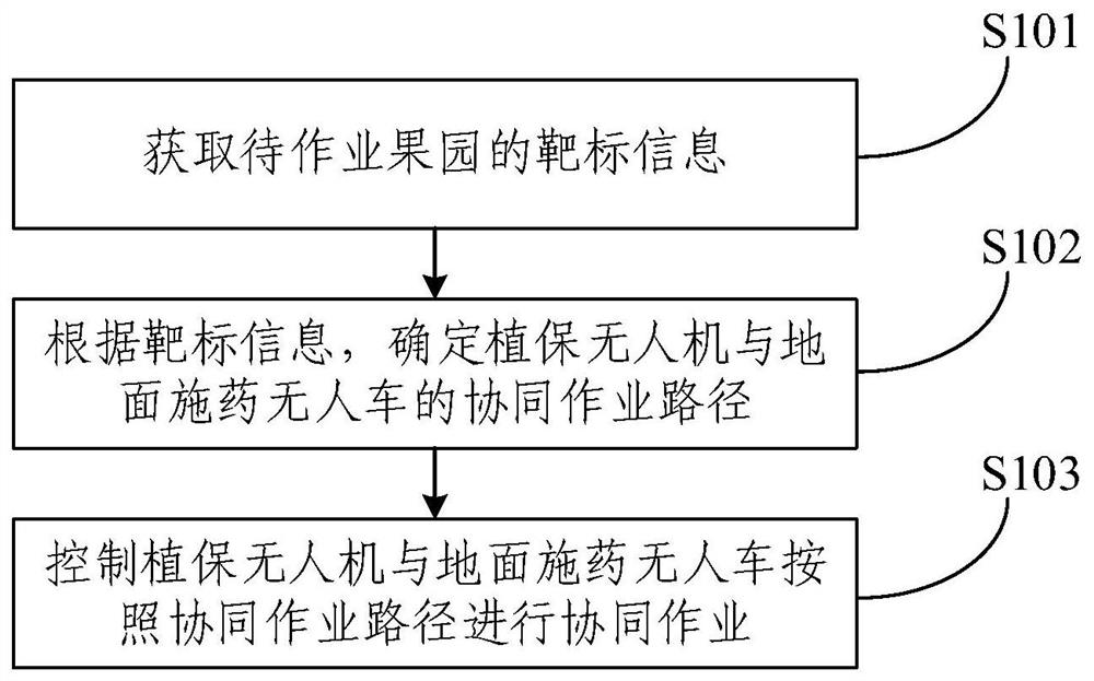
[0037] figure 1 One of the flow schematic of the method of airborne coordination applying the empty land provided by the present invention, such as figure 1 As shown, mainly, but not limited to the following steps:
[0038] S101, get target information of the orchard to be horn, and the target information includes geographic feature information and fruit tree feature information;
[0039] S102, according to target information, determine the synergistic operation path of plant protection drones and ground application drones;
[0040] S103, control plant protection drones and ground application drones in collaborative operations according to the synergistic operation path.
[0041] First, use the positioning system on the plant protection drone to locate the orchard, and take the job orchard to take a scan shooting through the image acquisition device to obtain remote sensing images and three-dimensional point cloud images of the orchard. Among them, the geographic feature information of the orchard of the orchard from the remote sensing image can be extracted from the three-dimensional point cloud image, and the fruit tree feature information of the orchard to be operated can be extracted.
[0042] Among them, geographic feature information may include information such as the area, terrain, fruit tree density and orchard information of the orchard information of the orchard information of the orchard. The fruit tree special information can include: the shape of the fruit tree, the size of the size, the volume, and the top of the crown layer and the ground apparer unmanned vehicle spray arm. 0 And other information.
[0043] Alternatively, the plant protection drone is small, strong load capacity, when used in air spraying liquid, high working efficiency, and the down-washing air flow generated by its rotation helps the fluid fog flow to the penetration of fruit trees. Have a good prevention effect.
[0044] Alternatively, the positioning system can be a GPS positioning system, a Beidou system, a Glonass system, or a gallerist satellite navigation system, and in the subsequent embodiment of the present invention, it will be described as an example in which the GPS positioning system is positioned as an example, which is not considered to this The invention is defined.
[0045] Alternatively, the image acquisition device can be an infrared scanner, a line array camera, a depth camera, or a high-spectral camera.
[0046] Further, in step S101, the control station is fused to the remote sensing image, acquires the fusion information image, extracts target information including geographic feature information, and fruit tree feature information.
[0047] Alternatively, after the image stitching method based on the SURF algorithm is extracted, the image registration is performed according to the matching of the feature point, and the image is copied to the specific position of the corresponding image, and the overlapping boundary is degraded. Implement the fusion of remote sensing images and 3D point cloud images.
[0048] Further, in step S102, according to the target information, the work orchard is first treated, and then the path search is performed based on the path search algorithm, determine a walking path to obtain an optimal value of the predetermined performance function, determine the plant protection drone Collaborative work path with ground application drones.
[0049] Among them, three-dimensional modeling is carried out to establish an environment model used to facilitate the path planning of the computer, and the actual physical space is abstracted into an algorithm can handle abstract space, and realize the mutual mapping.
[0050] The search path is not necessarily a feasible path that can walk in a ground application drone, which needs further processing and smooth to make it a practical path.
[0051] Alternatively, the path search algorithm can be a Dijkstra algorithm, a SPFA algorithm, a Bellman-Ford algorithm, a Floyd-Warshall algorithm, or a Johnson algorithm.
[0052] Alternatively, the planning path method can be a geometric method, a unit division method, an artificial field method, a grid method, a digital analysis method.
[0053] Among them, the optimal value obtained for performance functions, its optimal reflection is based on the full operation of the work orchard, ensuring the shortest path of the plant protection drone and the ground application drone, no repetitive operation or omission operation.
[0054] Among them, the underwash gas flow sensor 524 of the ground apparer drone is mounted to the height of the same horizontal plane with the ground apparent drone spray arm.
[0055] Further, in step S103, the control of the plant protection drone and the ground application drone in accordance with the synergistic operation path, the plant protection drone treats the upper part of the fruit trees of the work orchard to apply medicine, the ground application According to the current washing flow intensity, the human car determines the portion of the plant protection drone is not approved, calculates the angle of adjustment of the ground application drone, and supplementing the lower part of the fruit tree crown, realizing the comprehensive liquid Covered fruit trees.
[0056] The air-colonization apparatus for the present invention, according to the characteristic information of the orchard and fruit trees, planning a collaborative operation path, based on this, control the plant protection drone and the ground application drone according to the coordinated work path, The way of spraying in the air, using ground application drones to supplement the plant protection drone operation blind spot, realize the comprehensive cover of the fruit trees, maximize the drug utilization, reduce the negative effects of pesticide spraying Reduce environmental pollution, optimize spray control methods and effects, so that the fruit tree disease is effectively prevented, and it can effectively guarantee the protection of fruit and increase production.
[0057] Based on the content of the above embodiment, the target information of the orchard to be operated is obtained as an alternative embodiment, including: obtaining a remote sensing image containing geographic feature information and a three-dimensional point cloud image including fruit tree feature information; based on multi-cell sensor fusion technology, Fusion of remote sensing images and three-dimensional dot cloud images to obtain target information.
[0058] Alternatively, remote sensing image acquisition devices In addition to visible light cameras, infrared cameras, ultraviolet photographers, in addition to infrared scanners, multi-spectral scanners, microwave radiation and scattermeters, side radar, special imaging, imaging spectrometers, etc.
[0059] Alternatively, the three-dimensional point cloud image acquisition device is a 3D camera, which may be one of a binocular camera, a TOF camera, a RGBD camera.
[0060] Sensor data fusion technology integrates partial data resources distributed in different locations or different types of sensors, using computer technology to analyze it, eliminating redundant and contradictions between multi-sensor information, Complementation, reduce its uncertainty, obtain consistency interpretation and description of the subject, thereby improving system decision, planning, reactivity, and correctness, making the system more fully information. The information fusion appears at different levels, including data layers, feature layer fusion, decision layer fusion.
[0061] The plant protection drone has collected data over the orchard of the orchard, on the one hand, the laser radar carried by the plant protection drone can obtain remote sensing images of the orchard, from the remote sensing image, can extract the area, terrain, fruit tree density and orchard boundary Information and other geographical feature information; on the other hand, 3D causators to be horn in the orchard, which can extract the three-dimensional dot cloud images of the fruit trees to be operated by plant protection drones. From the three-dimensional point cloud image, the shape, size profile, volume, and fruit trees including fruit trees can be extracted. Height difference between the top of the crown and the ground apparent drone spray arm 0 Equisical tree feature information. The control station shares and integrates the plant protection drone remote image and three-dimensional point cloud image, multi-sensor fusion technology acquisition information, and extracts the target information of the orchard to be operated.
[0062] The present embodiment is fused by the acquired image information, acquires target information, according to the size, shape and position of each fruit tree in the target information, and is subsequently assigned to the plant-protecting drone and ground application drone. The amount is provided, and the amount of application time is controlled to the application time of each fruit tree by setting the plant protection drone and the ground apparent drone. It is conducive to the different precipitation of each fruit tree demand.
[0063] Based on the above embodiment, as an alternative embodiment, in the case of synchronous operations with the ground application drone, the plant protection drone and the ground application drone are carried out according to the collaborative operation path. Collaborative homework, including:
[0064] Gets the first height difference between the first threshold height and the height of the ground apparent drones; the first threshold height is the relative height of the position and the ground under the synchronous operation;
[0065] According to the first height difference and the air tree distance, the elevation angle between the ground application drone and the synchronization threshold at the position, as the first angle; the car tree is a ground application drone spray arm Distance between the target tree;
[0066] The first angle is adjusted upward on the basis of the ground application drone on the theoretical spray arm; theoretical spray arm is based on the library function.
[0067] Among them, first set the critical threshold of the water purity stream strength. Judging the fruit tree layers of the plant protection drone can penetrate according to the underlying water purification flow; where the water purification flow intensity is a critical threshold The height of the time position is the interface of the plant protection drone and the ground application drone operation area, thereby determining the application area of the ground application drone.
[0068] Among them, the first threshold height is when the gas flow intensity is currently washed, the gas stream intensity is a critical threshold. The relative height of the location is directly acquired by the ground washing gas flow sensor 524 of the ground apparel.
[0069] Among them, the air tree distance L is directly acquired by the ranging system installed on the ground apparent drone.
[0070] Among them, the theoretical spray arm is set according to the general height of the fruit trees, and human setting is the angle of the spray arm in accordance with the tree of fruit trees (such as pear trees, apple trees, etc.), trees and prevention cycle experience values.
[0071] Among them, the library function is based on the granularity of the granulation of the granularity (such as peach, apple tree), tree, tree age, and prevention cycle.
[0072] Synchronous dynamic mode is the same speed of plant protection drones and ground apparatus drones. By adjusting the airborne sprayed arm angle of the ground application drone, it makes up for the fruit trees and dense plant protection drones Poor problem, realize full coverage of the medicinal fruit tree.
[0073] The ground application drone can measure the drying air flow strength after the plant protection drone passed through the crown, and estimates the dynamic deposition distribution area of the plant protection drone drug solution in the crown. Further, dynamically adjust the surface application drone noius angle.
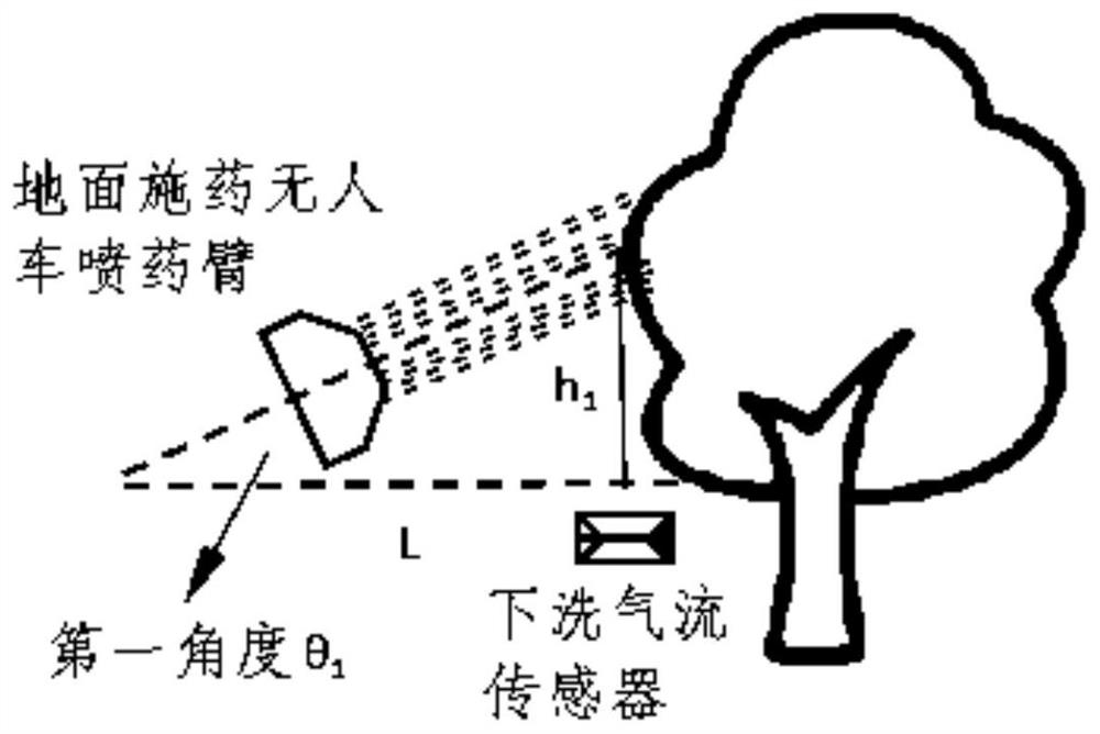
[0074] figure 2 It is a synchronous operation provided by the present invention to adjust the first angle θ upward 1 Dictionary diagram, in one embodiment, such as figure 2 As shown, the plant protection drone will produce the underwash flow, increase the liquid deposition speed, and the underwash gas flow sensor 524 is installed in the same level of the same level of the same level of the same level. Wash flow strength under liquid when Time, Wash the gas stream intensity critical threshold for the underwash gas flow sensor 524 Record the gas stream intensity of the underwater flow rate is critical threshold The high difference between the position between the ground application drone spray arm is the first height difference H 1 , Ground apparer drone apparatus requires coverage to be height below H 1 Target fruit crown, plant protection drone operation sprayed liquid liquid deposition distribution area ψ of the dynamic deposition distribution area of:
[0075] ψ = H 0 -H 1
[0076] The first threshold height is obtained by measuring the gas flow intensity of different heights through the sensor of the ground application.
[0077] The height difference between the water strength and the ground application drone spray arm 1 And the car tree distance L, the first angle θ of the ground apparent drone spray arm needs to be adjusted by the anti-triangle function 1.
[0078] After completing the surface application drone spray arm angle adjustment, the ground application drone and the plant protection drone are synchronized according to the collaborative operation path.
[0079] In this embodiment, the application of the plant protection drone spray arm is adjusted according to the information obtained by the plant protection drone remote sensing image acquisition system, according to the information of the plant protection drone remote sensing image acquisition system. Using ground application drones to supplement the plant protection drone operation blind spot, correct the spray arm angle, and realize the full coverage of the liquid.
[0080] Based on the above embodiment, as an alternative embodiment, in the case of asynchronous operations and ground application drones, the plant protection drone and the ground apparent drone are carried out according to the collaborative operation path. Collaborative homework, including:
[0081] Gets the second height difference between the second threshold height and the height of the ground apparent drones; the second threshold height is the relative height of the position and the ground under the asynchronous operation;
[0082] According to the second height difference and the air tree distance, it is determined that the elevation angle between the ground apparent drone and the lane flow of the water flow under the asynchronous operation is the second angle;
[0083] The second angle is adjusted upward on the basis of the theoretical spray arm angle.
[0084] Among them, asynchronous modeling model plant protection drones and ground application drones are different, and the ground application drone and plant protection drones have their own separate homework.
[0085] Second threshold height h 2 It is a critical threshold when the average value of the plant protection drone is cleaned by the gas stream in the orchard. Time.
[0086] In one embodiment, the plant protection drone and the ground application drone simultaneously, the plant protection drone operation According to the best collaborative operation path generated by the control station, the air operation is carried out in the speed of the ground application drone. , According to the average value of the gas flow intensity under the conventional garden, the ground application drone spray arm is adjusted to the second angle θ on the basis of theoretical spray arm angle. 2 After adjusting the angle in advance, the ground application drone is operated according to the same operation path, and the asynchronous modeling mode is collaboratively operated with the plant protection drone.
[0087] The present embodiment is controlled by controlling the plant protection drone and the ground apparent drone asynchronous operation, and the liquid solution is fully covered with the orchard. This example can make up for the limited defects of the drug-promoting amount of the drug-guarantee, and improve the operation. effectiveness.
[0088] Based on any of the above embodiments, as an alternative embodiment, the first angle is adjusted upward on the basis of the spray army arm of the ground apparent, and the first angle is adjusted upward. The wind compensation of the weather:
[0089] Based on the current wind speed direction information, according to the third height difference between the top of the plant protection drone and the target crown, the liquid disc shift angle is obtained, and the liquid disc shift area is determined.
[0090] According to the target information, the fourth height difference between the top of the target fruit crown and the height of the ground apparent drone spray arm is obtained;
[0091] Depending on the liquid offset angle, the vehicle tree distance and the fourth height difference, the difference between the elevation angle of the ground apparent drone and the liquid-liquid offset region is the third angle;
[0092] According to the current wind speed wind direction information, the spray arm of the ground apparent drone is again adjusted to the inverse wind direction.
[0093] Among them, in the process of plant protection drone, the gas stream produced by the rotor rotating disturbance air during the flight of the plant protection drift is drifted from the atomized drug from the nozzle, and cannot be accurately drifted on the surface of the fruit. Working weather will also have such a drug drift, resulting in poor application effect. At this time, it is necessary to adjust the angle of the ground apparent drone spray arm to carry out side wind compensation.
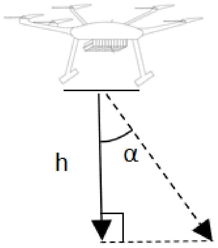
[0094] In one embodiment, the wind direction information is acquired by the wind speed wind direction sensor 514 of the plant protection drone. After the AD conversion, the electrical signal conversion acquires the drug drifting information, and shared to the control station; the laser radar on the plant protection drone measured the plant protection The third height difference H between the top of the target fruit crown layer is shared to the control station; the control station acquires the liquid offset angle α according to the drug drifting information and the third height difference H, Figure three Indicated.
[0095] According to the target information, the fourth height difference between the top of the target fruit crown and the ground apparent drone spray arm can be obtained. 0; Depending on the liquid displacement angle α, the vehicle tree distance and the fourth height difference H 0 , The elevation angle of the ground apparent drone and the liquid offset region is θ 1 The difference is the third angle θ 3; According to the current wind speed wind direction information, adjust the third angle θ again to the brunette arm of the ground application drone 3 Where the third angle θ 3 Adjustment Figure four Indicated.
[0096] This embodiment passes the drift information collected by the sensor to the control station, and the liquid solution is obtained in the range of fruit tree degradation, and the corresponding adjustment is performed by the application of the ground application drone spray arm. The plant protection drift drift part realizes the full coverage of the application, achieving average of the fruit tree prevention and control, and finally reaches the target of the orchard tree target.
[0097] Based on the content of any of the above embodiments, as an alternative embodiment, the first angle calculation formula is:
[0098] θ 1 = Arctan (H 1 / L);
[0099] Among them, θ 1 First angle, h 1 For the first threshold height, L is the distance of the car tree.
[0100] Based on the content of any of the above embodiments, the calculation formula of the second angle is:
[0101] θ 2 = Arctan (H 2 / L);
[0102] Among them, θ 2 Second angle, H 2 For the second threshold height, L is the distance of the car tree.
[0103] Based on the content of any of the above embodiments, as an alternative embodiment, image 3 It is a schematic diagram of the determination of the liquid offset angle α provided by the present invention, such as image 3 As shown, the calculation formula of the third angle is:
[0104]
[0105]
[0106] Where alpha is the liquid offset angle, H is the third height difference, θ 3 For the third angle, h 0 For the fruit tree special information, the fourth height difference between the top of the fruit crown and the ground application drone spray arm, V is the wind speed in the current wind speed wind direction, and L is the distance, H 1 For the first threshold height.
[0107] Among them, the side wind compensation ground application drone spray arm angle θ 3 Method Figure 4 As shown: By measuring the distance of the plant protection drone generated by measuring the distance from the air-ranging from the air-speed generation 偏移 :
[0108]
[0109] Where H 相对偏移 The calculation formula is:
[0110] hide 相对偏移 = H + H 0 -H 偏移;
[0111] Ground application drone nombrane arm angle θ 3 The first angle θ 1 And the height H of the plant protection drone 偏移 Offset, offset angle α, water discharge gas flow sensor 524 at high height h 0 The relationship between the distance L of the car tree is as follows:
[0112]
[0113] The relationship between the ground apparent drone armor angle θ and the offset angle α is as follows:
[0114]
[0115] Where alpha is the liquid offset angle, H is the third height difference, θ 3 For the third angle, h 0 For the fruit tree special information, the fourth height difference between the top of the fruit crown and the ground application drone spray arm, V is the wind speed in the current wind speed wind direction, and L is the distance, H 1 For the first threshold height.
[0116] Figure 5 It is a schematic structural diagram of the plant-protection drone and the ground apparent drone device provided by the present invention, as an alternative embodiment, such as Figure 5 As shown, the plant protection drone 51 contains the following systems:
[0117] Image acquisition system 511 for scanning shooting to the job orchard; the system includes 3D camera and laser radar; where 3D cameras are used to get three-dimensional dot cloud images of fruit trees, laser radar is used to obtain remote sensing images of the orchard of the orchard;
[0118] Plant Protection UAV GPS Positioning System 512, is used to position the work orchard and the target fruit tree, so that the plant protection drone will work according to the collaborative operation path;
[0119] Plant Protection Drone Common Work Spray Control System 513 for aerial operations for the work orchard.
[0120] Wind speed wind direction sensor 514 for acquiring wind speed wind direction information;
[0121] Ground application drone 52 contains the following systems:
[0122] Control station 521, information sharing and processing information on information ground application drones and plant protection drones, and controls plant protection drones and ground application drones;
[0123] Ground application drone synergistic work spray control system 522 for treating the work orchard on the ground job, including a wind-acting spray arm;
[0124] Ground apparel drone GPS positioning system 523, used to make the ground application drone in accordance with the synergistic operation path.
[0125] The underwash the gas flow sensor 524 is used to measure the strength of the ground-absorbing airflow intensity of the ground application drone in the position;
[0126]The ranging system 525 is used to measure the distance between the spray arm and the target tree, including laser radar.
[0127] Figure 6 It is a flow schematic diagram of the method of airborne synergistic apparatus provided by the present invention, as an alternative embodiment, such as Figure 6 As shown, the plant protection drone is in the process of collecting the information, using the plant protection drone GPS positioning system 512 to obtain the orchard geographic location, and take the job orchard to scan the work orchard through the laser radar and 3D camera of the image acquisition system 511. Remote sensing image and three-dimensional point cloud image; remote sensing image includes geographical feature information such as orchard area, terrain, fruit tree density, or garden boundary information, three-dimensional point cloud image includes a shape, size profile, volume, and fruit tree top and ground apparatus Height difference between the human car spray arm 0 Equisical tree feature information.
[0128] The control station 521 shares a plant protection drone remote image and a three-dimensional point cloud image, and uses the image stitching method based on the SURF algorithm, extracts the characteristic point of each map, and performs image registration according to the matching of the feature point, copy the image to the corresponding The specific location of the image, the overlapping boundary is degraded, and the fusion of the remote sensing image and the three-dimensional point cloud image is realized, and the target information is extracted.
[0129] For the obtained target information, the control station 521 is written according to the principles of the three-dimensional modeling and the 3D reconstruction of the orchard of the orchard, and the algorithm reconstructed the crown structure map, and the algorithm is reconstructed. The three-dimensional model, including geographic feature information such as orchard area, terrain, fruit tree density, and orchard information, as well as the shape of the fruit tree, the size of the size and the top of the crown and the ground application drone spray arm 0 Equisical tree feature information, fully covered with orchard target information.
[0130] According to the actual situation, the synchronous operation path or asynchronous job path of the plant protection drone and the ground application drone operation is planned in the ground application drone control station microprocessor, where the view method It is a path planning algorithm based on environment modeling.
[0131] In the case of synchronous homework, the control station 521 shares the synchronous job path to the plant protection drone and ground application drone, and controls the plant protection drone and the ground application drone according to the synchronous operation path to the same goal. Spray operation, plant protection drone to operate the upper part of the target fruit tree crown, by adjusting the ground application of the coordinated work spray control system 522 to the lower part of the target fruit tree crown (the plant protection drone ) Replenishing the spray, realizing the full coverage of the liquid. Depending on the weather conditions, it is necessary to need a side wind compensation. The gain of the external environment causes the drug drift, and the wind speed wind direction sensor 514 transmits the wind speed wind direction information to the control station 521, and issues an instruction after the control station 521 is processed, and the synergistic work spray The ground application of the control system 522 realizes the side wind compensation, and the prevention and treatment of fruit spray is completed.
[0132] In the case of asynchronous operations, the control station 521 shares the asynchronous job path to the plant protection drone and ground application drone, the plant protection drone first, according to the need to treat the orchards of the work orchard, the upper part of the crown layer of the work orchard, in accordance with the needs of the asynchronous operation The ground application drone receives information to make a next response, according to the average value of the plant protection drone in the orchard, the average value of the synergistic spray control system 522, the surface application drone sprinkler arm angle, and According to the asynchronous job path, the fruit tree crown under the lower part of the fruit crown is supplemented, and the liquid solution is fully covered with fruit trees, and the fruit spray prevention and treatment task is completed.
[0133] The present embodiment can be flexibly planning a collaborative job path according to the actual situation, and the scope of application is wider according to the actual situation.
[0134] Figure 7 It is a schematic structural diagram of the airborne synergistic application system provided by the present invention, such as Figure 7 As shown, including but not limited to the following unit:
[0135] The target information acquisition unit 701 is used to obtain target information of the orchard to be operated;
[0136] The path planning unit 702 is used to determine the synergistic operation path of the plant protection drone and the ground application without the target information;
[0137] The control unit 703 is used to control the plant protection drone and the ground application drone in accordance with the synergistic operation path.
[0138] The target information acquisition unit 701 acquires the target information of the orchard to be operated, the target information includes geographic feature information and fruit tree feature information; according to the target information, the path planning unit 702 determines the synergistic operation path of the plant protection drone and the ground application drone; control Unit 703 controls plant protection drones and ground application drones to synergist of synergistic operations.
[0139] Specifically, in practical applications, first, use the positioning system on the plant protection drone to locate the orchard to scan shooting through the image acquisition system 511, and obtain the remote sensing image of the orchard and the three-dimensional dot cloud image. Among them, the geographic feature information of the orchard of the orchard from the remote sensing image can be extracted from the three-dimensional point cloud image, and the fruit tree feature information of the orchard to be operated can be extracted.
[0140] Among them, geographic feature information may include information such as the area, terrain, fruit tree density and orchard information of the orchard information of the orchard information of the orchard. The fruit tree special information can include: the shape of the fruit tree, the size of the size, the volume, and the top of the crown layer and the ground apparer unmanned vehicle spray arm. 0 And other information.
[0141] Specifically, the plant protection drone is small, and the load capacity is strong. When it is sprayed in the air, the working efficiency is high, and the down-washing gas generated by the rotor is contribute to the penetration of the fog flow of the liquid. Have a good prevention effect.
[0142] Alternatively, the positioning system can be a GPS positioning system, a Beidou system, a Glonass system, or a gallerist satellite navigation system, and in the subsequent embodiment of the present invention, it will be described as an example in which the GPS positioning system is positioned as an example, which is not considered to this The invention is defined.
[0143] Alternatively, the image acquisition device can be an infrared scanner, a line array camera, a depth camera, or a high-spectral camera.
[0144] Further, the control station is fused to fuse the remote sensing image, acquire the fusion information image, and the target information acquisition unit 701 extracts target information including geographic feature information and fruit tree feature information.
[0145] Alternatively, after the image stitching method based on the SURF algorithm is extracted, the image registration is performed according to the matching of the feature point, and the image is copied to the specific position of the corresponding image, and the overlapping boundary is degraded. Implement the fusion of remote sensing images and 3D point cloud images.
[0146] Further, according to the target information, first treat the work orchard for three-dimensional modeling, then the path planning unit 702 performs path search based on the path search algorithm, determines a walking path to obtain an optimal value of the predetermined performance function, and determine the plant protection drone and Synergistic work path for ground application drones.
[0147] Among them, three-dimensional modeling is carried out to establish an environment model used to facilitate the path planning of the computer, and the actual physical space is abstracted into an algorithm can handle abstract space, and realize the mutual mapping.
[0148] The search path is not necessarily a feasible path that can walk in a ground application drone, which needs further processing and smooth to make it a practical path.
[0149] Alternatively, the path search algorithm can be a Dijkstra algorithm, a SPFA algorithm, a Bellman-Ford algorithm, a Floyd-Warshall algorithm, or a Johnson algorithm.
[0150] Alternatively, the planning path method can be a geometric method, a unit division method, an artificial field method, a grid method, a digital analysis method.
[0151] Among them, the best value obtained for performance functions, its optimal reflection is based on comprehensive operation of the work orchard to ensure that the plant protection drone and the ground application drone have the shortestation, no repetitive operation or omission operation.
[0152] Among them, the underwash gas flow sensor 524 of the ground apparer drone is mounted to the height of the same horizontal plane with the ground apparent drone spray arm.
[0153] Further, the control unit 703 controls the plant protection drone and the ground application drone according to the synergistic operation path, and the plant protection drone treats the upper part of the fruit garden of the work orchard for applying medicine, ground application drone According to the current water purification stream intensity, it is determined that the plant protection drone is not approved, and the angle of the ground application drone ball injection arm should be adjusted, and the lower part of the fruit crown layer is supplemented, and the liquid liquid is fully covered with fruit trees. .
[0154] The air-ground synergistic application system provided by the present invention is based on the characteristic information of the orchard and the fruit tree. On this basis, the control of the plant protection drone and the ground application drone shall be operated according to the planned synergistic operation path. The way of spraying in the air, using ground application drones to supplement the plant protection drone operation blind spot, realize the comprehensive cover of the fruit trees, maximize the drug utilization, reduce the negative effects of pesticide spraying Reduce environmental pollution, optimize spray control methods and effects, so that the fruit tree disease is effectively prevented, and it can effectively guarantee the protection of fruit and increase production.
[0155] It should be noted that the empty coordinated apparatus system provided by the embodiment of the present invention may be implemented in accordance with the empty cooperative application of any of the above embodiments, and will not be described in the present embodiment.
[0156] Figure 8 It is a structural diagram of the electronic device provided by the present invention, such as Figure 8 As shown, the electronic device can include a processor 801, a communication interface 802, a memory 803, and a communication bus 804, wherein the processor 801, a communication interface 802, a memory 803 via a communication bus 804. Complete communication between each other. Processor 801 can call logic instructions in memory 803 to perform empty coordinating application methods, including:
[0157] Get the target information of the orchard to be horn, the target information includes geographic feature information and fruit tree feature information; according to target information, determine the synergistic operation path of the ground application drone and the plant protection drone; control ground application drone and plant protection The human machine is working in collaborative operations.
[0158] Further, the logic instructions in the above-described memory 803 can be implemented in a computer-readable storage medium when the software function unit is implemented and used as a separate product sales or in use. Based on this understanding, the technical solution of the present invention essentially ors a portion of the prior art or a portion of the technical solution can be embodied in the form of a software product. The computer software product is stored in a storage medium, including Several instructions are used to enable a computer device (which can be a personal computer, server, or network device, etc.) to perform all or some steps of the various embodiments of the present invention. The aforementioned storage medium includes: U disk, mobile hard disk, read-only memory (ROM, RAD-ONLY MEMORY), random access memory (RAM, RANDOM Access Memory), disk or disc or optical discs can store program code .
[0159]On the other hand, the present invention also provides a computer program product that includes a computer program stored on a non-transitory computer readable storage medium. The computer program includes program instructions, and when the program command is executed by the computer, the computer can perform The method provided by each of the above methods includes: obtaining target information of the orchard to be operated, the target information includes geographic feature information and fruit tree feature information; according to target information, determining the ground application drone and plant protection The collaborative operation path of the machine; controlling the ground application drone and the plant protection drone according to the collaborative operation path.
[0160] Yet another aspect, the present invention also provides a non-transitory computer readable storage medium, which stores a computer program that is implemented when executed by the processor to perform the air-like coordination apparatus for each of the above embodiments. Methods include:
[0161] Get the target information of the orchard to be horn, the target information includes geographic feature information and fruit tree feature information; according to target information, determine the synergistic operation path of the ground application drone and the plant protection drone; control ground application drone and plant protection The human machine is working in collaborative operations.
[0162] The device embodiment described above is merely schematic, wherein as the separation member explains may or may not be physically separated, and the components displayed as the unit may be or may not be a physical unit, that is, it can be located in one place. Or can also be distributed to multiple network units. The object of the present embodiment can be implemented in accordance with the actual needs to select the part or all of the modules. One of ordinary skill in the art can understand and implement without the creative labor.
[0163] Through the description of the above embodiments, those skilled in the art will clearly understand that the embodiments can be implemented by means of software plus necessary, of course, can of course pass through hardware. Based on this understanding, the above technical solution essentially or contributes to the prior art can be embodied in the form of software products, which can be stored in a computer readable storage medium, such as ROM / RAM, magnetic Disc, optical disc, etc., including several instructions to enable a computer device (which can be a personal computer, server, or network device, etc.) to perform certain portions of various embodiments or embodiments.
[0164] It will be noted that the above embodiments are intended to illustrate the technical solutions of the present invention, not to limit the present invention, and will be apparent to those skilled in the art, which will be understood by those skilled in the art. The technical scheme described in the foregoing embodiments is modified, or the equivalent replacement thereof is performed in which these modifications or replacements do not allow the nature of the respective technical solutions to the spirit and scope of the technical solutions of the present invention.
Login to view more PUM


Description & Claims & Application Information
We can also present the details of the Description, Claims and Application information to help users get a comprehensive understanding of the technical details of the patent, such as background art, summary of invention, brief description of drawings, description of embodiments, and other original content. On the other hand, users can also determine the specific scope of protection of the technology through the list of claims; as well as understand the changes in the life cycle of the technology with the presentation of the patent timeline. Login to view more.
Login to view more Similar technology patents
Immersed ultrafiltration membrane chemical cleaning liquid medicine recycling method
PendingCN114699923AImprove utilization efficiencyImprove drug utilizationSemi-permeable membranesWater/sewage treatment by neutralisationUltrafiltrationWater tanks
Owner:江苏道科环境科技有限公司
Medicine for treating meat rabbit colibacillosis and preparation method thereof
InactiveCN107296920AEnhance immune functionImprove drug utilizationAntibacterial agentsPowder deliveryCinnamomum camphoraRadix Astragali seu Hedysari
Owner:普定县陇泉湾养殖有限公司
Exogenous peptide mediated membrane fusion drug delivery system and evaluation method thereof
PendingCN114272386AImprove drug utilizationReduce damageMacromolecular non-active ingredientsLiposomal deliveryPeptideDrug efficiency
Owner:SHENZHEN PKU HKUST MEDICAL CENT +1
Method for improving tobacco bacterial wilt resistance
InactiveCN106818326ASustained Release and Drug UtilizationImprove drug utilizationGrowth substratesCulture mediaNicotiana tabacumBiotechnology
Owner:新昌县钧国生物技术有限公司
Spleen-tonifying navel patch medicament
InactiveCN111632123AImprove absorption rateImprove drug utilizationDigestive systemInorganic non-active ingredientsPenetration enhancerBiomedical engineering
Owner:陈海燕
Classification and recommendation of technical efficacy words
- Improve drug utilization
- Reduce negative impact
Auxiliary treatment device for child allergic asthma
ActiveCN107080887AEasy to operateImprove drug utilizationRespiratorsDispersed particle filtrationIonizationPre filtering
Owner:尹文艳
Method for preparing core-shell type polysaccharide gum location targeting carrier material
InactiveCN105148281AReduce drug contentImprove drug utilizationOrganic active ingredientsEnergy modified materialsChemistryDrugs toxicity
Owner:ZHONGBEI UNIV
Medicinal paste for treating hyperosteogeny and bone wound and its preparing method
InactiveCN1562159AImprove transdermal absorption rateImprove drug utilizationAntipyreticAerosol deliveryMyrrhHyperostosis
Owner:江西昌正科技产业有限公司
Method for treatment of oily sludge
PendingCN110054393AImprove oil washing efficiencyImprove drug utilizationSludge treatment by de-watering/drying/thickeningLiquid hydrocarbon mixture productionDeep levelDepth level
Owner:TIANJIN UNIV
Deep dehydration pretreatment process for landfill sludge
ActiveCN109485230AImprove drug utilizationAvoid excessive dilutionSludge treatment by de-watering/drying/thickeningWater contentPre treatment
Owner:SHANGHAI UNIVERSITY OF ELECTRIC POWER
Composition and method for treating fat tissues and inflammatory processes
InactiveUS20140017341A1Reduced activityReduce negative impactBiocideCosmetic preparationsCell agingHsp Inhibitor
Owner:GOURLAOUEN BRIGITTE
On-vehicle head-up terminal and method for controlling display brightness of the same
InactiveCN105301774AReduce negative impactDistractionOptical viewingOptical elementsHead-up displayEyeball movements
Owner:QINGDAO GOERTEK
Crowd number counting method and system based on scale adaptive network
ActiveCN110135325ADensely distributedReduce negative impactImage enhancementImage analysisSelf adaptiveCrowds
Owner:SHANDONG UNIV