A land cover mapping method

A cover and land technology, applied in image analysis, image enhancement, image data processing, etc., can solve the problems of low accuracy of land cover data, insufficient large-scale data fusion algorithm, poor consistency, etc.

Active Publication Date: 2021-11-02
INST OF GEOGRAPHICAL SCI & NATURAL RESOURCE RES CAS
View PDF8 Cites 0 Cited by
  • Summary
  • Abstract
  • Description
  • Claims
  • Application Information

AI Technical Summary

Problems solved by technology

[0005] The present invention provides a land cover mapping method to solve one or more of the current technical problems of low precision and poor consistency of land cover data, and insufficient application of data fusion algorithms on a large scale

Method used


Image

  • A land cover mapping method

Examples


Embodiment

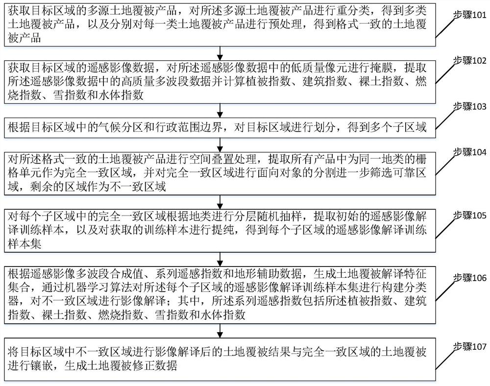
[0048] Please refer to figure 1 , a flow chart of the steps of a land cover mapping method provided in an embodiment of the present invention, including steps 101 to 107, each step is specifically as follows:

[0049] Step 101, obtain multi-source land cover products in the target area, reclassify the multi-source land cover products to obtain multiple types of land cover products, and perform preprocessing on each type of land cover products respectively to obtain Consistently formatted land cover products.

[0050] In this embodiment, before the reclassification of the multi-source land cover products, it includes: performing framing combined mosaic and mask extraction on each multi-source land cover product.

[0051] In this embodiment, the step of preprocessing each type of land cover product includes: performing unified processing on the spatial range and reference coordinate system of the land cover product; The format of the product is unified into a raster format; th...


PUM


Abstract

The invention discloses a land cover mapping method, which extracts effective information of existing land cover products by establishing a multi-source data spatial consistency identification and sample statistical screening method, and applies the method based on a remote sensing cloud computing platform and massive remote sensing images The machine learning algorithm corrects the inconsistent information among various land cover products, which solves the problems of poor consistency and low precision of the current multi-source land cover data; It can effectively solve the difficulty of insufficient training samples on cloud computing platforms such as Google Earth Engine; this technical solution does not require reference sample points and prior knowledge for field land cover interpretation, and can quickly and accurately generate high-resolution images of large-scale areas. Land cover data fusion products can effectively realize high-precision and high-efficiency land cover mapping and are portable.

Description

technical field [0001] The invention relates to the field of land cover information, in particular to a method for mapping land cover. Background technique [0002] Land use and land cover are the link between human socioeconomic activities and natural ecological processes, and directly represent the impact of human activities on the surface ecosystem. Accurate land cover data are important basic data for research on global change, land surface process simulation, ecological civilization construction, and regional sustainable development, and play an important role in the sustainable use of land resources and government decision-making. Remote sensing data has become the main means of drawing land cover data on a large scale. Since the accuracy of existing products is not high and there are obvious differences when applied to regional or global scales, the use of data fusion methods can effectively overcome the incompatibility of current land cover data sets. , comparabilit...

Claims


Application Information

Patent Timeline
Patent Type & Authority Patents(China)
IPC IPC(8): G06T7/11G06T7/187G06T5/00G06T5/40
CPCG06T5/002G06T5/40G06T2207/10032G06T2207/20081G06T2207/30184G06T7/11G06T7/187
Inventor 许尔琪李科为
Owner INST OF GEOGRAPHICAL SCI & NATURAL RESOURCE RES CAS
Why Eureka
Try Eureka