
Deep learning remote sensing image semantic segmentation method and system based on U-NET

A remote sensing image and semantic segmentation technology, which is applied in neural learning methods, instruments, biological neural network models, etc., can solve the problem of large workload, long time-consuming development of high-resolution remote sensing satellites, and difficulties in meeting the requirements of segmentation accuracy and segmentation target categories And other issues

Pending Publication Date: 2021-09-14
广州观必达数据技术有限责任公司
View PDF0 Cites 3 Cited by
  • Summary
  • Abstract
  • Description
  • Claims
  • Application Information

AI Technical Summary

Problems solved by technology

With the advancement of technology, image segmentation algorithms such as edge-based multispectral methods, phase-consistent segmentation methods, and marker-based watershed algorithms are currently used to segment remote sensing images. However, remote sensing images are vulnerable to atmospheric, temperature and other factors. When there are significant differences between geological conditions, ecological environment and monitoring targets, it is difficult for the above image segmentation algorithm to obtain robust results in different remote sensing scenarios; in addition, when the target to be segmented changes , the above image segmentation algorithm needs to manually select new segmentation target features, which in turn generates a lot of workload;
[0003] In addition, high-resolution remote sensing satellites have limitations such as long development time, high operating costs, and complex operating procedures, so it is difficult to obtain high-resolution remote sensing images captured by them, and it is often necessary to perform super-resolution based on a given low-resolution remote sensing image. High-rate reconstruction, and restore its processing to the corresponding high-resolution image, so as to improve the resolution of the observed image without changing the detection system
[0004] It can be seen that the existing common image segmentation algorithms are difficult to meet the current requirements for segmentation accuracy and segmentation target categories in the multi-target accurate segmentation, and cannot be directly applied to the field of super-resolution reconstruction

Method used


Image

  • Deep learning remote sensing image semantic segmentation method and system based on U-NET
  • Deep learning remote sensing image semantic segmentation method and system based on U-NET
  • Deep learning remote sensing image semantic segmentation method and system based on U-NET

Examples


Embodiment 1

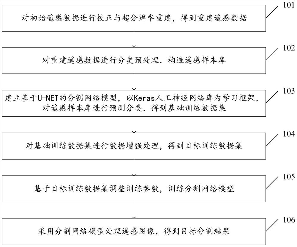
[0079] see figure 1 , figure 1 It is a schematic flowchart of a U-NET-based deep learning remote sensing image semantic segmentation method disclosed in an embodiment of the present invention. Such as figure 1 As shown, the U-NET-based deep learning remote sensing image semantic segmentation method may include the following steps.

[0080] 101. Perform correction and super-resolution reconstruction on the initial remote sensing data to obtain reconstructed remote sensing data.

[0081] In this embodiment, the low-resolution initial remote sensing data is corrected and reconstructed to provide standardized high-resolution remote sensing data for subsequent segmentation.

[0082] As an optional implementation, atmospheric correction and radiation correction are performed on the initial remote sensing data to obtain the corrected image; denoising and upsampling are performed on the corrected image to obtain the characteristic image; the nonlinear features contained in the char...

Embodiment 2

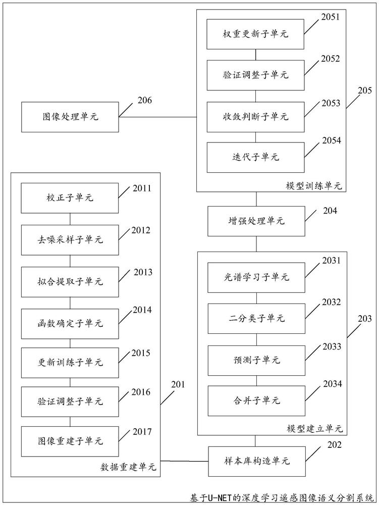
[0099] see figure 2 , figure 2 It is a schematic structural diagram of a U-NET-based deep learning remote sensing image semantic segmentation system disclosed in an embodiment of the present invention. Such as figure 2 As shown, the U-NET-based deep learning remote sensing image semantic segmentation system may include the following contents.

[0100] A data reconstruction unit 201, configured to perform correction and super-resolution reconstruction on the initial remote sensing data to obtain reconstructed remote sensing data;

[0101] The sample library construction unit 202 is used to classify and preprocess the reconstructed remote sensing data and construct a remote sensing sample library;

[0102] The model building unit 203 is used to set up a segmented network model based on U-NET, and use the Keras artificial neural network library as a learning framework to predict and classify the remote sensing sample library to obtain a basic training data set;

[0103] An...

Embodiment 3

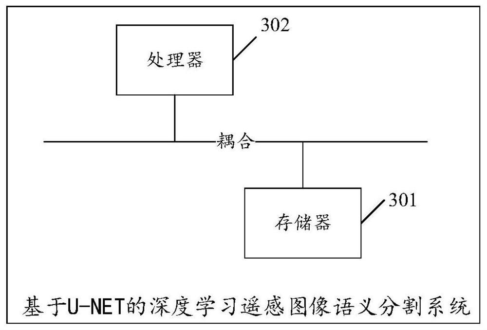
[0130] see image 3 , image 3 It is a schematic structural diagram of another U-NET-based deep learning remote sensing image semantic segmentation system disclosed in the embodiment of the present invention. Such as image 3 As shown, the U-NET-based deep learning remote sensing image semantic segmentation system can include:

[0131] A memory 301 storing executable program codes;

[0132] a processor 302 coupled to the memory 301;

[0133] Wherein, the processor 302 invokes the executable program code stored in the memory 301 to execute figure 1 A deep learning remote sensing image semantic segmentation method based on U-NET.

[0134] The embodiment of the present invention discloses a computer-readable storage medium, which stores a computer program, wherein the computer program enables the computer to execute figure 1 A deep learning remote sensing image semantic segmentation method based on U-NET.

[0135] The embodiment of the present invention also discloses a comp...


PUM


Abstract

The invention discloses a deep learning remote sensing image semantic segmentation method and system based on U-NET, and the method comprises the steps: carrying out the correction and reconstruction of initial remote sensing data, carrying out the classification preprocessing, constructing a remote sensing sample library, carrying out the prediction classification based on a segmentation network model, obtaining a basic training data set, and carrying out the enhancement processing, thereby obtaining a target training data set, and processing the remote sensing image by using the trained segmentation network model to obtain a target segmentation result. According to the method, atmospheric correction and radiation correction are adopted to eliminate radiation quantity errors and interference data, and then super-resolution reconstruction is performed on the remote sensing image, so that interference of external factors is effectively avoided, and the resolution requirement on the remote sensing image is reduced; and the segmentation network model can adaptively learn the characteristics of different targets and realize multi-target segmentation in the same remote sensing image, so that when the segmentation target is changed, only the corresponding data set needs to be adopted to retrain the segmentation network model, the manual reconstruction of the characteristics and the algorithm is not needed, and the workload is greatly reduced.

Description

technical field [0001] The invention relates to the technical field of remote sensing image segmentation, in particular to a U-NET-based deep learning remote sensing image semantic segmentation method and system. Background technique [0002] Remote sensing images usually refer to digital images captured by aviation or aerospace platforms. Traditionally, the analysis of remote sensing data relies on a large number of manual operations, supplemented by some relatively simple statistical image processing methods. With the advancement of technology, image segmentation algorithms such as edge-based multispectral methods, phase-consistent segmentation methods, and marker-based watershed algorithms are currently used to segment remote sensing images. However, remote sensing images are vulnerable to atmospheric, temperature and other factors. When there are significant differences between geological conditions, ecological environment and monitoring targets, it is difficult for the ...

Claims


Application Information

Patent Timeline
IPC IPC(8): G06K9/34G06N3/04G06N3/08
CPCG06N3/084G06N3/045
Inventor 潘颖何卓彦陈洋臣
Owner 广州观必达数据技术有限责任公司
Learn More