Water quality monitoring network positioning method based on RSSI distance measurement

A technology for network positioning and water quality monitoring, applied in location information-based services, network topology, wireless communication, etc., can solve the problem of not being able to effectively reduce ranging errors, not being able to meet the positioning needs of the positioning cost water quality online monitoring system, and being unable to apply water quality monitoring System and other issues

Pending Publication Date: 2021-09-28
HUAIYIN INSTITUTE OF TECHNOLOGY
View PDF0 Cites 2 Cited by
  • Summary
  • Abstract
  • Description
  • Claims
  • Application Information

AI Technical Summary

Problems solved by technology

However, RF signal propagation modeling is affected by environmental factors, and appropriate measures need to be taken to reduce ranging errors
However, in the existing positioning methods, the ranging error cannot be effectively reduced, so that the positioning method

Method used


Image

  • Water quality monitoring network positioning method based on RSSI distance measurement
  • Water quality monitoring network positioning method based on RSSI distance measurement
  • Water quality monitoring network positioning method based on RSSI distance measurement

Examples


Embodiment Construction

[0050] The present invention will be further described below in conjunction with embodiment.

[0051] The invention provides a water quality monitoring network positioning method based on RSSI ranging, comprising the following steps:

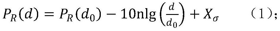
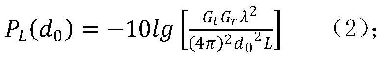
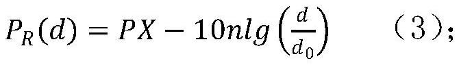
[0052] Step 1: In the lake and river environment where the water quality monitoring system is placed, various species and sizes of biological fish and other facilities are densely distributed and unevenly distributed, so factors such as multipath, diffraction, and obstacle occlusion influence, making the RF signal propagation model complicated. In order to adapt to the lake and river environment of the water quality monitoring system, the simplified lognormal distribution model is used for distance measurement, and the RF communication modeling is established according to formula (1);

[0053]

[0054] In the formula, n is the path loss index, the value is between 2 and 4, and the more the number of obstacles and occlusions, the greater the ...


PUM


Abstract

The invention relates to a water quality monitoring network positioning method based on RSSI distance measurement. The method comprises the following steps: establishing RF communication modeling; obtaining path loss PL (d0) after the wireless signal passes through the reference distance d0; periodically measuring received signal strength RSSI between a node to be positioned and a neighbor reference node thereof, and then calculating a path loss index n in a current monitoring area by using an RF wireless signal propagation model; according to the known reference node coordinates, comparing the measured distance between the reference nodes with the actual distance to obtain the relative ranging error of the RSSI; establishing a distance equation of the monitoring nodes, carrying out Taylor series expansion, adopting a weighted least squares (WLS) algorithm for processing, and updating parameter vectors. The method can effectively reduce distance measurement errors, can enable the positioning method based on RSSI distance measurement to be suitable for water quality monitoring systems in various different environments, and can meet the positioning requirements of water quality online monitoring systems with complex and severe network environments and limited positioning cost.

Description

technical field [0001] The invention belongs to the technical field of water quality monitoring, and in particular relates to a water quality monitoring network positioning method based on RSSI ranging. Background technique [0002] Wireless sensor networks (wireless sensor networks, WSN) can be self-organized and rapidly deployed, through its internal numerous sensor nodes to cooperatively perceive and collect environmental monitoring information, and take advantage of its distributed processing and multi-hop transmission to send the data processing results to the terminal device. The characteristics of strong fault tolerance and long working life of wireless sensor network make it have broad application prospects in the field of environmental water quality monitoring of lakes and rivers. The online water quality monitoring system integrating data collection, data transmission, predictive analysis and information display can enable the wireless sensor network to obtain dat...

Claims


Application Information

Patent Timeline
IPC IPC(8): H04W4/02H04W84/18
CPCH04W4/023H04W4/025H04W84/18
Inventor 常波张新荣
Owner HUAIYIN INSTITUTE OF TECHNOLOGY
Why Eureka
Try Eureka