GNSS-IR soil humidity inversion method based on generalized continuation approximation

A soil moisture, generalized technology, applied in soil material testing, satellite radio beacon positioning systems, measuring devices, etc., can solve problems such as the Runge phenomenon, errors, and difficulty in maintaining accurate and stable soil moisture, so as to reduce errors , Accurate and efficient extraction effect

Pending Publication Date: 2022-04-26
HANGZHOU DIANZI UNIV
View PDF0 Cites 2 Cited by
  • Summary
  • Abstract
  • Description
  • Claims
  • Application Information

AI Technical Summary

Problems solved by technology

However, there are still many problems that need to be improved. First, when calculating the satellite altitude angle, the precise ephemeris issued by the International GNSS Service Center (International GNSS Service, IGS) is limited to the time period of 00:00:00-23:45:00. And the sampling interval is as long as 15 minutes. If you want to get the satellite position at any time, you need to interpolate and extrapolate the precise ephemeris
In GNSS-IR related research, TEQC software (Translation, Editing and Quality Checking, TEQC) is usually used to process and directly obtain satellite position coordinates. Unsatisfactory effect
Secondly, due to the constant change of the satellite orientation during the observation process, the position of the corresponding mirror reflection point is also constantly changing, so when using the least squares sine fitting, there is a large error in calculating the signal-to-noise ratio oscillation frequency directly by using the antenna height
Finally, in the existing inversion model, when the satellite signal-to-noise ratio data is missing or the relative delay phase is abnormal, it is difficult to maintain accurate and stable soil moisture in GNSS-IR retrieval
In summary, in order to achieve comprehensive and accurate soil moisture monitoring, there are still many problems in GNSS-IR retrieval technology that need to be overcome urgently

Method used


Image

  • GNSS-IR soil humidity inversion method based on generalized continuation approximation
  • GNSS-IR soil humidity inversion method based on generalized continuation approximation
  • GNSS-IR soil humidity inversion method based on generalized continuation approximation

Examples


Embodiment Construction

[0046] The specific implementation cases of the present invention will be further described in conjunction with the accompanying drawings.

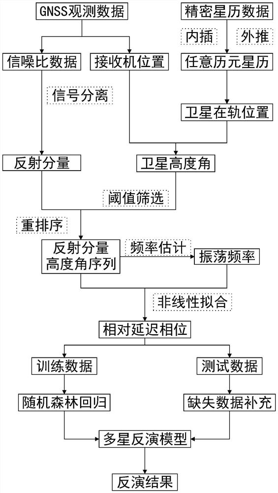
[0047] Such as image 3 As shown, the present invention utilizes the satellite signals collected by the measuring GNSS receiver to invert the near-surface soil moisture on the ground. This example is based on the premise of the solution of the present invention, and the satellite observation data of the Plate Boundary Observation Program (the Plate Boundary Observation, PBO) P041 station in 2011 is used as the test data for example description.

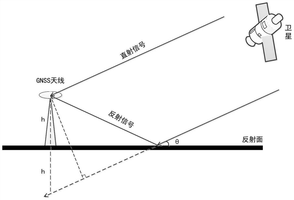
[0048] figure 1 It is the geometric relationship diagram of the satellite signal specular reflection in the GNSS-IR soil moisture retrieval process. It can be seen that the signal transmitted by the GNSS satellite is received by the GNSS antenna through the ground reflection. When the ground is relatively flat, θ is approximately the satellite elevation angle; h is the vertical height of the an...


PUM


Abstract

The invention discloses a GNSS-IR soil humidity inversion method based on generalized continuation approximation, and the method comprises the steps: carrying out the interpolation and extrapolation of a precise ephemeris through employing the signal-to-noise ratio observation data of a measurement type GNSS receiver through a generalized continuation approximation model, so as to obtain the elevation angle of each satellite in each epoch; the signal-to-noise ratio of the reflected signal obtained through trend separation by the local weighted regression method is reordered about the sine value of the satellite elevation angle, then the normalized Lomb-Scargle spectrum peak value is subjected to generalized continuation interpolation approximation to obtain the oscillation frequency, and a corresponding relative delay phase is obtained through nonlinear least square sine fitting; a soil humidity inversion model is established through a random forest, and finally, missing relative delay phase data is supplemented by adopting a generalized continuation interpolation method to serve as inversion model input to predict soil humidity. The method can adapt to the missing condition of observation data with different lengths and distribution, can maintain high inversion precision, and solves the problems in the prior art.

Description

technical field [0001] The present invention relates to the fields of global satellite navigation system interference reflection remote sensing technology, ecological environment monitoring and meteorological disaster prevention and control, specifically, a GNSS-IR (Global Navigation Satellite System-Interferometric Reflection) based on a generalized continuation and approximation model. System Interferometric Reflectometry) Soil Moisture Retrieval Method. Background technique [0002] Total soil moisture and surface soil water content are important environmental information in human production and life. Stable and accurate prediction of soil moisture changes is of great significance to meteorological geological disasters and water cycle research. Global Navigation Satellite System Interferometric Reflectometry (GNSS-IR) is a new type of non-cooperative passive remote sensing technology. Soil moisture can make good use of the advantages of navigation satellites all-weather,...

Claims


Application Information

Patent Timeline
Patent Type & Authority Applications(China)
IPC IPC(8): G01N33/24G01S19/39G06F17/18
CPCG01N33/246G01S19/39G06F17/18
Inventor 李方州尚俊娜施浒立
Owner HANGZHOU DIANZI UNIV
Why Eureka
Try Eureka