
Eureka
For R&D, Eureka makes reading and utilizing patents & technical documents easy.
Eureka AIR
Designed for self-driven R&D workflows. Generate viable solutions, solve complex R&D challenges, empower your innovation with AI.

Eureka Materials
Designed for material experts only. Revolutionize your material R&D, from search, analyze, to developing new materials.

TechResearch
Generate reliable direction feasibility study reports for your R&D in just a few steps.

TechSeek
Discover and master advanced knowledge NOW. Basics, ideas, possibilities, all at once.

TechMind
As an expert in R&D Theories, TechMind can generates customized viable solutions instantly.

TechRisk
Analyze your overall solution with one click, know your potential R&D risks in advance.

TechMonitor
Get weekly tech updates, stay abreast of the latest tech innovations and key insights.
Slope water and soil loss prediction method and system based on analog simulation technology
A technology for simulating and predicting methods, applied in the direction of design optimization/simulation, etc., can solve problems such as inability to use, achieve the effects of improving results, reducing estimation deviations, and shortening the experimental process
- Summary
- Abstract
- Description
- Claims
- Application Information
AI Technical Summary
Problems solved by technology
Method used
Image

Examples
Embodiment 1
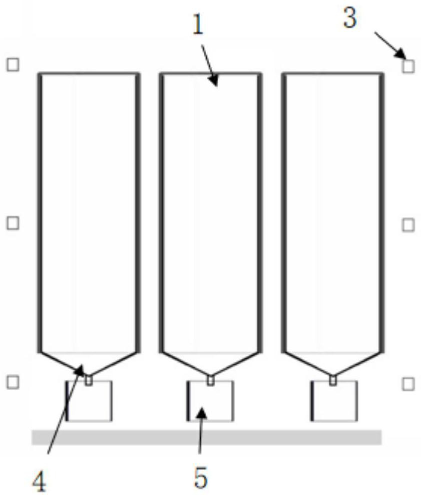
[0043] Build a simulation system: e.g. image 3 and Figure 4 As shown, the simulation system includes a first entity model, a second entity model, an electric mobile artificial rainfall simulation device, and a data acquisition device.
[0044] like figure 2 and image 3 As shown, the first solid model includes a plurality of runoff troughs with automatic slope change function, and the slope change range of the runoff troughs is 0-30 degrees. There are multiple compartments inside each runoff trough to facilitate comparisons between different surface types. The separation tank is filled with soil, and the soil is as compact as the site to be predicted. In this embodiment, the runoff trough adopts a steel structure with a length of 5m, a width of 2m and a height of 50-70cm; a steel plate with a length of 5m, a height of 80cm and a thickness of 3mm is vertically welded in the runoff trough every 50cm to form 4 partition slots; For anti-rust treatment, a layer of PVC plast...
Embodiment 2
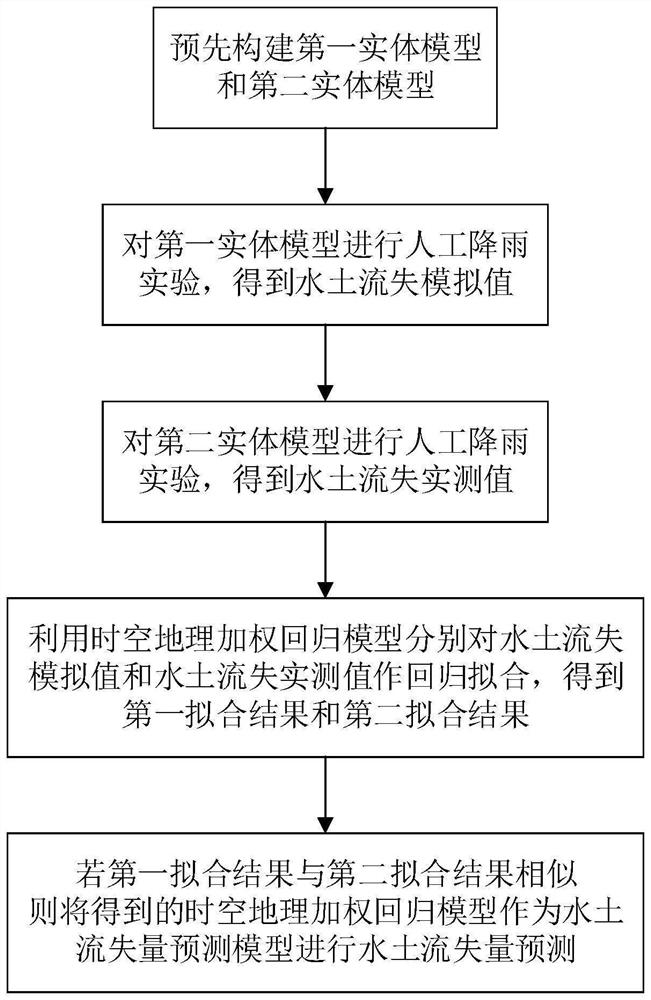
[0049] Predicting the amount of soil and water loss on the slope based on the simulation system built in the first embodiment includes the following steps:
[0050] S1. Perform multiple experiments on the first entity model to obtain n simulated values of soil and water loss:
[0051] Adjust the slope of the runoff trough to be consistent with the location to be predicted; control the nozzle to move above the runoff trough to simulate the average daily rainfall, rainfall intensity, and rainfall time at the location to be predicted to meet the simulated rainfall requirements.
[0052] After the rainfall, the runoff and sediment yields of each separation trough were obtained as the simulated values of soil and water loss.
[0053] S2. Perform multiple experiments on the second entity model to obtain n measured values of soil erosion:
[0054] Control the sprinkler to move above the field terrain model, and simulate the average daily rainfall, rainfall intensity, and rainfal...
Embodiment 3
[0075] Building the second entity model includes the following steps:
[0076] Use 3D laser scanning technology to obtain 3D point cloud data of the location to be predicted, and use a high-speed photocuring 3D printer to print a hollow model shell; prepare soil for terrain reconstruction, fill the model shell with soil and compact it , so that the soil and the internal concave-convex surface of the solid model shell fit together to achieve the effect of accurately restoring the details of the field terrain; after the soil is fully filled and compacted, the bottom bracket is installed and fixed, and the model of soil filling will be completed under normal topography. The shell is placed on the platform, and the model shell is removed to complete the preliminary construction of the second solid model.
[0077] Then, use the 3D laser scanning technology to obtain the 3D point cloud data of the second entity model, compare the 3D point cloud data of the second entity model and th...
PUM
 Abstract
Description
Claims
Application Information
 - R&D Engineer
- R&D Manager
- IP Professional
- Industry Leading Data Capabilities
- Powerful AI technology
- Patent DNA Extraction
Browse by: Latest US Patents, China's latest patents, Technical Efficacy Thesaurus, Application Domain, Technology Topic, Popular Technical Reports.
© 2024 PatSnap. All rights reserved.Legal|Privacy policy|Modern Slavery Act Transparency Statement|Sitemap|About US| Contact US: help@patsnap.com