Satellite direction finder and direction finding method

A technology for direction finders and satellites, which is applied in the field of azimuth measurement devices, can solve the problems of not meeting the basic requirements, not being able to solve the ambiguity, and not being able to obtain orientation solutions, so as to achieve the effect of improving direction finding accuracy and orientation accuracy

Inactive Publication Date: 2005-06-29
许其凤
View PDF0 Cites 15 Cited by
  • Summary
  • Abstract
  • Description
  • Claims
  • Application Information

AI Technical Summary

Problems solved by technology

The synchronous satellite navigation system only has two fixed-point geosynchronous satellites, which does not meet the basic requirements for observing more than 4 satellites; in addition, the apparent direction of the satellites is almost unchanged during the observation time, and the ambiguity cannot be solved (the rank deficiency of the listed equations )
That is to say, the directional solution cannot be obtained by using the existing theories and methods.

Method used


Image

  • Satellite direction finder and direction finding method
  • Satellite direction finder and direction finding method
  • Satellite direction finder and direction finding method

Examples


Embodiment Construction

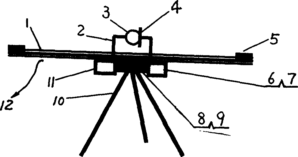
[0034] The satellite direction finder is a special equipment that uses carrier phase measurement to independently solve the azimuth. It focuses on solving the problem of using a single satellite to solve the azimuth and the initial epoch of the geosynchronous satellite to solve the ambiguity of the whole circle, so as to use two geosynchronous fixed-point satellites for direction finding. Such as figure 1 As shown, a rotating platform 12 that can be driven and rotated by a driving device 9 is installed on the support 10, satellite carrier phase measurement receiver antennas 5 are installed at both ends of the support arm 1 of the rotating platform 12, and an electronic recorder of the horizontal rotation angle is installed on the rotating platform 12. Device 8, vertical angle electronic recorder 4 and carrier phase measurement receiver 6, horizontal angle electronic recorder 8 and vertical angle electronic recorder 4 are used to record the rotation angle readings. Also be pro...


PUM


Abstract

This invention relates to satellite direction detector, which fixes rotation platform on the rack with satellite wave carrier phase measurement and receive antenna fixed on the both ends of the rotation platform. The rotation platform is fixed with telescope, level rotation angle electrical recorder, vertical angel electrical recorder and wave carrier phase measurement and receive machine and its step sample output is connected with the data process unit. The measurement method is the following: to drive rotation platform; in the same time to rotate platform and record angle as second impulse; to process data according to the math model able to weaken the system error; to computer the direction angle of the panel zero position; then to read out the direction angle from the dial panel for any point direction of the telescope.

Description

technical field [0001] The invention relates to an azimuth measuring device and a measuring method, in particular to an azimuth measuring device and a direction finding method using satellites. Background technique [0002] Existing satellite navigation systems, such as GPS in the United States, GLONASS in Russia and geosynchronous satellite navigation systems, have the function of positioning (giving the coordinates of the user's location), but there is no orientation (measurement of orientation) function in the system design. [0003] In addition to positioning, orientation is required in a large number of military and civilian applications. Usually the user needs to provide point coordinates and orientation at the same time. The use of navigation satellites to locate and determine the orientation can meet this requirement, and it has the characteristics of all-weather, fast and high precision. [0004] Since 1987, my country has started to use GPS satellites for azimuth...

Claims


Application Information

Patent Timeline
Patent Type & Authority Applications(China)
IPC IPC(8): G01C21/00
Inventor 许其凤
Owner 许其凤
Why Eureka
Try Eureka