
Deep ocean long range underwater navigation algorithm (UNA) for determining the geographic position of underwater vehicles

a long-range underwater navigation and geographic position technology, applied in the direction of measurement devices, design optimisation/simulation, instruments, etc., can solve the problems of inability to accurately determine the geographic position of underwater vehicles, inability to effectively deny underwater gps, and inability to maintain or restore accurate performance,

Active Publication Date: 2021-03-23
LEIDOS
View PDF26 Cites 4 Cited by
  • Summary
  • Abstract
  • Description
  • Claims
  • Application Information

AI Technical Summary

Benefits of technology

The patent text describes a new method for accurately positioning a vehicle using multiple sources of sound waves. The method involves measuring the time it takes for the sound waves to travel from the sources to the vehicle, and using this information to estimate the vehicle's position. The method takes into account the speed of sound in the ocean and the stability of the sound waves as they travel through the ocean. By measuring the time it takes for the sound waves to travel from the sources to the vehicle, and using this information to estimate the vehicle's position, the method provides a more accurate and reliable navigation system for underwater vehicles.

Problems solved by technology

Specifically, while the Global Positioning System (GPS) is the predominant means of obtaining positioning, navigation, and timing (PNT) information for both military and civilian systems and applications, the radio frequency basis for GPS also means that its signals cannot penetrate seawater, and thus undersea GPS is effectively denied.
However, while dead reckoning sensors may provide sole-source navigation for short duration missions, accumulation of inertial error eventually requires external measurements to maintain or restore accurate performance.
As a result, undersea vehicles must regularly surface to receive GPS signals and fix their position, and this presents a risk of detection.
In addition, the cost and power draw of state-of-the art undersea navigation sensors, such as a navigation grade IMU and Doppler velocity log (DVL), are significant ($100's K to $1M).
Both of these prior art efforts, however, do not include the simultaneous least squares estimate of the sound speed in their position / range calculations as discussed with respect to the present embodiments and neither effort has any ground truth of the actual glider position between the GPS positions at pre-dive and at post-dive.
Accordingly, actual range and position errors while the glider is submerged are not available.
However, Duda does not comment on the accuracy of the position, and there is neither data analyzed nor any algorithm that is discussed to achieve this positioning performance.

Method used


Image

  • Deep ocean long range underwater navigation algorithm (UNA) for determining the geographic position of underwater vehicles
  • Deep ocean long range underwater navigation algorithm (UNA) for determining the geographic position of underwater vehicles
  • Deep ocean long range underwater navigation algorithm (UNA) for determining the geographic position of underwater vehicles

Examples


Embodiment Construction

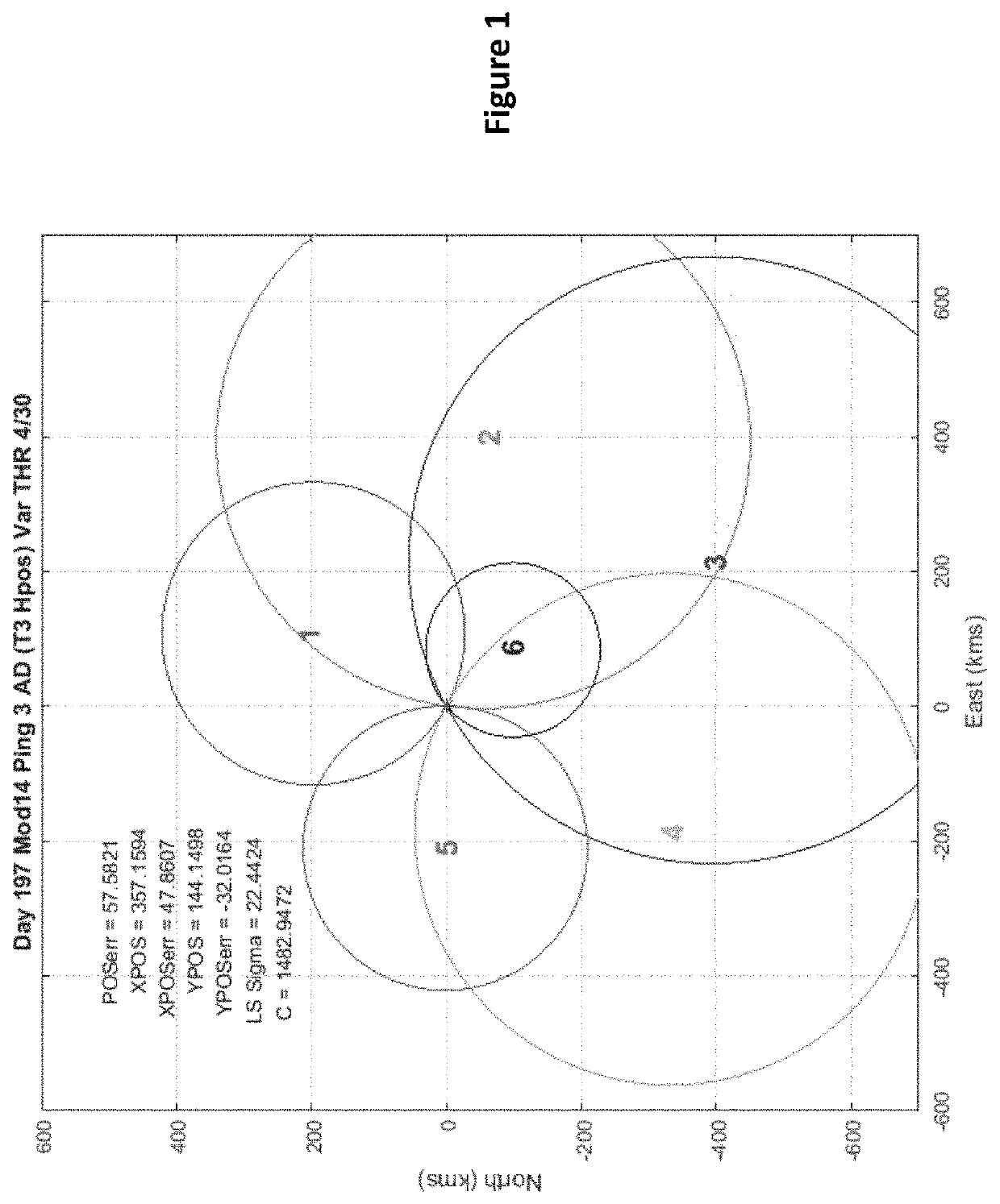
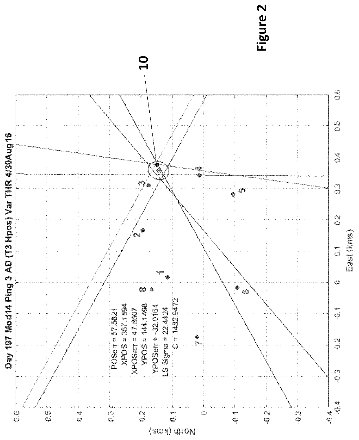
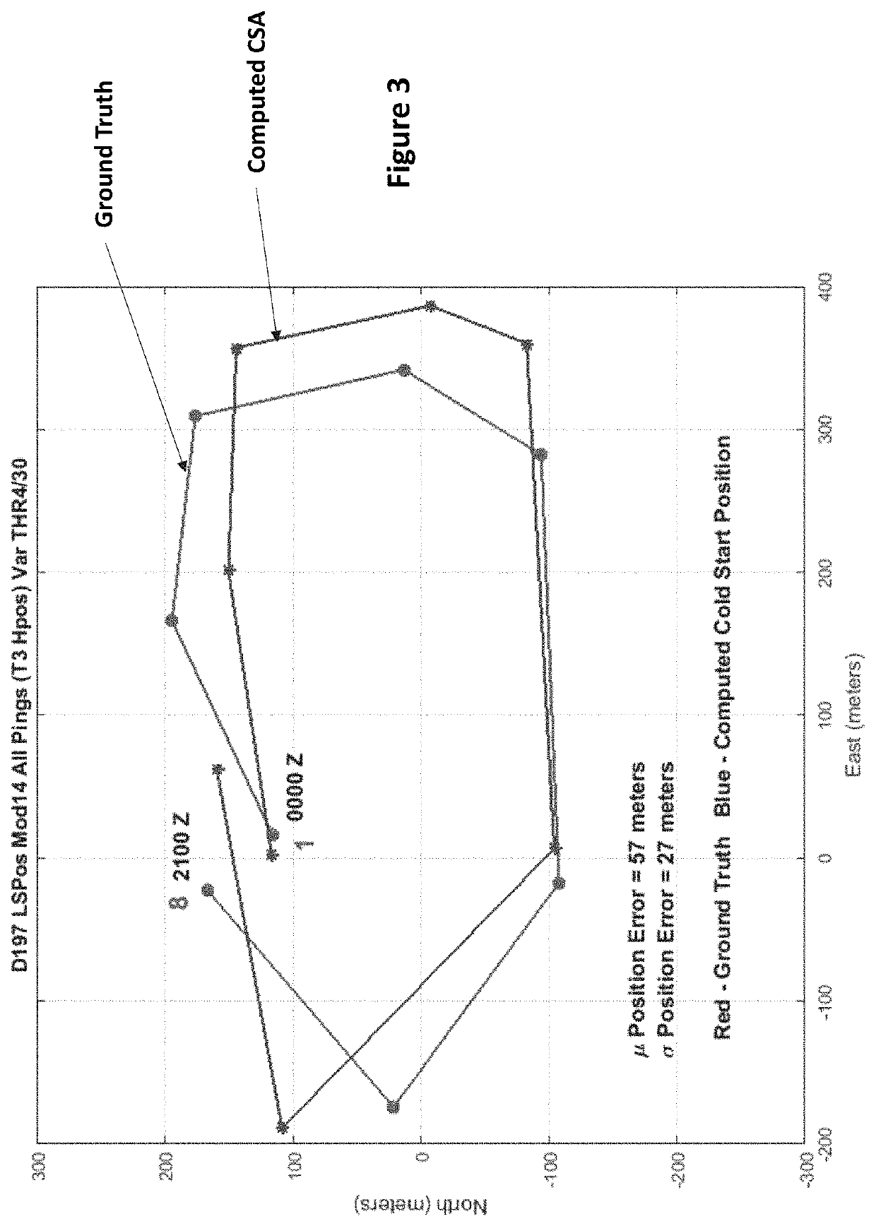
[0003]The embodiments herein are generally directed to navigation of underwater vehicles and more particularly related to determining the geographic position of an underwater vehicle without requiring prior location information as a reference (i.e. surfacing for a GPS position, and without any information about the ocean sound speed in the area of operation).

Description of Related Art

[0004]Improving underwater navigation of undersea vehicles is an ever-evolving field of study and has become increasingly important with the development and expanded use of Autonomous Underwater Vehicles (AUVs), underwater buoyancy gliders, and subsurface scientific floats. Underwater vehicles are critical to defense, scientific ocean research, and deep-sea exploration, e.g., for mining, and oil and gas. Currently, navigation of underwater vehicles relies on GPS (see below) and is carried out over short ranges (approximately 10 km) at specific ocean areas of interest with bottom mounted and ship mounted...


PUM


Abstract

An underwater navigation algorithm (UNA) uses acoustic signals transmitted in the ocean from sources at known positions to compute a position underwater for a vehicle that requires no initial a priori position or any ocean sound speed information or any initial GPS position that would require surfacing. The UNA consists of two parts, (1) the Cold Start Algorithm (CSA) and (2) the CSA with Modeling (CSAM). The underwater vehicle needs to be equipped with only a single hydrophone acoustic receiver and an onboard processor. The CSA requires only measuring the travel time of the end of the arrival coda (EOC) from each of the sources to compute a position. The CSAM is a post CSA procedure to calculate a higher accuracy position using the CSA position. CSAM utilizes the CSA position and a 4D sound speed field derived from an ocean 4D General Circulation Model (GCM) constrained using Ocean Acoustic Tomography (OAT) in the ocean area of operation and further includes (1) computing a modeled result with an acoustic propagation modeling code that is compared with the received acoustic data using a known procedure called “bulk shifting” and / or (2) a new proposed procedure that uses calculated group speeds from the 4D sound speed field, to provide a higher accuracy estimate of the receiver position.

Description

CROSS REFERENCE TO RELATED APPLICATIONS[0001]The present application claims the benefit of priority to U.S. Provisional Patent Application No. 62 / 417,738 directed to Deep Ocean Long Range Underwater Navigation Algorithm (UNA) For Determining the Geographic Position of Underwater Vehicles, filed on Nov. 4, 2016, the entirety of which is incorporated herein by reference.COMPUTER PROGRAM LISTINGS[0002]Computer program listings, Listing A UNA_MATLAB_EOC_TraveTime_Detection Program) and Listing B UNA_MATLAB_COLD_START_LEAST_SQUARES_POSITION_PROGRAM), are included herein at the end of the Detailed Description.BACKGROUNDField of the Embodiments[0003]The embodiments herein are generally directed to navigation of underwater vehicles and more particularly related to determining the geographic position of an underwater vehicle without requiring prior location information as a reference (i.e. surfacing for a GPS position, and without any information about the ocean sound speed in the area of op...

Claims


Application Information

Patent Timeline
Patent Type & Authority Patents(United States)
IPC IPC(8): G01S5/22G06F30/20
CPCG01S5/22G06F30/20G01S5/30
Inventor MIKHALEVSKY, PETER N.
Owner LEIDOS
Learn More