Method and system for processing positioning signals in a stand-alone mode

a positioning signal and standalone technology, applied in the field of geolocation, can solve the problems of increasing the weakened satellite signal, the relatively expensive requirement of the integration of the network of such receivers, etc., and achieve the effects of minimizing the time to estimate the pseudorange of received positioning signals, reducing disadvantages and problems, and maximizing processing gains

Inactive Publication Date: 2005-02-17
FAST LOCATION NET
View PDF91 Cites 12 Cited by
  • Summary
  • Abstract
  • Description
  • Claims
  • Application Information

AI Technical Summary

Benefits of technology

[0009] The present invention provides an improved method and system for processing positioning signals in a stand-alone mode. This invention substantially eliminates or reduces disadvantages and problems associated with previous systems and methods. In a particular embodiment, the time to estimate a pseudorange from received positioning signals is minimized, while the processing gain is maximized to facilitate rapid detection of positioning signals while minimizing the consumption of energy.
[0011] Technical advantages of one or more embodiments of the present invention include providing an improved method for processing positioning signals in a stand-alone mode. In particular, the time required to obtain pseudorange estimates from weakened positioning signals is minimized and the processing gain available in any sample segment used to obtain pseudorange information is maximized. In addition, by using a direct extraction method to quickly determine a CFO, resolving the identity of satellites whose signals are being received, and compensating the received signal by the amount of the CFO, the pseudorange estimation may be accomplished without performing a time-consuming search through the Doppler frequencies and satellite codes.
[0012] Other technical advantages of one or more embodiments of the present invention include a geolocation processor that may supply, to a receiver, current fragments of message data that were transmitted during the time the receiver was collecting signal samples. This is possible because the geolocation processor and the receiver are able to exchange time-of-day synchronizing information. As a result, the modulation for the message data may be removed from the samples being processed by the receiver. Accordingly, the available processing gain that can be achieved from a signal averaging process is maximized.
[0013] Due to the improvement in processing gain, technical advantages of one or more embodiments of the present invention also include an ability either to obtain greater sensitivity in a given amount of signal processing time or to significantly reduce the amount of processing time to reach a particular level of sensitivity. In this regard, a dynamic process is used that acquires only the amount of signal necessary to achieve reliable detection. This minimizes both the processing time and the amount of intermediate-result memory storage required during signal processing.
[0014] Yet another technical advantage of one or more embodiments of the present invention includes the removal of a requirement to integrate a geolocation processing system with the wireless carrier network that provides a communication link between the ranging receiver and an assisting function. Thus, the need for, and the costs associated with, a wireless carrier or plain old telephone system network are eliminated. For example, support from a carrier's network is not required to determine a coarse position estimation. In addition, a support network of nearby reference receivers, or its equivalent, is not required to provide Doppler-shift compensation or Doppler-shift search assistance. An end-to-end frequency-calibration embodiment in the wireless communication link between the receiver and the geolocation processor to allow making use of the Doppler-shift is also not required.
[0015] In addition, technical advantages of one or more embodiments of the present invention include minimized memory use, power consumption and network loading, increased sensitivity, decreased amount of time for a location estimate, and greater privacy for customers.

Problems solved by technology

When satellite signals are received at wireless devices being operated with obstructed views of the sky and thus obstructed line-of-sight, the satellite signals are weakened even further.
Disadvantages associated with this example include a relatively expensive requirement of integration of the network of such receivers with the wireless carrier network that provides a link between the unknown location and the unobstructed receivers.
In addition, this solution restricts the joint operation of the unknown location and the unobstructed receivers in performing the geolocation processing functions to only those carrier networks that are so integrated.

Method used


Image

  • Method and system for processing positioning signals in a stand-alone mode
  • Method and system for processing positioning signals in a stand-alone mode
  • Method and system for processing positioning signals in a stand-alone mode

Examples


Embodiment Construction

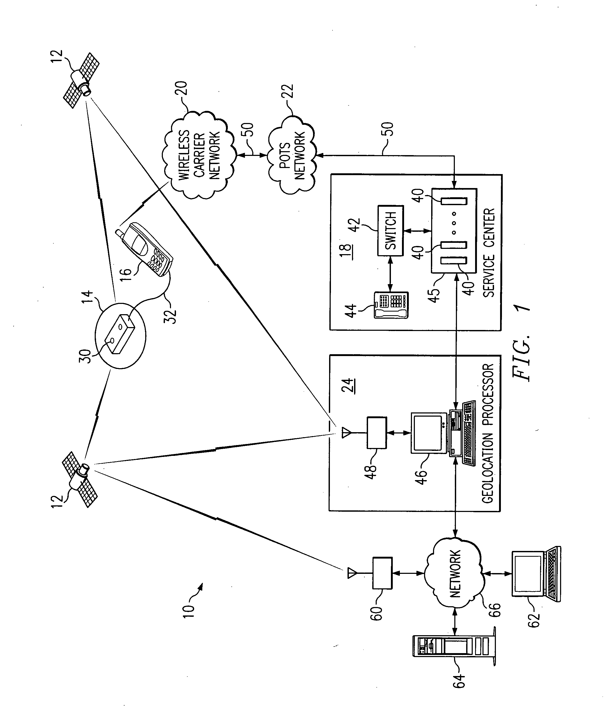
[0033]FIG. 1 is a block diagram illustrating a remote geolocation system 10 in accordance with one embodiment of the present invention. The system 10 may comprise a global positioning system (GPS), a global navigation satellite system (GLONASS), or other suitable navigation system.

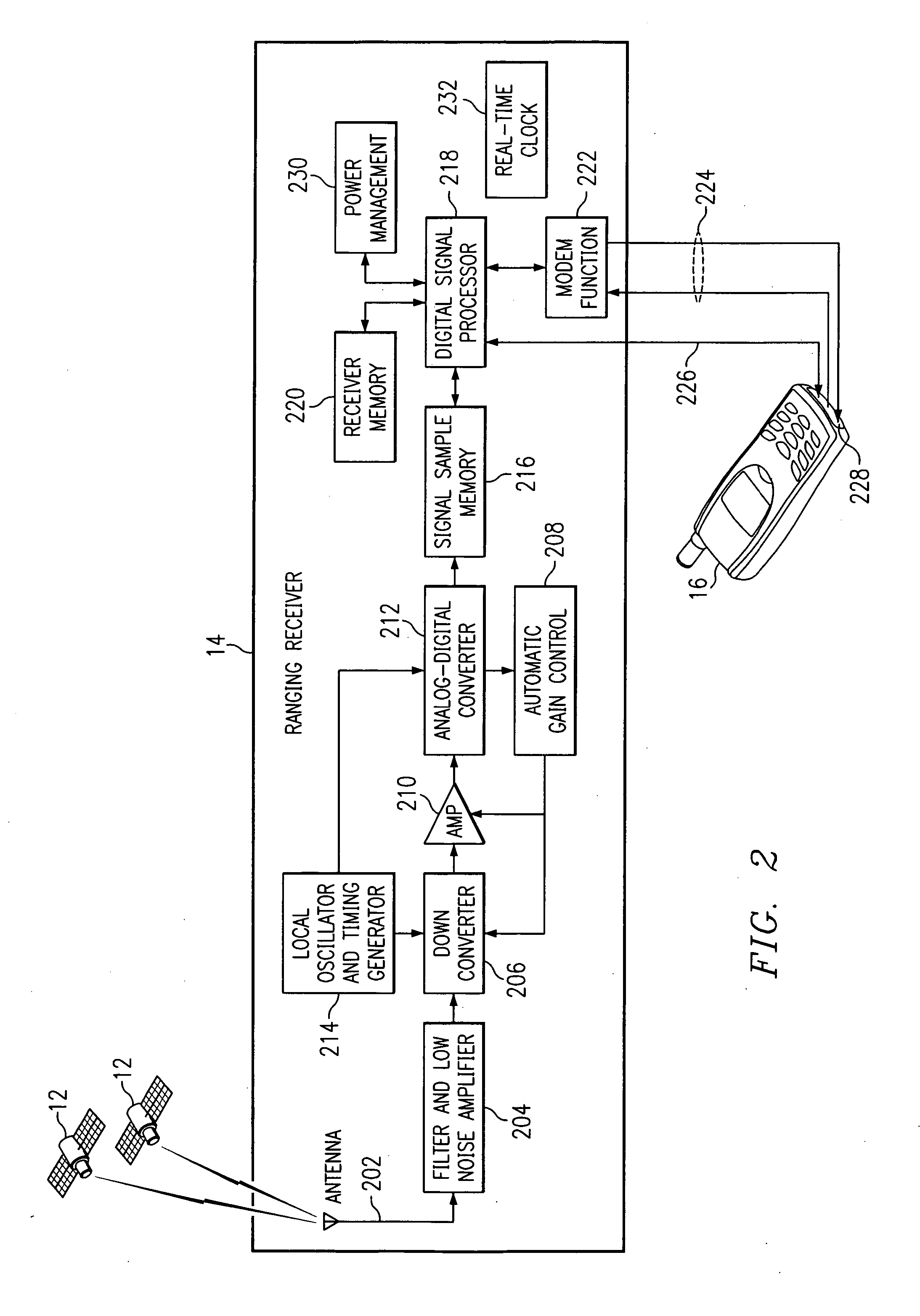
[0034] In the case of GPS, satellites in a navigation constellation all transmit on the same 1575.42 MHz frequency and use a code division multiple access (CDMA) technique to distinguish one satellite's signal from the others. In the case of the GPS constellation, a 1023-chip Gold code is biphase-modulated on the sinusoidal carrier. The Gold codes, unique to each satellite, are used for the CDMA and ranging functions. The chipping rate in this case is 1023 kHz, so that the transmission of the Gold Code repeats every millisecond. One cycle through the Gold Code is called a “code epoch.” A set of samples whose duration is equal to the duration of a code epoch is referred to herein as an epoch. Navigation me...


PUM


Abstract

A method for processing positioning signals in a ranging receiver in a stand-alone mode is provided. The method includes collecting pseudorange samples from positioning signals received at the ranging receiver from a plurality of satellites. The pseudorange samples comprise message data modulation. Each satellite has an associated Gold code. A previously determined carrier frequency offset (CFO) is selected from a plurality of directly extracted CFOs. The pseudorange samples are compensated for the selected CFO. The message data modulation is removed from the pseudorange samples. The pseudorange samples are stacked for each satellite. The Gold code associated with each satellite is correlated to generate a pseudorange time sequence for the satellite. A determination is made regarding whether an adequate correlation peak exists in each pseudorange time sequence. A pseudorange is determined for the ranging receiver based on the correlation peaks when an adequate correlation peak exists in each pseudorange time sequence.

Description

RELATED APPLICATIONS [0001] This application is a divisional of U.S. patent application Ser. No. 09 / 908,011, filed Jul. 18, 2001 by Louis Henry Martin Jandrell and ENTITLED “METHOD AND SYSTEM FOR PROCESSING POSITIONING SIGNALS IN A STAND-ALONE MODE.”[0002] This application is related to copending U.S. patent application Ser. No. 09 / 909,274, filed Jul. 18, 2001, entitled “METHOD AND SYSTEM FOR PROCESSING POSITIONING SIGNALS WITH MATCHING ASSISTANCE” (Attorney's Docket 068796.0102); copending U.S. patent application Ser. No. 09 / 908,403, filed Jul. 18, 2001, entitled “METHOD AND SYSTEM FOR PROCESSING POSITIONING SIGNALS IN A GEOMETRIC MODE,” now U.S. Pat. No. 6,515,620 B1 issued Feb. 4, 2003 (Attorney's Docket 068796.0104); and copending U.S. patent application Ser. No. 09 / 908,199, filed Jul. 18, 2001, entitled “METHOD AND SYSTEM FOR DETERMINING CARRIER FREQUENCY OFFSETS FOR POSITIONING SIGNALS,” now U.S. Pat. No. 6,529,160 B2 issued Mar. 4, 2003 (Attorney's Docket 068796.0105).TECHNIC...

Claims


Application Information

Patent Timeline
Patent Type & Authority Applications(United States)
IPC IPC(8): G01S19/25G01S1/00G01S5/00G01S19/06G01S19/46
CPCG01S5/0018G01S5/0063G01S19/05G01S19/09G01S19/17G01S19/235G01S2205/008G01S19/256G01S19/258G01S19/29G01S19/34G01S19/35G01S19/254
Inventor JANDRELL, LOUIS HENRY MARTIN
Owner FAST LOCATION NET
Why Eureka
Try Eureka