Asset tracking method

a technology of asset tracking and tracking method, applied in the direction of road vehicle traffic control, measurement device, instruments, etc., can solve the problems of multipath reception, noise, ionization of the earth's atmosphere and clock skew, and the need for providing higher accuracy levels, so as to improve the accuracy of positioning. , the effect of improving the accuracy of positioning

Inactive Publication Date: 2006-02-02
PRECO ELECTRONICS INC AN IDAHO
View PDF11 Cites 29 Cited by
  • Summary
  • Abstract
  • Description
  • Claims
  • Application Information

AI Technical Summary

Benefits of technology

[0013] The reference receiver receives the same GPS signals as the other receivers, and it uses its known position to calculate timing. It calculates what the travel time of the GPS signals should be, compares them to what they actually are, and then transmits differential corrections to the fixed local devices, in order to correct their measurement. Since the reference receiver doesn't know which of the many available satellites a fixed local receiver might be using to calculate is position, the reference receiver computes errors for all visible satellites. With DGPS, fixed local receivers apply the differential corrections to the particular satellite data they are using, based on this correction information sent from the reference location. A DGPS reference receiver can also use carrier measurements and pseudorange data to provide even greater accuracy to fixed local devices or to third parties. These can be used to further improve position accuracy through differential carrier positioning methods.
[0014] The present invention is a system and a method of providing accurate, DGPS corrected asset location data. This invention comprises a system that is easy to install and use, and, as described above, may be provided at a lower cost than other location management systems found commercially or in the prior art. According to the present invention, a GPS equipped mobile device determines its location and communicates it to a fixed local device receiver via RF data radio. For typical vehicle or asset management applications, GPS receiver systems from vendors such as SiRF Technology of San Jose, Calif. and Trimble Navigation Limited of Sunnyvale, Calif. are commercially available and are suitable for incorporation into the electronics both for mobile and fixed local devices of the present invention. Communication chip sets for standard data radio protocols, such as 802.11 are also commercially available for low-cost.
[0015] The low-cost GPS receiver used in the mobile and fixed local devices of the present invention provides relatively inaccurate position estimates at a low cost. These uncorrected position estimates are transmitted from the mobile devices to one or more fixed local devices. The fixed local device or devices accumulate data from each of the mobile devices in its managed domain of such devices and forwards on this uncorrected data to one or more reference devices by way of an RF data transmitter. Differential corrections are then applied at the reference location device using the more expensive DGPS receiver, and this corrected data can then be transmitted back to fixed local devices, and / or can be forwarded to third party equipment.

Problems solved by technology

With these systems, there are typically cost constraints associated with providing higher levels of accuracy needed to pinpoint the location of assets to within several meters, which is a requirement for vehicles or assets located close-together, such as in parking lots or equipment yards.
There are a number of errors associated with GPS ranging, including errors due to noise, multipath reception, ionization of the Earth's atmosphere and clock skew.
Therefore, if two receivers are fairly close to each other, the signals that reach both of them will have traveled through virtually the same slice of atmosphere, and will have virtually the same errors.
Since the reference receiver doesn't know which of the many available satellites a fixed local receiver might be using to calculate is position, the reference receiver computes errors for all visible satellites.

Method used


Image

  • Asset tracking method
  • Asset tracking method
  • Asset tracking method

Examples


Embodiment Construction

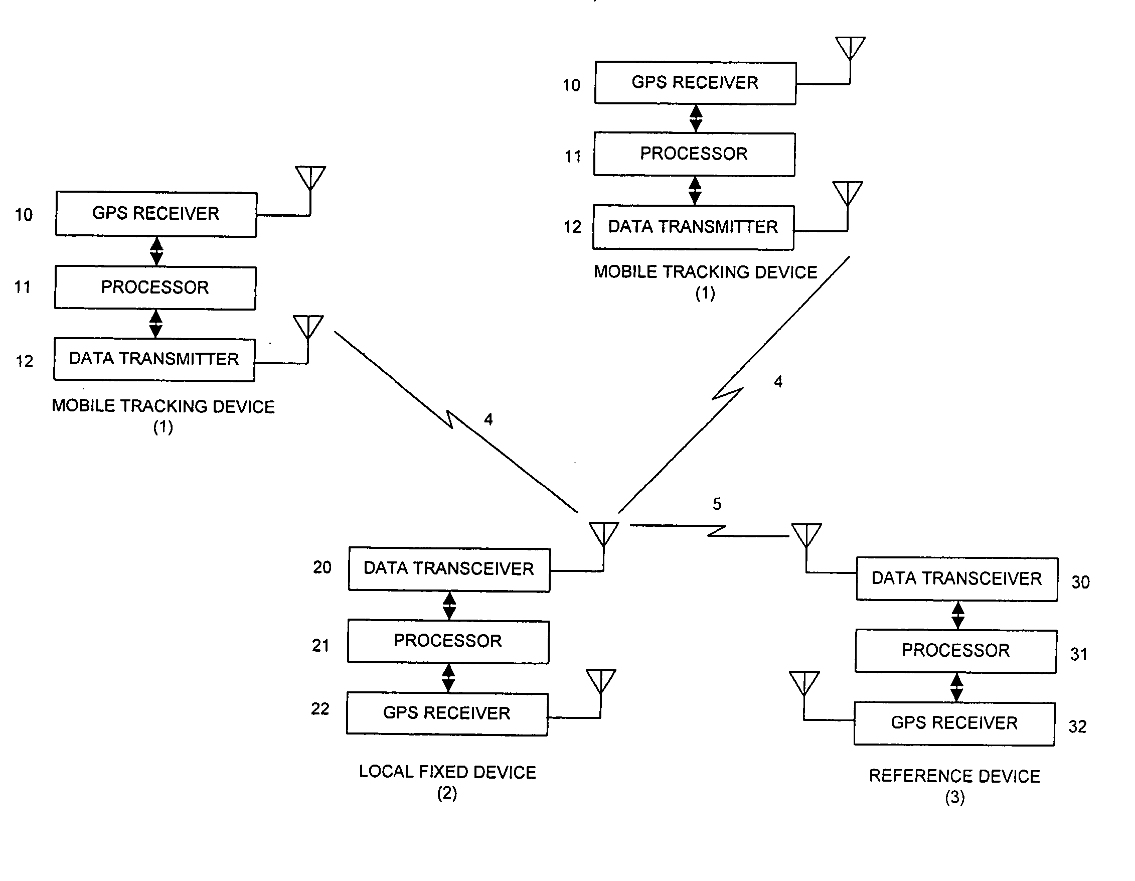
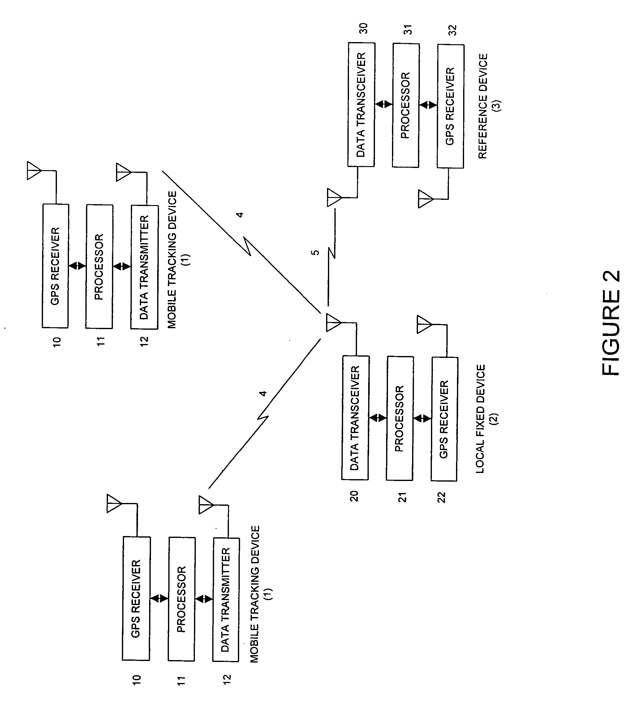
[0029]FIG. 1 is a schematic diagram of one embodiment of the present invention. It depicts a mobile device 1 within a vehicle, a fixed location device 2 within a structure, a reference device 3 within a structure, and a set of positioning system satellites 6, which can be NAVSTAR GPS satellites or satellites from an alternate positioning system. Radio waves are depicted between the positioning system satellites 6 and ground receivers 1, 2 and 3 as rays a1, a2, b1, b2, c1, c2, d1, d2, e1, and e2. Radio path 4 is a uni-directional path from any mobile device 1 to a fixed location device 2. Radio path 5 is a bi-directional path between fixed location device 2 and reference device 3. Typically, a fixed location device 2 is located within close proximity to the mobile devices 1 that are being tracked. Reference device 3 can be located remotely from fixed location devices 2. A precise geographical reference location must be known by reference device 3, so that it has the capability of per...


PUM


Abstract

The present invention relates to a system for managing assets such as vehicles and/or equipment in an area such as a repair yard or parking lot. A plurality of mobile devices periodically wake-up at different times and transmit their uncorrected GPS location data to one or more fixed local devices. Each fixed local device periodically forwards its accumulated, uncorrected GPS data for each mobile device to a reference device. A reference device is precisely located and capable of differentially correcting the data and forwarding the corrected result sets either back to the local devices and/or to third parties.

Description

BACKGROUND OF THE INVENTION [0001] 1. Field of the Invention [0002] This invention relates to location tracking systems for fleets of vehicles, heavy equipment or other moveable assets. [0003] 2. Related Art. [0004] The NAVSTAR Global Positioning System (GPS), developed and implemented by the U.S. Department of Defense, uses position and time information broadcast from a constellation of up to 24 satellites, moving in non-geosynchronous orbits, to allow determination of the present time, observer location and velocity adjacent to the Earth's surface. In many different applications of use of this information, there have been systems developed for tracking vehicle position, monitoring of fleet vehicle routing and for providing navigation information to drivers. None of the previous inventions or products that are known in the art or commercially, however, provide the features of the present invention. This invention provides benefits as a low-cost inventory and asset tracking system, ...

Claims


Application Information

Patent Timeline
Patent Type & Authority Applications(United States)
IPC IPC(8): G01S5/14G01S19/27
CPCG01S5/0027G01S19/07G08G1/20G01S2205/002G01S19/41G01S19/071G01S19/072
Inventor HESSING, DALE
Owner PRECO ELECTRONICS INC AN IDAHO
Why Eureka
Try Eureka