Parking detector - a system and method for detecting and navigating to empty parking spaces utilizing a cellular phone application

a technology of parking detector and cellular phone application, applied in the direction of road vehicle traffic control, vehicle components, instruments, etc., can solve the problems of driver still, vehicle operator on a fruitless quest, prior art systems of only limited help to vehicle operators

Inactive Publication Date: 2006-11-30
MENDELSON EHUD
View PDF17 Cites 195 Cited by
  • Summary
  • Abstract
  • Description
  • Claims
  • Application Information

AI Technical Summary

Benefits of technology

[0117] Each circular line represents 50 feet in distance from the user's car. This makes it easy for the user to determine the distance to the parking space.
[0118] The ability to operate our innovation using our application on a cellular phone, the Parking Detector, with no need for cellular connection, or on any stand alone Bluetooth enabled device, means the user does not need a built-in navigation system in the car.

Problems solved by technology

However, because the driver seeing a parking available signal is not advised of the number and specific location of parking spaces that are available in that block, the vehicle operator may proceed to the indicated location to find that a single available space has already been occupied or that the space will not accommodate his vehicle.
In either situation, the binary availability signal may lead the vehicle operator on a fruitless quest.
Unfortunately, such systems again only yield a binary yes or no signal to the drivers.
Even if an area contains only one available space, even if the space is obstructed, will not accommodate the driver's car, or is otherwise undesirable, a driver still will be lead to that area.
These prior art systems are of only limited help to vehicle operators and do not resolve many concerns associated with parking an automobile.
This vehicle navigational system patent does not address the problem of locating available on-street parking.
Parking lots in congested city areas are not very cost effective, and they may not be in close proximity to the driver's destination.
Because the technique described operates over a wireline medium, it does not lend itself to being easily deployed in a wide area.
Also, because parking information is never provided to any device within a vehicle, drivers still need to navigate through a garage to locate available spaces.
At present, there is no on-board vehicle navigational system that delivers accurate and real time parking space information directly from the vehicle or ether portable phone application upon entering a specific geographic area.
Schreder does not disclose sub-meter vehicle location accuracy determination
However, it is unclear as to whether the second position system is actually more accurate than the GPS system.
This combined system, however, cannot be used for sub-meter positioning of an automobile.
This procedure does not give sub-meter accuracy.
Locating a vacant parking space is an ordeal that causes frustration for many commuters.
Even if a commuter pays to enter a parking lot, valuable time is consumed searching for a parking space within the parking lot.
It seems that parking lots that service hospitals, airports, mass transit stations, entertainment forums, shopping malls and the like are always the most crowded, when time is the most crucial.
As urban and suburban regions become more populated, finding a vacant parking space will become increasingly difficult for commuters.
At present, however, no prior art device utilizes the capabilities to display a real-time representation of available parking spaces directly from the sensors without a central system; and without using a GPS based system directly to the “user” driver.
All impractical while driving in traffic.
And the existing mapping that these systems use has the same limitations described previously and is impractical.
A system that requires a driver to interface with the internet can only be used for remote planning and not while a driver is navigating through traffic and looking for a parking space.
Other parking projects exist but they do not approach our innovation in ability to deliver a complete solution to the parking problem.
Other projects address the issue from the perspective of a parking garage and do not consider street parking, nor are they really concerned to facilitate the location of an empty space inside their garage.
They do not provide the driver with the ability to compare prices in the vicinity.
Nor do other projects contemplate the concept of a parking detector with a direct communication between the sensors and the “user” driver in real-time.
Yet, it is considerably more complex to implement, as it requires a modification to the hardware on the mobile side, as well as special modifications on the antenna side.
AOA is considerably less accurate than TOA, due to limited angular resolution and the fact that indoor much of the signal is reflected.
Also, AOA antennas are more complex, as they require multi-section, highly directional antennas, and multiple RF circuitry.
One limitation of such systems is the fact that WLAN tags are relatively bulky and power hungry.

Method used


Image

  • Parking detector - a system and method for detecting and navigating to empty parking spaces utilizing a cellular phone application
  • Parking detector - a system and method for detecting and navigating to empty parking spaces utilizing a cellular phone application
  • Parking detector - a system and method for detecting and navigating to empty parking spaces utilizing a cellular phone application

Examples


Embodiment Construction

[0131] In all the figures of the drawings, sub-features and integral parts that correspond to one another bear the same reference symbol.

[0132] Referring now to the drawings in detail and first particularly to FIGS. 1-5 thereof.

[0133] These figures illustrate the method and system to detect and navigate to empty parking spaces utilizing our application on a cellular phone.

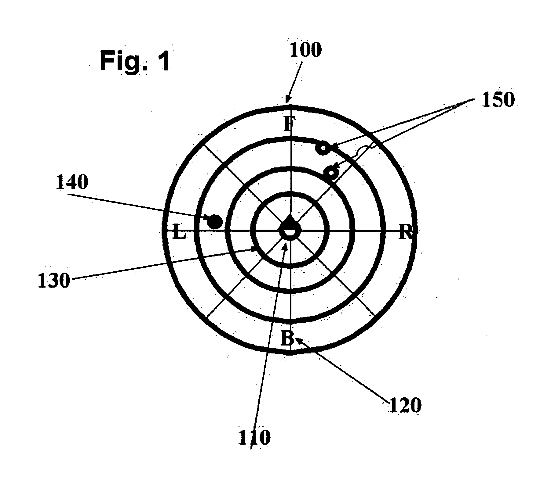
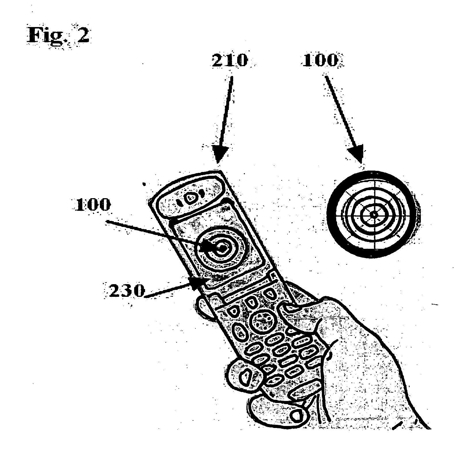
[0134] Referring to FIG. 1 This shows the real-time floating overlay omni-directional circular display, 100. This feature is superior to the GPS based systems and the existing mapping systems that are only accurate to within several hundred feet.

[0135] The user will have easy way to determine the distance and the direction to the available parking spaces without GPS or any mapping.

[0136] The available parking spaces will be displayed inside the graphical real-time omni-directional circular display in such way that the user will intuitively determine the distance and the direction to the empty parking spaces.

[...


PUM


Abstract

The parking detection system method described herein could guide people around urban environments, detect guide and navigate them to empty parking spaces, add-on to the car-based navigation systems that are popular today and or to the portable phone. We have focused on the task of detecting and navigating even in situations in which Global Positioning Systems (GPS) cannot provide this information, such as when the person is indoors or in crowded urban areas where there is no line of site to the GPS satellites. The parking information will be received directly from RF sensors and will display as a floating overlay on the existing cellular phone as Bluetooth application making the cellular phone a parking detector.

Description

FIELD OF THE INVENTION [0001] This invention is directed generally to the field of “location based navigation” and, more particularly, to such method to be used in a cellular phone wireless application for detecting and navigating to empty, available parking spaces. BACKGROUND OF THE INVENTION Introduction to Location Based Services: [0002] Location based services are rapidly expanding. Outdoor location technologies are mainly based on GPS technologies. GPS does not perform properly indoors, and is not adequate. Recently, as a result, indoor location systems are appearing on the market. [0003] The need for a system such as ours arises from various market segments and applications. One example in the market is the “Car Navigator” that uses integrated positioning and navigation systems based on GPS receivers as the primary positioning technology. Subsequent to the events of September 11th the Federal government mandated that GPS capability be built in to all cellular phones. [0004] H...

Claims


Application Information

Patent Timeline
Patent Type & Authority Applications(United States)
IPC IPC(8): G08G1/14
CPCG08G1/14
Inventor MENDELSON, EHUD
Owner MENDELSON EHUD
Why Eureka
Try Eureka