System for associating pre-recorded images with routing information in a navigation system

a navigation system and pre-recorded image technology, applied in surveying and navigation, navigation instruments, instruments, etc., can solve the problems of driver confusion, inaccurate distances, poor lighting, etc., and achieve the effect of fewer wrong turns, fewer missed turns, and greater success

Inactive Publication Date: 2007-03-08
FACET TECH LLC
View PDF20 Cites 123 Cited by
  • Summary
  • Abstract
  • Description
  • Claims
  • Application Information

AI Technical Summary

Benefits of technology

[0015] The present invention allows drivers in the process of following destination directions from a navigation system to have greater success (make fewer wrong turns and have fewer missed turns) and create safer roadways by having access to landmark images. For every intersection where a driver action is required, for example, the present invention can provide the driver with a near, intermediate, and far image of the approaching intersection. Since a simple crossing of two roads has four possible views of the intersection (corresponding to the four directions of vehicle travel), the present invention can produce the images that are relevant to the perspective of the vehicles proposed direction of travel. Drivers are thus able to compare the intersection images with their upcoming views of the actual roadway to acquaint themselves with the intersection and determine proper actions to be taken at that intersection.
[0016] In a preferred embodiment, users can experience virtual travel from a source point to a destination. Systems that provide turn-by-turn directions from a routable network of roadways are well known. These systems can be further enhanced by allowing users to “see” the actual route specified by the routing software by showing the sequence of landmark images along the described route that are associated with given spatial nodes.
[0017] This invention describes a collection and presentation method of actual imagery from roadways in such a way that centralized and co-located image repositories can rapidly display landmark images along defined navigation routes. By selectively associating the landmark images with pre-processed header information, the present invention permits the landmark images to be decoupled from the navigation route information. The decoupled information approach permits rapid updating and distribution of image information for use on various clients, including light clients like cell phones, personal digital assistants (PDAs), and satellite radios. Furthermore, the decoupled approach to vehicle navigation of the present invention allows for better utilization of the limited-bandwidth network connections available to on-board navigation systems.
[0018] In a preferred embodiment, off-board users can further acquaint themselves with critical information regarding a navigation route. For example, a potential buyer of residential real estate can utilize an Internet-based system to view potential properties. In conjunction with this system, images of all roadways can be provided to the user. If, for example, the user wanted to explore the route their children would traverse from the target property to their elementary school, the user could define the origin as the target property, define the destination as the elementary school, and allow the application to take the user on a virtual walk to the school.
[0019] In a preferred embodiment, the rate at which the landmark images are displayed can be easily changed. If, for example, a user wanted to make a very rapid pass over a desired route, the application can make adjustments to the image stream in order to best use the available bandwidth over the network. The application could display only selective images along the route, thus allowing the user to move through the route at a faster rate. Alternatively, the application could access more highly compressed versions of the images. While highly compressed images exhibit somewhat diminished image quality, users moving through the imagery at higher rates of speed would not notice the image degradation.

Problems solved by technology

Off-board navigation systems, such as Internet-based direction programs like MapQuest® or standalone direction programs available in many vehicles often can only produce a displayed map showing the route on a map and listing the specific actions to be taken by the driver at certain intersections.
Often times, however, these distances are not accurate enough for precise location of the intersection by the driver.
Conditions like heavy traffic, multiple intersection choices, commercial sign clutter, and poor lighting can contribute to driver confusion at key decision points.
Route planning features of navigation systems can usually give good instructions for drivers, but the visual route information can only be plotted on a two-dimensional road map.
Drivers are often unfamiliar with the terrain being navigated while following directions.
It is also difficult to show foliage, signage, lighting structures, and other visual cues that might assist in driver navigation on a two-dimensional road map.
The bandwidth limitations of on-board navigation systems have made image usage a difficult problem to solve.

Method used


Image

  • System for associating pre-recorded images with routing information in a navigation system
  • System for associating pre-recorded images with routing information in a navigation system
  • System for associating pre-recorded images with routing information in a navigation system

Examples


Embodiment Construction

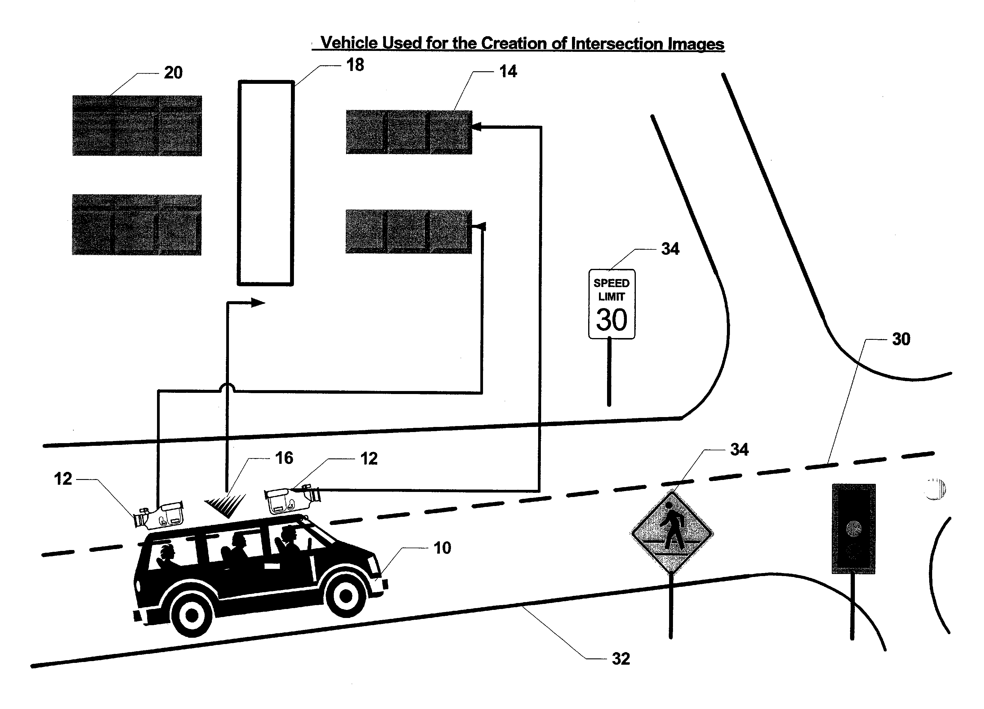
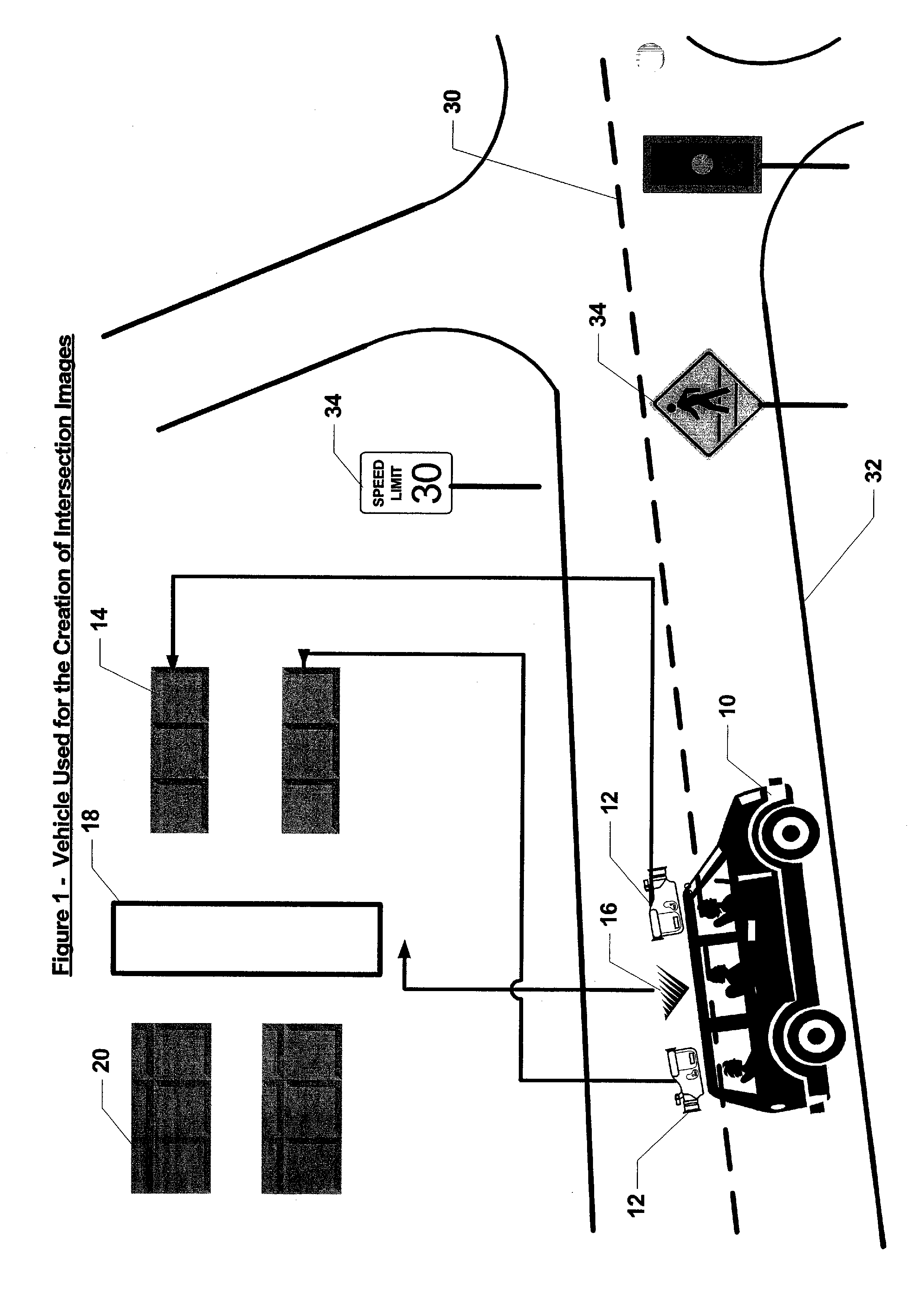
[0035] Referring to FIG. 1, a preferred embodiment for how images are obtained and processed as part of the present invention will be described. An acquisition vehicle 10 equipped with one or more cameras 12 generates a series of raw image streams 14 representative of a road or street 32 over which the acquisition vehicle 10 is traveling. For each portion of a roadway system being recorded, the acquisition vehicle 10 is preferably driven in both directions along each road or street 32. In the case of road or streets 32 having multiple lanes in the same direction, imagery may be recorded for each lane. This is preferable in the case of separate left and right turn lanes at intersections. In a preferred embodiment, global positioning satellite (GPS) receiver 16 supplies location information that is combined with the raw image stream 14 by a processor 18 to generate a tagged image stream 20. Alternatively, the tagged image stream 20 may be generated using other types of position indica...


PUM


Abstract

A vehicle navigation system uses prerecorded intersection images to more quickly and efficiently acquaint the driver with approaching intersections and other points of interest as part of a navigation system. The pre-recorded images are recorded, selected and processed with header information that associates the selected landmark images of approaching intersections and other points of interest to spatial nodes based on runs defined by routing information in the navigation system. The runs defined by the routing information correlate to a path or road segment to be traveled with the spatial nodes defining a transition point from one run to another, such as a roadway intersection where a turn is required to follow the routing information. Preferably, a multiplicity of recorded images are analyzed from a road segment to select a set of images that correspond to a plurality of distances from an approaching intersection, for example, where the selected images include a view of relevant visual information, such as road sign images, associated with the intersection.

Description

RELATED APPLICATION [0001] The present application claims the benefit of U.S. Provisional Application No. 60 / 707,710, filed Aug. 12, 2005, which is incorporated herein in its entirety by reference.FIELD OF THE INVENTION [0002] The present invention relates generally to the field of data processing and communication systems for route determination and navigation systems utilizing a map database and map display and having audio or visual route guidance or intersection turn guidance. More specifically, the present invention relates to a method and apparatus for using pre-recorded images with pre-processed header information that associates landmark images to spatial nodes based on runs defined by routing information in a navigation system. BACKGROUND OF THE INVENTION [0003] Vehicle navigation systems that can automatically determine driving directions from a starting point to a destination are well known. The typical format of these driving directions is to describe travel along a defi...

Claims


Application Information

Patent Timeline
Patent Type & Authority Applications(United States)
IPC IPC(8): G01C21/00
CPCG01C21/3647
Inventor RETTERATH, JAMIE E.LAUMEYER, ROBERT A.
Owner FACET TECH LLC
Why Eureka
Try Eureka