Field site data gathering and reporting system and method

a field site and data gathering technology, applied in the field of remote data gathering and coordination, can solve the problems of difficult to collect and keep track of all the separate data that is required for a project, large sets of unrelated data, and difficult to move or change old services, etc., to achieve convenient overhead maps and increase accuracy.

Inactive Publication Date: 2008-05-22
UTILITECH SOLUTIONS
View PDF6 Cites 51 Cited by
  • Summary
  • Abstract
  • Description
  • Claims
  • Application Information

AI Technical Summary

Benefits of technology

[0010]Field survey data captured on the handheld device for various features and from various locations can be uploaded into a database at a home or central office location. The data can be post-processed before entry into a project database to assure correctness and to increase accuracy. In particular, GPS data can be made more accurate using differential GPS techniques known in the art, and the field data can be put into forms more convenient for database entry and the GIS system. Aerial photographs can be overlaid with data concerning features and construction to produce convenient overhead maps. Each project feature overlaid on the aerial photograph or map can have a unique identifier and can be auto-linked to the field data and image for that feature. When an engineer wants to retrieve all the data about a particular feature, all that is necessary is to enter its unique identifier and receive back the text data, image data, GPS coordinates, measurements and comments taken in the survey of that feature. In addition to overlaid maps or aerial photographs, reports can be produced relating to all or parts of the project to any level of detail required.

Problems solved by technology

In the utility industry, construction or creation of new services, or moving or changing of old services is particularly site intensive.
It is very difficult to collect and keep track of all the separate data that is required for a project or to manage multiple projects.
Prior art methods, even with PDAs, led to huge sets of unrelated data that later had to be cataloged and entered into a database concerning a project.

Method used


Image

  • Field site data gathering and reporting system and method
  • Field site data gathering and reporting system and method
  • Field site data gathering and reporting system and method

Examples


Embodiment Construction

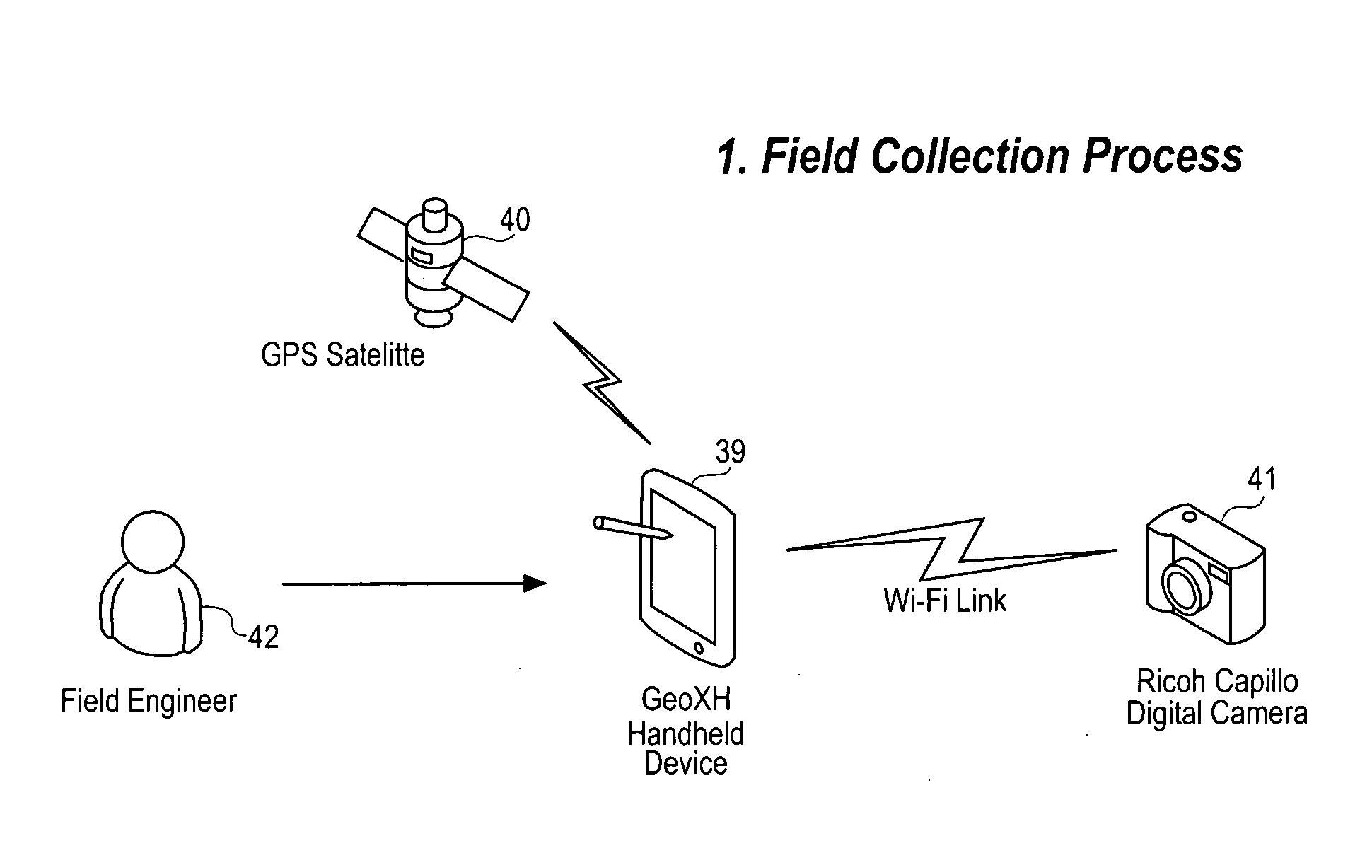
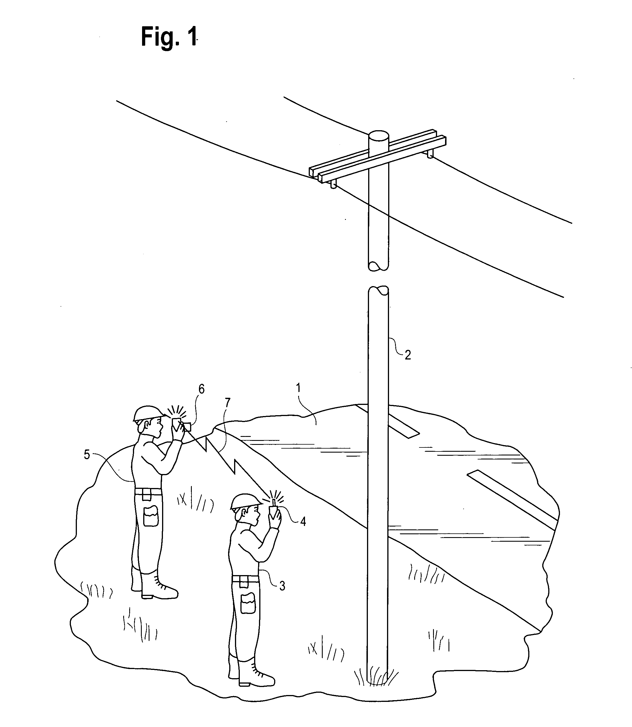
[0021]Remote field site data collection generally involves one or more engineers visiting the location and taking data. The data can be conveniently entered into a handheld device. FIG. 1 shows two field engineers 3, 5 taking a survey at the base of a power pole 2. The first engineer 3 holds a handheld unit 4 that can contain a GPS receiver and a processor with a user interface in the form of keys and a display screen. The second engineer 5 holds a digital camera 6 that can be used to photograph the feature (in this case the pole). The camera 6 can be equipped with wireless capability such as WiFi or Bluetooth so that it can transfer digital images to the handheld unit 4 using a wireless channel 7. This channel can be any form of wireless including radio and light. Common channels known in the art are infrared light, Bluetooth, cellular telephone and WiFi. In the case of cellular telephone and WiFi, the communication can be transferred indirectly through a base station or wireless h...


PUM


Abstract

A system and method of reporting and displaying field survey data related to particular features located at remote sites that includes generating GPS data related to a feature with a handheld device, generating at least one image of the location, entering text data related to the location on the handheld device, and uploading the GPS data, image and text data into a database located at a central location. The photograph can be optionally transferred wirelessly from a camera to the handheld device. In particular, the transfer can be on a wireless network (WiFi). Data can be post-processed at the database location before entry into the database. GIS maps and reports can be made from the processed data for use in a project. These maps and reports can be placed on a web server for access by authorized personnel. The maps can contain an aerial photograph of the remote sites with symbols representing features overlaid on the aerial photograph. Each feature on the map can be linked to the GPS data, image data and text data related to that feature.

Description

BACKGROUND[0001]1. Field of the Invention[0002]The present invention relates generally to remote data gathering and coordination, and more particularly to a field site data gathering and reporting system and method that coordinates and combines data gathered on a plurality of different field features and allows presentation of that data in map format in conjunction with images.[0003]2. Description of the Prior Art[0004]Surveys of electrical power distribution network sites and other remote field sites usually involve several field engineers making one or more personal visits to a site location, logging certain data, taking photographs and then returning to their office with the data in different forms. The data may be subsequently entered into a database to produce maps or reports.[0005]In the utility industry, construction or creation of new services, or moving or changing of old services is particularly site intensive. Each pole, transformer, feeder, and route must be surveyed and...

Claims


Application Information

Patent Timeline
Patent Type & Authority Applications(United States)
IPC IPC(8): G06Q99/00
CPCG01C15/00G06Q50/06G06Q10/06
Inventor OLENSKI, JONDIETZLER, CHRISTOPHER
Owner UTILITECH SOLUTIONS
Why Eureka
Try Eureka