
Method for determining and outputting travel instructions for most fuel-efficient route

Inactive Publication Date: 2008-06-05
IBM CORP
View PDF18 Cites 184 Cited by
  • Summary
  • Abstract
  • Description
  • Claims
  • Application Information

AI Technical Summary

Benefits of technology

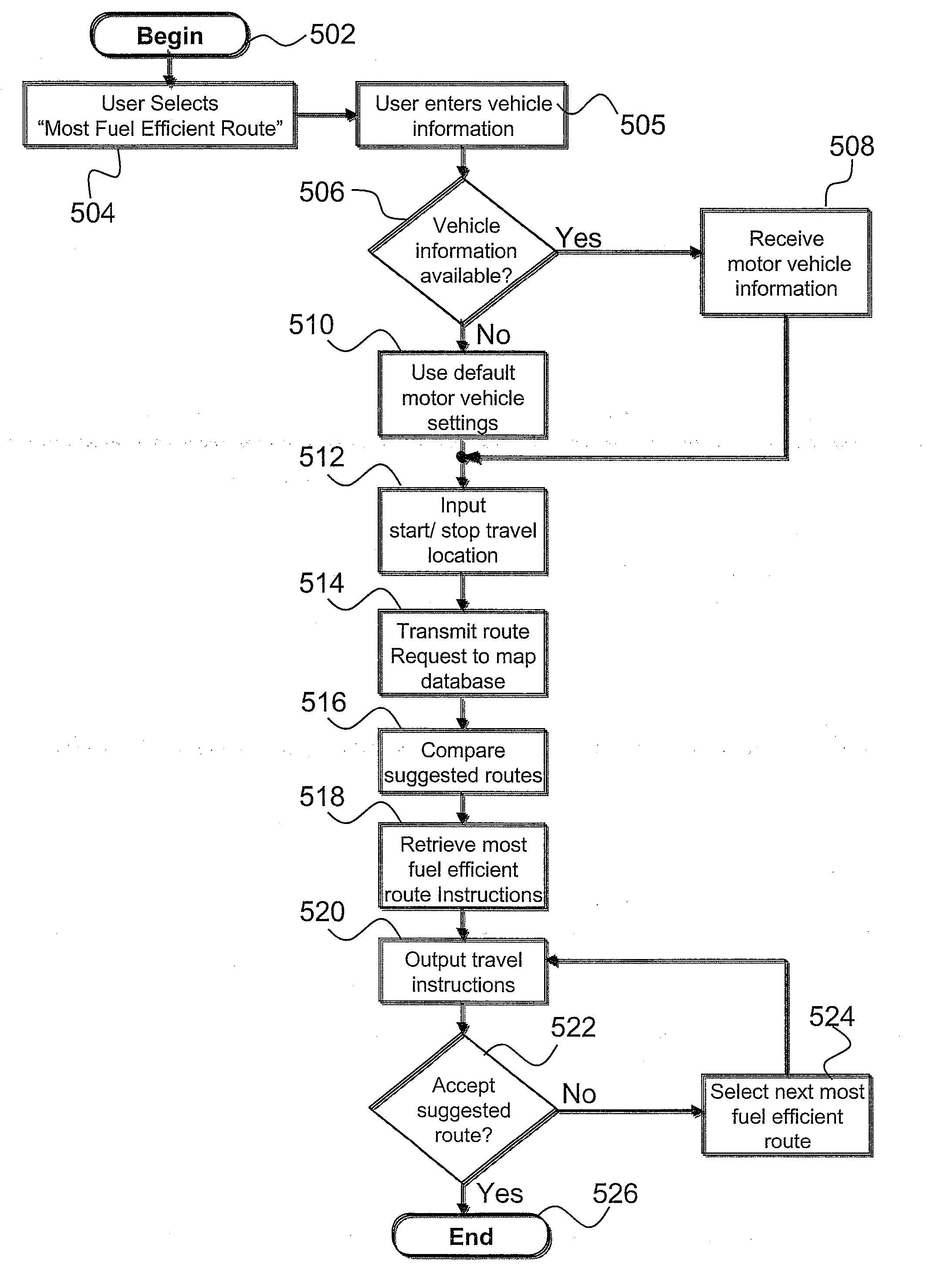
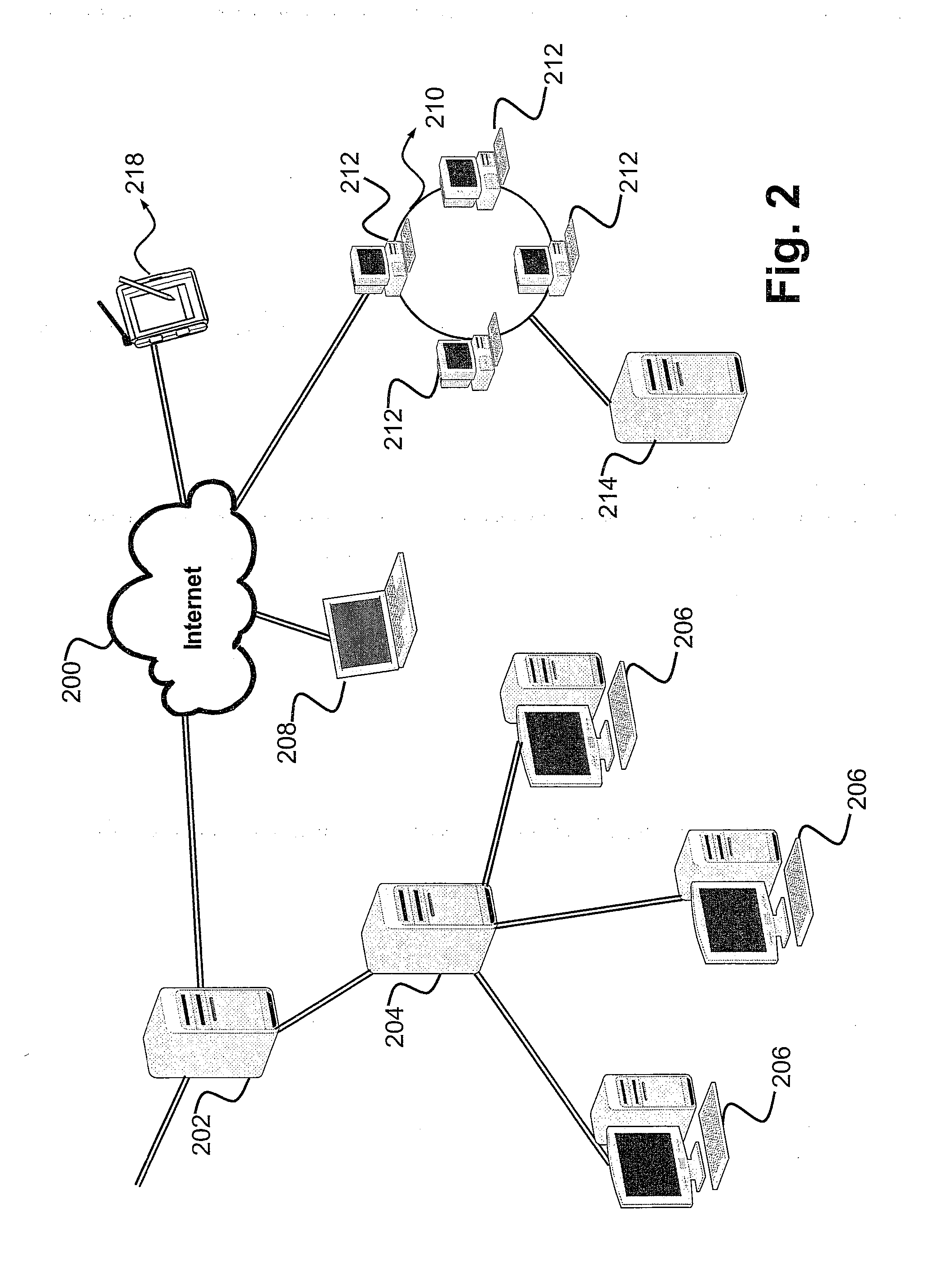
[0013]In another embodiment, the invention provides a method for specifying a destination within a portable navigation apparatus and receiving fuel-efficient route directions. The route planning application is installed in the portable reader such as a palmtop computer, including storage for a map database, and an input / output device for providing a user interface between the portable reader and the operator of the vehicle. Utilizing a client interface, the operator selects the start and stop location. The FER utility accesses the map database and calculates fuel efficiency factoring in user defined vehicle specifications, geography of terrain, and complexity of route. The operator accepts or declines the provided route instructions, or selects the next most fuel-efficient route instructions utilizing the client interface. In this embodiment optional operator feedback of previous and current route fuel usage is available, to increase efficiency of fuel calculations. An advantage of this method is that travel instructions are obtained even if a positioning system, such as a Global Positioning System (GPS) satellite, is out of range, being initialized, or is not available. A server is not required to operate this embodiment of the system.

Problems solved by technology

While this method of route planning has proven to be effective, travelers remain at a disadvantage due to excessive fuel consumption.
The problems associated with fuel consumption are manifold.
Selecting a route based on distance of travel does not ensure efficient fuel usage.
Routes often comprise many traffic signals, stop signs and various terrains that contribute to increased fuel consumption.
Unnecessary or excessive use of vehicles strongly contributes to air pollution resulting in increasing health and environmental problems.
In addition to environmental and health risks associated with increased fuel usage, the consumer suffers financially.
The geography of terrain and complexity of the route are major contributors to fuel consumption.
There is presently no way of effectively providing a fuel-efficient route that a user can select during route planning that considers make, model, year, and fuel type of the motor vehicle.
Additionally, current route planning applications do not evaluate geography of the terrain, frequency of stops, or traffic avoidance to render the most fuel-efficient route.

Method used


Image

  • Method for determining and outputting travel instructions for most fuel-efficient route
  • Method for determining and outputting travel instructions for most fuel-efficient route
  • Method for determining and outputting travel instructions for most fuel-efficient route

Examples


Embodiment Construction

[0024]The present invention provides a method, system, and computer program product for retrieving a sequence of travel instructions that reports fuel-efficient routes calculated with regard to vehicle specifications, geography of terrain, and complexity of travel route. An operator selects the desired starting and ending location via a client interface of a software application. When the user selects “most fuel efficient route,” the fuel-efficient route (FER) utility of the application prompts for entry of the make, model, and year of the operator's vehicle. If the FER utility is embedded in an in-car navigation system, the information about the vehicle characteristics is preprogrammed during installation (e.g., at the factory). The FER utility uses a number of metrics and the vehicle's characteristics, to generate an optimal route for efficient fuel consumption. The invention provides means for an operator of a route planning application to optimize the driving directions for opti...


PUM


Abstract

A method provides a sequence of travel instructions that reports fuel-efficient routes calculated with regard to vehicle specifications, geography of terrain, and complexity of travel route. An operator selects the desired starting and ending location via a client interface of a software application. When the user selects “most fuel efficient route,” the fuel-efficient route (FER) utility of the application prompts for entry of the make, model, and year of the operator's vehicle. If the FER utility is embedded in an in-car navigation system, the information about the vehicle characteristics is preprogrammed during installation (e.g., at the factory). The FER utility uses a number of metrics and the vehicle's characteristics, to generate an optimal route for efficient fuel consumption. The invention provides means for an operator of a route planning application to optimize the driving directions for optimally predicted fuel usage.

Description

BACKGROUND OF THE INVENTION[0001]1. Technical Field[0002]The present invention relates in general to navigational route mapping, and in particular to a method and system for efficiently mapping routes for driving directions. Still more particularly, the present invention relates to a method and system for efficiently mapping routes for driving directions taking fuel usage into account.[0003]2. Description of the Related Art[0004]Navigation software applications are routinely utilized to obtain instructions to and from a user-defined destination. Travel routes are selected according to shortest distance, time of travel, as well as highway and toll access or avoidance. The user defines a starting location, destination, and mode of route. The route guidance unit displays travel instructions according to street and highway names, turns, exits, and distance to travel. The instructions are displayed in order of driving events. While this method of route planning has proven to be effective...

Claims


Application Information

Patent Timeline
IPC IPC(8): G01C21/34G06F17/00
CPCG01C21/3469
Inventor ROMANICK, IAN D.
Owner IBM CORP
Learn More