Navigation device and method

a technology of a navigation device and a menu, applied in the direction of navigation instruments, maps/plans/charts, instruments, etc., can solve the problems of not being able to make corrections, not being able to access menus, and gradually obsolete information

Active Publication Date: 2009-07-09
TOMTOM INT BV
View PDF8 Cites 20 Cited by
  • Summary
  • Abstract
  • Description
  • Claims
  • Application Information

AI Technical Summary

Benefits of technology

[0026]According to the present invention there is provided a method of correcting map data stored on a PND or navigation system, said method including the steps of displaying map data during a navigation or free-driving mode, and characterized in that at least one of a plurality of user-selectable graphical indicators is displayed together with said map data adjacent or overlaid on the particular thoroughfare along which the device is currently traveling, said indicator graphically representing a travel restriction pertinent to one of either

Problems solved by technology

One particular and more pressing requirement for modern PNDs is the need to update and/or correct the map information stored in the memory of the device, as such information becomes gradually obsolete.
While the correction of map data locally in a PND or navigation system is known, as is the subsequent upload of correction data to a centralized server, a primary disadvantage with the correction facility provided on modern PNDs is the need to access

Method used


Image

  • Navigation device and method
  • Navigation device and method
  • Navigation device and method

Examples


Embodiment Construction

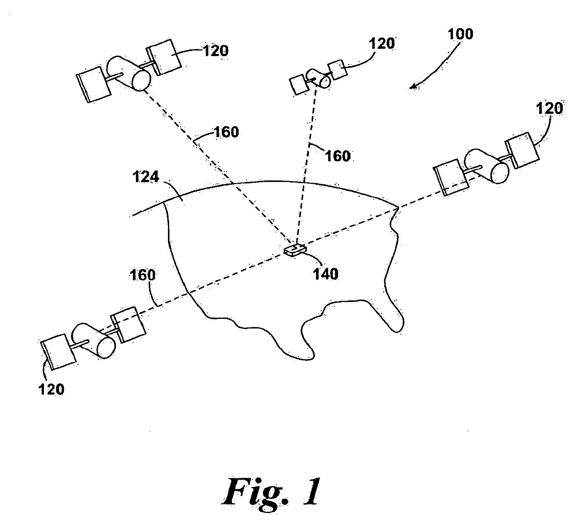
[0042]FIG. 1 illustrates an example view of Global Positioning System (GPS), usable by navigation devices. Such systems are known and are used for a variety of purposes. In general, GPS is a satellite-radio based navigation system capable of determining continuous position, velocity, time, and in some instances direction information for an unlimited number of users. Formerly known as NAVSTAR, the GPS incorporates a plurality of satellites which work with the earth in extremely precise orbits. Based on these precise orbits, GPS satellites can relay their location to any number of receiving units.

[0043]The GPS system is implemented when a device, specially equipped to receive GPS data, begins scanning radio frequencies for GPS satellite signals. Upon receiving a radio signal from a GPS satellite, the device determines the precise location of that satellite via one of a plurality of different conventional methods. The device will continue scanning, in most instances, for signals until ...


PUM


Abstract

A method of correcting map data stored on a portable navigation device or navigation system is described, together with an appropriately enabled device or navigation system. A computer program enabling the method is also described. The method includes the steps of displaying map data on a PND or navigation system during a navigation or free-driving mode, and is characterized in that at least one of a plurality of user-selectable graphical indicators is displayed together with said map data adjacent or overlaid on the particular thoroughfare along which the device is currently traveling, the indicator graphically representing a travel restriction pertinent to one of either the current thoroughfare or a subsequent thoroughfare occurring after a thoroughfare intersection towards which the current thoroughfare leads.

Description

BACKROUND OF THE INVENTION[0001]Portable navigation devices (PNDs) including GPS (Global Positioning System) signal reception and processing means are well known and are widely employed as in-car navigation systems. In essence, modem PNDs comprise:[0002]a processor,[0003]memory (at least one of volatile and non-volatile, and commonly both),[0004]map data stored within said memory,[0005]a software operating system and optionally one or more additional programs executing thereon, to control the functionality of the device and provide various features,[0006]a GPS antenna by which satellite-broadcast signals including location data can be received and subsequently processed to determine a current location of the device,[0007]optionally, electronic gyroscopes and accelerometers which produce signals capable of being processed to determine the current angular and linear acceleration, and in turn, and in conjunction with location information derived from the GPS signal, velocity and relati...

Claims


Application Information

Patent Timeline
IPC IPC(8): G01C21/00G06F3/048
CPCG01C21/32G09B29/106G01C21/3697G01C21/3635G01C21/3856
Inventor THOMASSEN, ERIK
Owner TOMTOM INT BV
Why Eureka
Try Eureka