Method And System For Spatially Resolved Geochemical Characterisation

a geochemical and spatial resolution technology, applied in chemical methods analysis, instruments, geomodelling, etc., can solve the problems of difficult reproduction, time-consuming and labor-intensive pyrolysis measurement, and loss of spatial information regarding the distribution of organic matter

Inactive Publication Date: 2015-11-12
HALLIBURTON ENERGY SERVICES INC
View PDF1 Cites 16 Cited by
  • Summary
  • Abstract
  • Description
  • Claims
  • Application Information

AI Technical Summary

Benefits of technology

[0014]The present invention further relates to a method for determining geochemical information relating to kinetic analysis of a sample, comprising: a) heating at least one sample by laser-induced pyrolysis, such as LIBS; b) monitoring the reaction rate, such as a value of the Arrhenius equation rate constant k, of at least one sample comprising at least one of: i) monitoring changes in amounts of elements associated with organic matter and hydrocarbons for a portion of at least one sample that is heated by the laser-induced pyrolysis, ii) collecting and analysing hydrocarbon species produced by pyrolysis of a portion of at least one sample from the laser-induced pyrolysis by a flame ion detector or gas chromatography-mass spectrometry (GC-MS), iii) monitoring the w

Problems solved by technology

Therefore, any spatial information regarding the distribution of organic matter is lost during the crushing process.
They are also destructive, as the samples cannot be used for further tests after programmed pyrolysis.
Programmed pyrolysis measurements are time intensive, usually requiring about an hour per sample to perform.
The results also can have issues with interference from carbonate in the sample.
This can

Method used


Image

  • Method And System For Spatially Resolved Geochemical Characterisation

Examples


Embodiment Construction

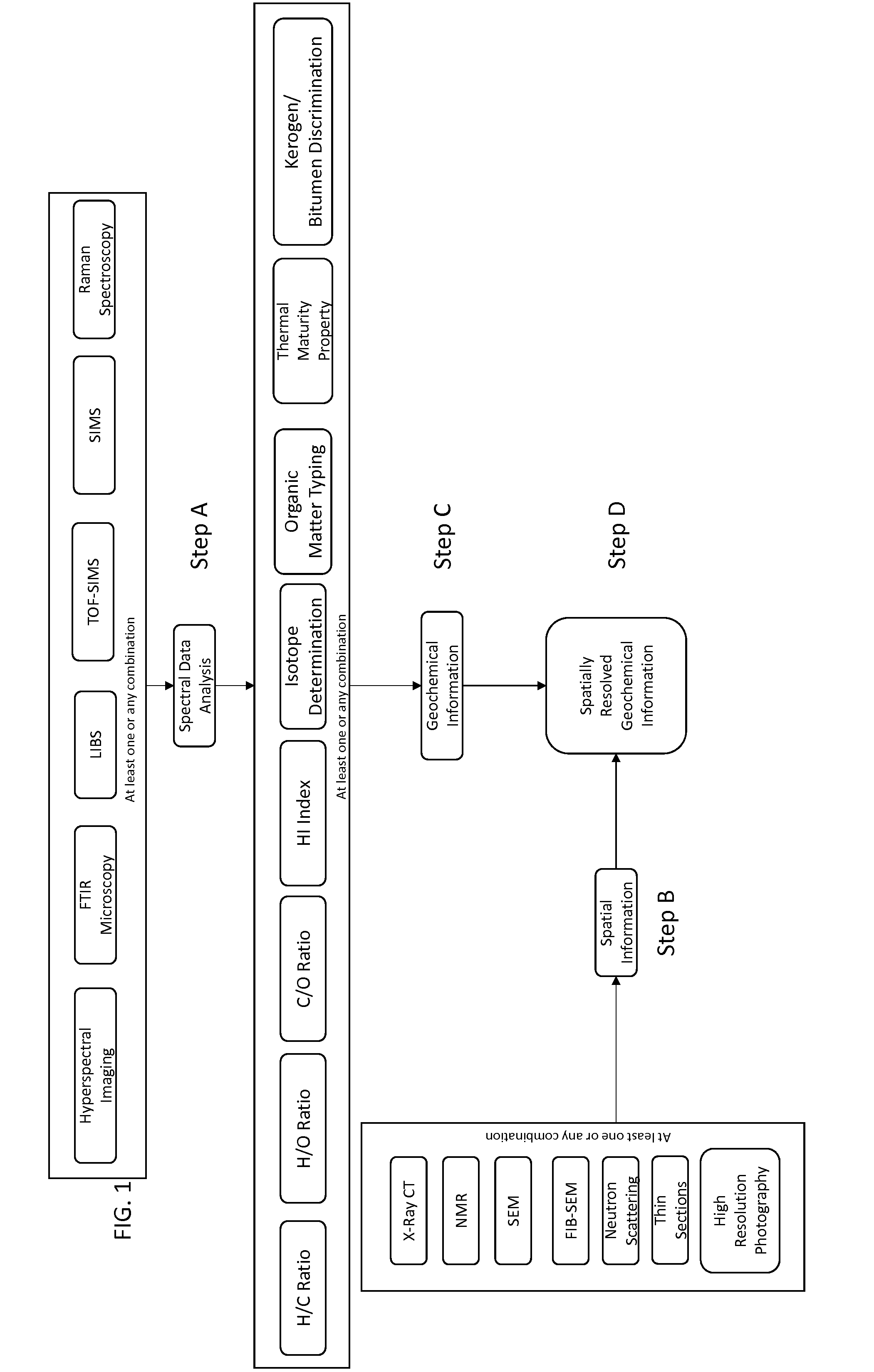
[0018]The present invention relates in part to a method which allows for determining geochemistry with spatial resolution of rocks or other materials. Further, the method can provide a non-bulk method for characterizing the geochemistry of a sample with spatial resolution. The method can be practiced as a rapid, non-destructive geochemical analysis method with respect to a sample. The measurements can be performed on the exact same samples or different samples of similar composition and structure can be used to estimate geochemistry information that does not require preparation. The results of the method of this invention may be used to distinguish kerogen and bitumen in the samples. Rapid thermal maturity estimates can be translated along the length of a core. Spatially resolved maps obtained with the method of the present invention can be applied to sample models to help distinguish between kerogen and bitumen in the models.

[0019]The materials, also referred to herein as the sampl...


PUM


Abstract

A method which allows for determining geochemistry with spatial resolution of geological materials or other materials is provided. The method can provide a non-bulk method of characterizing the geochemistry of a sample with spatial resolution. A system for performing the method also is provided.

Description

[0001]This application claims the benefit under 35 U.S.C. §119(e) of prior U.S. Provisional Patent Application No. 61 / 989,621, filed May 7, 2014, which is incorporated in its entirety by reference herein.FIELD OF THE INVENTION[0002]The present invention relates to spatially resolved geochemical characterisation and, more particularly, to a method for determining geochemistry with spatial resolution, and a system for making such determinations, which can be used for determining geochemistry of geological materials, such as rocks, or other materials.BACKGROUND OF THE INVENTION[0003]Characterisation of source rocks is important for evaluation of both conventional and unconventional reservoirs. Organic matter is deposited and preserved at the bottom of lakes, seas and deltas. As more material is deposited, the organic matter is buried and the heat and pressure of burial transforms the organic matter into geopolymers such as kerogen and bitumen. When the rocks containing organic matter a...

Claims


Application Information

Patent Timeline
IPC IPC(8): G01N33/24G16B45/00
CPCG01N33/241G16C20/20G01V9/007G01V99/005
Inventor WASHBURN, KATHRYN ELIZABETH
Owner HALLIBURTON ENERGY SERVICES INC
Why Eureka
Try Eureka