GNSS receiver with an on-board capability to implement an optimal error correction mode

a technology of error correction mode and receiver, applied in the field of satellite navigation, can solve the problems of inability to achieve better positioning accuracy, inability to achieve accurate positioning, etc., to achieve the effect of improving positioning accuracy, reducing the number of consumer applications, and not being acceptable for professional applications

Active Publication Date: 2016-12-22
CENT NAT DETUD SPATIALES C N E S
View PDF5 Cites 5 Cited by
  • Summary
  • Abstract
  • Description
  • Claims
  • Application Information

AI Technical Summary

Benefits of technology

Thanks to the invention, it is possible for a receiver to select the best operating mode at a moment in time. It is also possible to maintain a local model and a local database of the corrections to be applied and to update this model based on data provided by service providers.
[0030]In some embodiments, the invention allows to select / enrich / blend various local models adapted for specific GNSS constellations, such as the Klobuchar or the NeQuick models, possibly based on an optimization in view of the local conditions of reception of the GNSS signals.

Problems solved by technology

Among the numerous sources of errors to which these calculations may be prone, one of the most important is the ionospheric error, which is due to ionization of the upper layers of the atmosphere which deviates the electromagnetic signals broadcast by the satellites.
Due at least in part to the ionospheric error, a standard single frequency GNSS receiver operating in a standalone non-aided mode will not achieve a positioning precision better than 10 meters, which is not acceptable for professional applications and less and less so even for consumer applications.
However, these receivers are not very efficient in an environment where multipath signals bring significant noise, like the so-called “urban canyons” which include, for example, urban areas with high-rise buildings on multiple sides of a street, or when it is necessary to re-acquire the signals after a loss of sight, like when exiting a tunnel or a parking, or on a cold start.
Currently, this precision is rather limited, and increasing it would be quite costly in terms of infrastructure.
The RTK approach offers a good precision in the vicinity of the reference stations, but this precision degrades rapidly when moving away from a reference station.
But an acceptable precision in a vast area can only be achieved by adding reference stations at a high cost.

Method used


Image

  • GNSS receiver with an on-board capability to implement an optimal error correction mode
  • GNSS receiver with an on-board capability to implement an optimal error correction mode
  • GNSS receiver with an on-board capability to implement an optimal error correction mode

Examples


Embodiment Construction

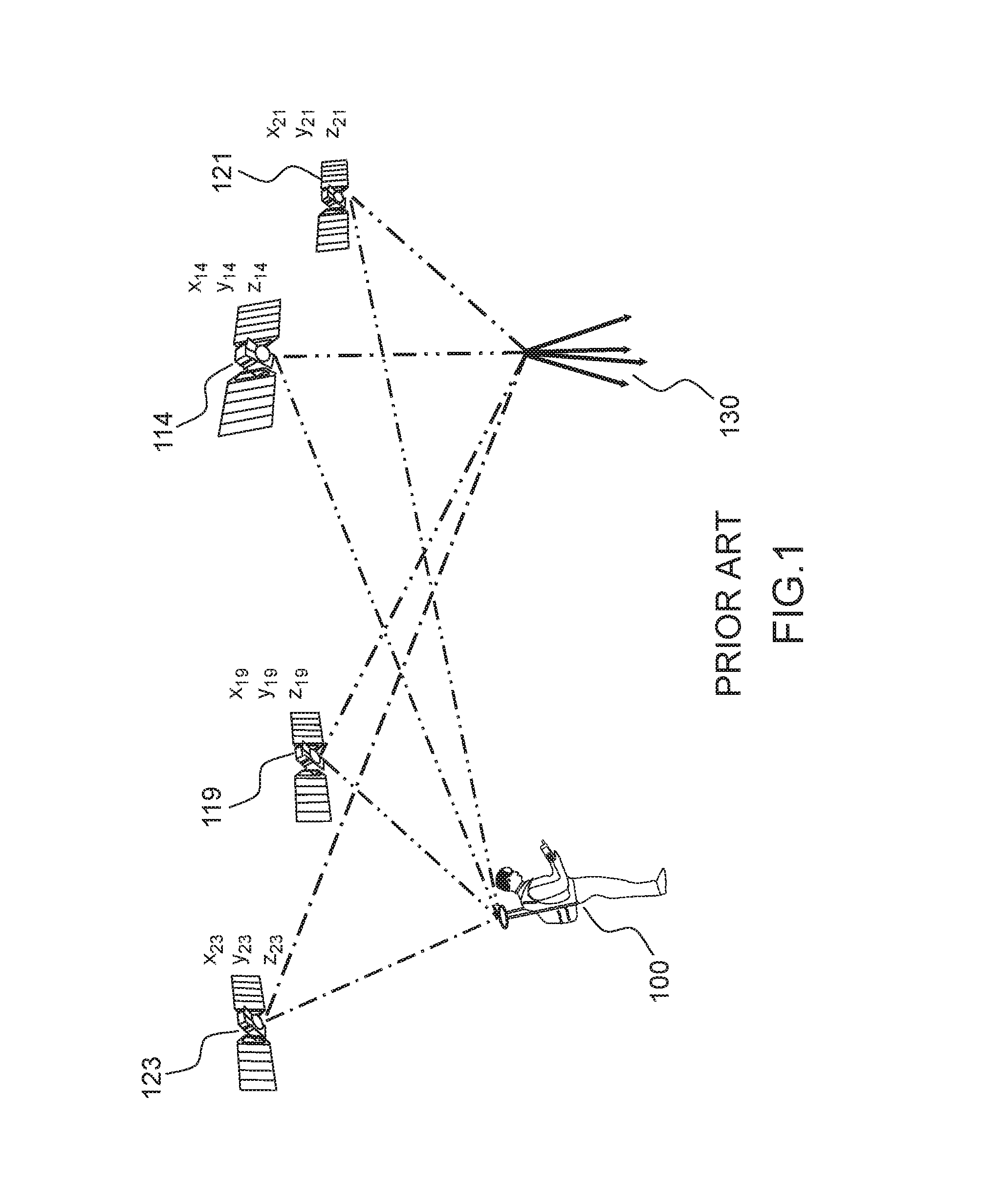
[0040]FIG. 1 represents a differential GNSS system of the prior art.

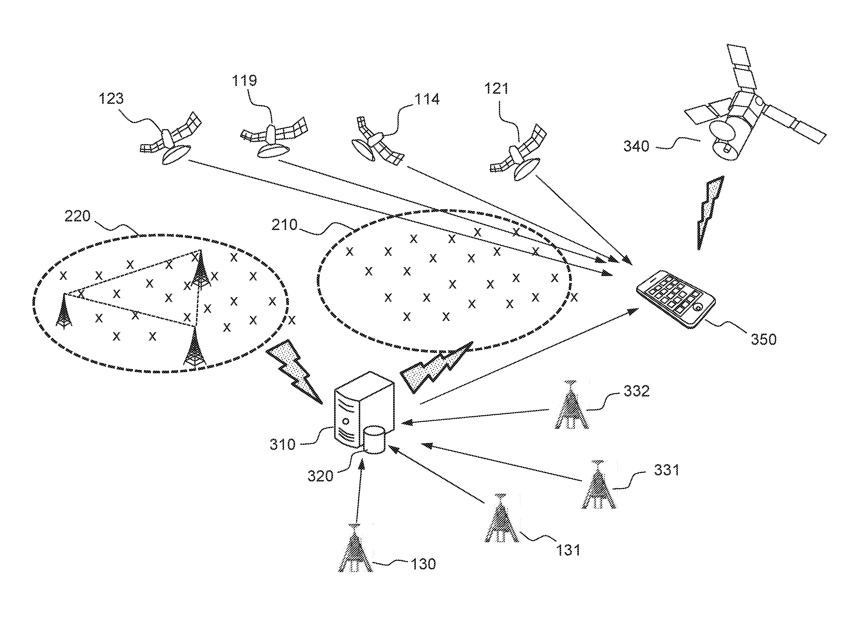
[0041]In a positioning system of a differential type, a user 100 receives positioning signals from at least a satellites constellation, 114, 119, 121, 123. The positioning signals from these satellites are also received by a reference station 130. The user 100 may be moving. The reference station 130 must have a position which is fixed, known with enough precision and located in a radius of 10 to 20 km from the user 100. (see for instance http: / / www.navidedia.net / index.php / RTK_Fundamentals).

[0042]An RTK algorithm can use the code or the phase of the navigation signal, or a combination of both, possibly with a variable weighting. Precision of a position calculation using the phase of the navigation signal is better, because it is less noisy, but the price to be paid is the complexity of solving the integer ambiguity of the measurement.

[0043]An RTK system can not only correct the atmospheric errors (ionosphere, tropos...


PUM


Abstract

The invention discloses a receiver of GNSS positioning signals which has embedded computer logic to select between a first operating mode, which uses all available frequencies, and a second operating mode, which uses only part of the available frequencies but in combination with available correction data. The selection is based on a comparison of an index of quality of reception at the receiver and a computed or predicted precision / confidence level of the corrections. A plurality of corrections types are possible, including a type using a local model and a type using collaborative corrections. In some embodiments, a selection and / or a combination of a plurality of local models may be made to optimize the accuracy of the corrections.

Description

FIELD OF THE INVENTION[0001]The present invention applies to the field of satellite navigation. More specifically the invention allows a satellite navigation receiver to use error and correction models to improve the precision of a calculated position.BACKGROUND[0002]There are two Global Navigation Satellite Systems (GNSS) which have been fully deployed for a number of years (the US Global Positioning System, the Russian GLONASS) and two more which are under deployment (the Chinese Beidou Navigation Satellite System and the European Galileo system). These systems rely on the same principles: microwave radio signals are broadcast from a number of satellites which orbit in a non-geostationary orbit; the signals carry a code which is correlated with a local replica in a receiver configured to receive the broadcast signals; when a receiver is capable of acquiring and tracking signals from a minimum number of satellites (generally four), it is able to calculate its own position, velocity...

Claims


Application Information

Patent Timeline
Patent Type & Authority Applications(United States)
IPC IPC(8): G01S19/07G01S19/25
CPCG01S19/25G01S19/07G16Z99/00G01S19/40G06F16/00G01S19/072G01S19/396G01S19/37G01S19/22G01S19/32G01S19/33G01S19/41G01S19/43G01S19/20G06F9/451G06F3/0484G06F8/38
Inventor ROUGERIE, SEBASTIENROUDIER, MARIONRIES, LIONELLESTARQUIT, LAURENT
Owner CENT NAT DETUD SPATIALES C N E S
Why Eureka
Try Eureka