GNSS-based attitude determination algorithm and triple-antenna GNSS receiver for its implementation

a technology of attitude determination and gnss receiver, applied in surveying and navigation, navigation instruments, instruments, etc., can solve problems such as average measurement errors

Active Publication Date: 2021-06-24
TOPCON POSITIONING SYST INC
View PDF8 Cites 5 Cited by
  • Summary
  • Abstract
  • Description
  • Claims
  • Application Information

AI Technical Summary

Benefits of technology

[0026]Another method of generating phase differences for NLSM is proposed, different from the known GNSS interferometry implementations. Here, a measured full carrier phase difference is presented as a sum of integer carrier cycles and a fractional cycle part. When there is no random noise, the fractional part of the measured full carrier phase difference is equal to the fractional part of the true full carrier phase difference, and the integers of these differences differ in the integer ambiguity. The proposed method utilized only fractional parts of all available full phase differences as measured values in NLSM, and integers are not considered. The proposed algorithm does not take into account integer ambiguity in processing measurements and hence there is no need to provide actual values of the ambiguity. This is an advantage compared to existing methods, because there is no need to constantly control changes in integer ambiguity and to restart the procedure of resolving integer ambiguities when they have been changed.
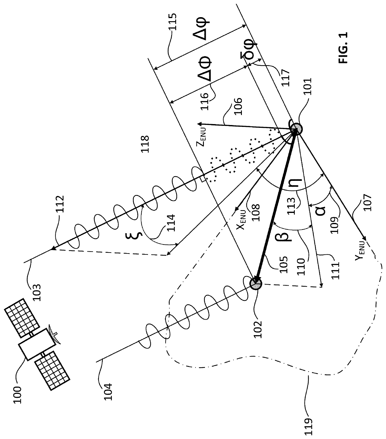
[0030]Each pair of antennas in a tri-antenna configuration can generally receive not matching sets of GNSS signals. In this case angular coordinates of two non-collinear base vectors are determined at the same time, independently and according to different sets of GNSS-measurements. As a result of these measurements, two sets of coordinates for two vectors referenced to the same time moment are obtained. The first set is the coordinates of the base vectors in the vehicle's BF which are highly accurate, do not vary in time, and can be uploaded in the receiver firmware at the step of system installation. The second set is the coordinates of the same vectors relative to ENU which have been obtained in GNSS-measurements and distorted by measuring errors. The attitude problem based on noisy coordinates of some non-collinear vectors is well known in navigation as the Wahba problem [1]. For two vectors this problem is a simple determination of attitude base on two vector measurements obtained from two pairs of GNSS-antennas.
[0038][3] describes a GNSS-based attitude determination system received signals by four antennas at the same time. To process signals, one of the four antennas is selected as a master antenna, all the other antennas are used as slaves. A movable object, whose attitude is determined, is considered flexible, so mutual position of antennas can slightly change. The algorithm calculates a change in mutual position and attitude of the movable objects by co-processing full phase differences between each pair of the master-slave antennas accumulated over some successive epochs. Integer ambiguities are determined for each calculated set of attitude and mutual position parameters for all accumulated carrier (phase) differences. However, this algorithm requires four antennas, rather than three. The proposed algorithm does not use integer ambiguity at the current attitude determination. And, therefore, there is no need to accumulate measurements over some successive epochs, since it determines attitude based on simultaneous measurements obtained for each epoch. Moreover, it does not require to estimate any change in mutual position of slave antennas with respect to the master antenna.
[0041][6] describes a tri-antenna GNSS-system, integrated with an IMU. The three antennas receive GNSS signals at the same time and carrier single and double differences are constructed on their basis. Integer ambiguities are determined in these differences, and relative coordinates of two slave antennas are further calculated by the moving-base RTK method. Object attitude is then determined from these relative coordinates. If the GNSS signals are unavailable, the vehicle's attitude is extrapolated by the IMU data. When the GNSS signal resumes, relative coordinates of the slave antennas are calculated based on the extrapolated attitude. Relative calculated coordinates are used for fast determination of integer ambiguities and repeated start-up of the moving-base RTK algorithm. It should be noted that the proposed invention applies a special version of the GNSS interferometry method without integer ambiguity (the moving base RTK method is used in [6]). Also, the proposed invention uses IMU data for rough initialization of NLSM rather than for calculation of integer ambiguity.
[0042][7] describes an attitude determination system including a dual-antenna GNSS receiver measuring two of three attitude angles of the vehicle's attitude. To obtain a complete orientation, these angles are integrated with IMU data using a Kalman filter. The distance between antennas must not to be longer than three wavelengths of the received signal, or 150 mm. Base vector attitude between two antennas is determined by a standard GNSS interferometry method with integer ambiguity resolution. Calculation of integer ambiguity at the moment of initial or repetitive initialization of the algorithm is performed by the known procedure called the transfer alignment which is used when a vehicle moves at variable speed. The proposed invention uses two base vectors (three antennas), whose angular coordinates are obtained by a special version of the GNSS interferometry method without integer ambiguity. The IMU data in the proposed invention are also used for rough initialization of NLSM, rather than for transfer alignment procedure. It allows quick re-initialization of the proposed algorithm even in case of an unmoving vehicle.

Problems solved by technology

This base vector averages measuring errors during processing redundant measurements.

Method used


Image

  • GNSS-based attitude determination algorithm and triple-antenna GNSS receiver for its implementation
  • GNSS-based attitude determination algorithm and triple-antenna GNSS receiver for its implementation
  • GNSS-based attitude determination algorithm and triple-antenna GNSS receiver for its implementation

Examples


Embodiment Construction

[0062]Reference will now be made in detail to the embodiments of the present invention, examples of which are illustrated in the accompanying drawings.

[0063]FIG. 1 shows a structure of the first difference of the true values of the full phases of the carrier frequency measured by one pair 118 of master antenna 101 and slave antennas 102. The navigation satellite 100 transmits the navigation signal, which is simultaneously received by the master antenna 101 and the slave antenna 102. The GNSS satellites may be any of, e.g., GPS, Galileo, ZQZZ, GLONASS or BEIDOU, and can transmit on any of the bands[0064]GPS L1, L2, L5;[0065]Galileo L1, L2, E5a, E5b;[0066]QZSS L1, L2, L5, E6;[0067]GLONASS L1, L2, L3;[0068]BEIDOU B1, B2, B3.

[0069]Because the navigation satellite 100 is placed very far from both receiving antennas, signal propagation paths may be considered as two parallel rays 103 (received by the master antenna 101) and 104 (received by the slave antenna 102). The origin of the base v...


PUM


Abstract

An algorithm for determining of a vehicle orientation based on a coherent processing of GNSS signals received by three spaced antennas and a special GNSS receiver for implementing this algorithm are considered. The three antennas are logically combined into two pairs, with one of the antennas becoming common for both pairs. The GNSS receiver measures the first carrier phase difference between the signals received within each pair of antennas. The first differences of the full phases are represented as the sum of an integer number of periods of the carrier frequency and the fractional part of the period. Values of the fractional parts of the first differences are used to compute the orientation of the vector connecting the antennas phase centers within each pair. The use of the fractional parts of the first differences makes it possible to exclude the integer ambiguity resolution in carrier phase measurements. The attitude of the vehicle is calculated from the orientation of two non-collinear vectors with a common origin, measured by two pairs of antennas. In the special GNSS receiver for the vehicle's attitude measurements, each antenna is connected to its own RF front end. All RF front ends, heterodynes, digital navigation processors of this receiver are clocked from one common clock oscillator. In this case, all the carrier phase measurements of the GNSS signals received by the three spaced antennas are performed and processed coherently, i.e. in a common time scale.

Description

BACKGROUND OF THE INVENTIONField of the Invention[0001]The present invention relates to the field of developing attitude determination algorithms based on GNSS (Global Navigation Satellite System) signals and building attitude determining GNSS receivers.Background of the Related Art[0002]GNSS positioning uses a geocentric coordinate system—Earth Centered Earth Fixed (ECEF)—rigidly related to the rotating Earth. Coordinates of a point relative to ECEF are called “absolute coordinates”. It is well known from theoretical mechanics that absolute coordinates of three points, which are rigidly connected to a solid body and not lying on the same line, can fully describe the position and attitude of the body in ECEF. The three points can be logically combined into two pairs, one the points being common for both pairs. A vector can be drawn between each pair of the points, such that its origin would be at the common point. As a result, there are two vectors originating from the same point an...

Claims


Application Information

Patent Timeline
Patent Type & Authority Applications(United States)
IPC IPC(8): G01S19/54G01C21/16G01S19/47
CPCG01S19/54G01S19/47G01C21/165
Inventor VASILYUK, NIKOLAY NIKOLAEVICHVOROBIEV, MIKHAIL YURIEVICHTOKAREV, DMITRY KONSTANTINOVICHDORONIN, ALEXANDR VLADIMIROVICHTYCHINSKIY, SERGEY IVANOVICH
Owner TOPCON POSITIONING SYST INC
Why Eureka
Try Eureka