System and method for in-flight trajectory path synthesis using the time sampled output of onboard sensors

a sensor and trajectory technology, applied in the field of sensor systems, can solve the problems of difficult to obtain highly accurate range or altitude predictions using only a single fuze sensor, easy jamming, and high range error of airburst lethality for targets under direct fire, so as to reduce the computational/information transfer burden placed on the fire control computer, the effect of superior sensor fusion capability and reduced data

Inactive Publication Date: 2007-07-31
UNITED STATES OF AMERICA THE AS REPRESENTED BY THE SEC OF THE ARMY
View PDF26 Cites 64 Cited by
  • Summary
  • Abstract
  • Description
  • Claims
  • Application Information

AI Technical Summary

Benefits of technology

[0026]Generally, the invention is a method for the in-flight fusion of time-sampled outputs from an arbitrary suite of onboard sensors into a collective prediction of projectile position as a function of time-from-launch. The performance of this sensor fusion capability is superior, in terms of accuracy and robustness, to that arising from any one particular individual sensor within the onboard suite. The method itself is independent of the number of, or nature of, the sensors in the suite. In particular, the invention makes only the minimal assumption that the ultimate (possibly signal-processed) output of each sensor comprises a time-labeled, finite sequence of real numbers for a pre-determined set of unique time sample values. One of the many applications of the invention is the fusion of a suite of onboard fuze sensors into an accurate range-sensing fuze, an accurate altitude-sensing fuze, or both. Moreover, the invention provides for the reduction in the amount of data transferred to the ground by the fire control computer for each occasion, and / or for using pre-computed, stored results to reduce / eliminate the computational / information-transfer burden placed upon the fire control computer. Obviously, this could be useful for future systems, as well as for retrofits to existing / older systems, which were not originally designed with the invention in mind.
[0027]The invention indicates that combining the output of several independent fuze sensors lead to both improved accuracy and greater robustness, thus overcoming limitations of conventional fuze-sensing methods. Numerous Monte Carlo simulations testing the validity of the invention indicate that the invention can both make use of, and improve upon, current timer and GMR (giant magnetoresistance) magnetometer sensor technology. As MEMS (micro electromechanical systems) accelerometer and other sensor technologies mature for gun rugged use, they can easily be added to existing onboard sensor suites. As such, the invention can then be used to combine the sensors' time-series outputs into a single, collective time-to-detonate decision that is even more robust and accurate than before.
[0028]In addition to these small / medium caliber benefits, the invention provides potentially cheaper, more compact, non-jammable, low power alternatives to existing fuze sensors even for large caliber munitions. For example, a GPS based fuzing system, which can be jammed, may be replaced by a collection of cheaper, non-jammable sensors (timing, turns counting, etc.) whose collective fuzing performance is made comparable to that of GPS by application of the invented method. Similarly, the conventional HOB (height above ground) proximity sensor, which is jammable and also susceptible to premature detonation due to tree clutter, may also be replaced by a collection of cheaper, smaller, non-jammable sensors, which are accurate even for ground targets within dense forests. Moreover, the invention accounts for and corrects multiple error sources simultaneously. Additionally, the invention provides an accurate longer range (1500 m and beyond) range-sensing and / or altitude-sensing fuze which also satisfies the practical constraints associated with small / medium caliber, air bursting munitions.

Problems solved by technology

The breadth of non-trivial range-error sources and altitude-error sources makes it difficult, however, to obtain highly accurate range or altitude predictions using only a single fuze sensor, such as a timer or an ambient electric / magnetic field sensor to count turns of the spin-stabilized projectile.
The in-flight prediction of all or part of this information, or information derived thereof, is a problem of paramount importance for military applications.
Airburst lethality for targets under direct fire is much more sensitive to range error than it is to either altitude or deflection error.
However, these sensors do have their disadvantages as well including that the dependence of these sensors upon external signals means that they are susceptible to jamming, hence a backup fuze-sensing system is advisable.
Also, clutter (such as tree canopies) can reduce the reliability of proximity sensors or hinder projectile tracking.
In addition, small volume, shape-conformity, low unit cost, gun ruggedness (high acceleration tolerance), and low power consumption constraints on the onboard sensors and their associated electronics severely limit the options available for in-flight trajectory sensing, and hence range-sensing in particular.
These constraints tend to preclude the use of sensors from this first class in many small / medium caliber munitions.
However, three of the biggest causes of differences between trajectory predictions for a given model and actual test flight trajectories arise from (1) the lack of accurate, flight-test-corrected aerodynamic data in the model; (2) inaccuracy / uncertainty of Met / initial-condition data in the model; and (3) the limitations of the model itself.
Unfortunately, the actual trajectory taken by the projectile differs from the computed nominal trajectory mainly due to differences between the measured projectile flight and the actual projectile flight.
However, a problem that may occur with conventional approaches is that the nominal trajectory, upon which they depend, may be significantly in error due to the accumulated effect of numerous error sources.
Unfortunately, there is usually no single sensor, which can directly measure the value of θlethal.
As previously indicated, the problem with this standard practice is that when the above condition is actually attained one usually has a significant, nonzero error:
Ultimately, there are two main issues pertaining to range sensing accuracy that are not addressed by any of these methods individually.
First, not only are there many error sources leading to a significant cumulative range error, but a significant number of them are each individually significant contributors to range error.
Second, sensing a gauge variable merely to detect a target value is a waste of valuable information, and using onboard resources merely as a sentinel is a waste of computing potential.
This potential has largely been unexploited in conventional range sensing strategies.

Method used


Image

  • System and method for in-flight trajectory path synthesis using the time sampled output of onboard sensors
  • System and method for in-flight trajectory path synthesis using the time sampled output of onboard sensors
  • System and method for in-flight trajectory path synthesis using the time sampled output of onboard sensors

Examples


Embodiment Construction

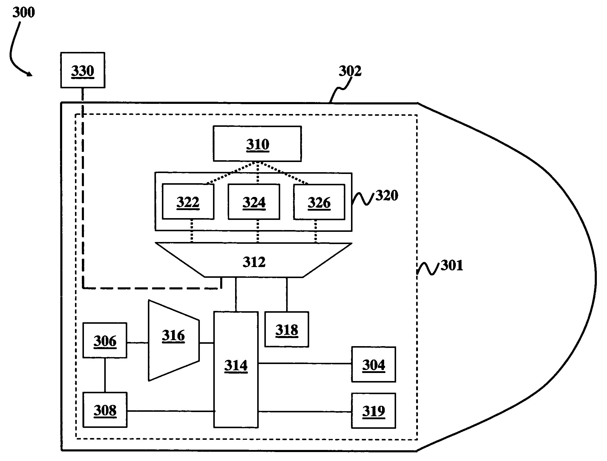
[0043]The invention and the various features and advantageous details thereof are explained more fully with reference to the non-limiting embodiments that are illustrated in the accompanying drawings and detailed in the following description. It should be noted that the features illustrated in the drawings are not necessarily drawn to scale. Descriptions of well-known components and processing techniques are omitted so as to not unnecessarily obscure the invention. The examples used herein are intended merely to facilitate an understanding of ways in which the invention may be practiced and to further enable those of skill in the art to practice the invention. Accordingly, the examples should not be construed as limiting the scope of the invention. Referring now to the drawings, and more particularly to FIGS. 1 through 10, there are shown preferred embodiments of the invention.

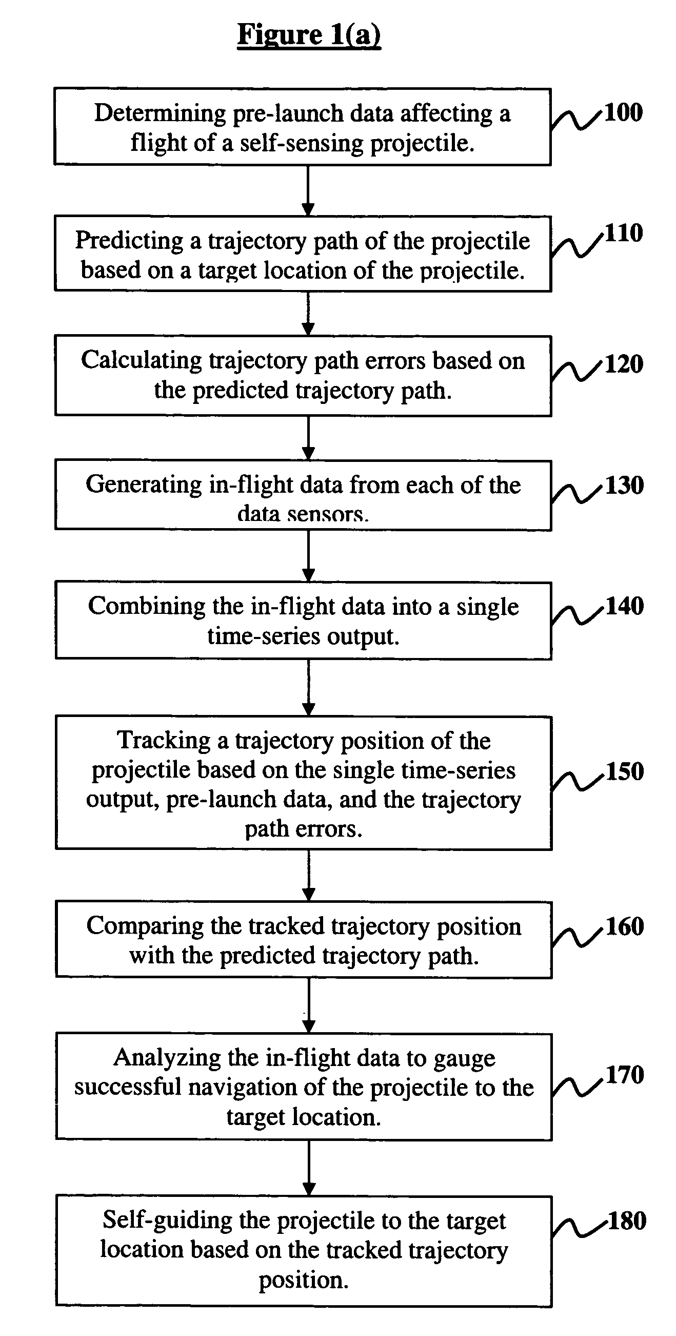
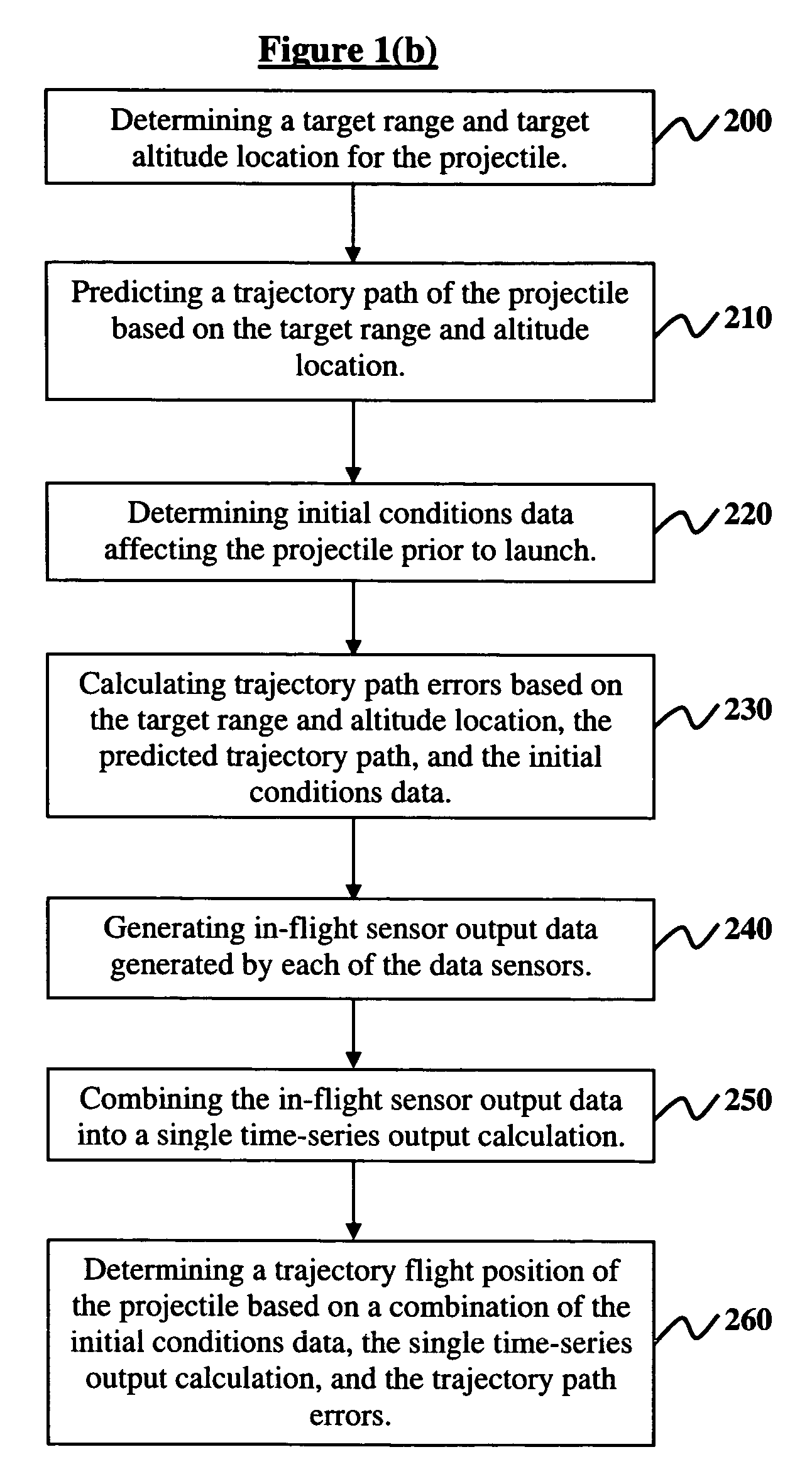
[0044]FIG. 1(a) illustrates a flow diagram for a method of data fusion, wherein the method comprises determ...


PUM


Abstract

Disclosed are a system, method, and program storage device implementing the method, of data fusion, wherein the method comprises determining pre-launch data affecting a flight of a self-sensing air-bursting ballistic projectile, the projectile comprising a plurality of independent data sensors; predicting a trajectory path of the projectile based on a target location of the projectile; calculating trajectory path errors based on the predicted trajectory path; generating in-flight data from each of the data sensors; combining the in-flight data into a single time-series output using a fusion filter; tracking a trajectory position of the projectile based on the single time-series output, pre-launch data, and the trajectory path errors; comparing the tracked trajectory path with the predicted trajectory path; analyzing the in-flight data to gauge successful navigation of the projectile to the target location; and self-guiding the projectile to the target location based on the trajectory position.

Description

GOVERNMENT INTEREST[0001]The invention described herein may be manufactured, used, and / or licensed by or for the United States Government.BACKGROUND OF THE INVENTION[0002]1. Field of the Invention[0003]The invention generally relates to sensor systems, and more particularly to systems and methods of attaining data fusion from sensor suites onboard ballistic projectiles.[0004]2. Description of the Related Art[0005]Within this application several publications are referenced by Arabic numerals within brackets. Full citations for these and other publications may be found at the end of the specification immediately preceding the claims. The disclosures of all these publications in their entireties are hereby expressly incorporated by reference into the present application for the purposes of indicating the background of the invention and illustrating the general state of the art.[0006]For application to small / medium caliber, air bursting munitions, for which neither Global Positioning Sy...

Claims


Application Information

Patent Timeline
Patent Type & Authority Patents(United States)
IPC IPC(8): F41G7/00F42B15/01G01S13/00
CPCF41G7/346F41G7/36F42B15/01
Inventor FLIPPEN, JR., LUTHER D.
Owner UNITED STATES OF AMERICA THE AS REPRESENTED BY THE SEC OF THE ARMY
Why Eureka
Try Eureka