Data blending method of navigation system combined by SINS/GPS micromagnetic compass

An integrated navigation system and data fusion technology, applied in the field of data fusion of SINS/GPS/magnetic compass integrated navigation system, can solve problems such as complex calculation, difficult to meet spacecraft navigation requirements, and influence on magnetic compass

Inactive Publication Date: 2007-07-18
BEIHANG UNIV
View PDF0 Cites 77 Cited by
  • Summary
  • Abstract
  • Description
  • Claims
  • Application Information

AI Technical Summary

Problems solved by technology

At present, there are two commonly used methods for data fusion of SINS/GPS/magnetic compass integrated navigation system, one is to directly use the magnetic field strength error (obtained by comparing the measured value of the magnetic compass with the known vector value in the reference system) as the quantity Combining measured information with SINS and GPS, this method improves the accuracy of the heading angle of the system (it is often used in the aerospace field); but this combined estimation method must be based on the premise of knowing the trajectory information and the geomagnetic field model at that time. more complex
The other is to use the heading angle error (the difference between the heading angle calculated by the magnetic compass and the heading angle obtained by SINS) as the measurement information to combine with SINS and GPS to suppress the divergence of the heading angle error of the system. Many); but the heading angle must be obtaine

Method used


Image

  • Data blending method of navigation system combined by SINS/GPS micromagnetic compass
  • Data blending method of navigation system combined by SINS/GPS micromagnetic compass
  • Data blending method of navigation system combined by SINS/GPS micromagnetic compass

Examples


Embodiment Construction

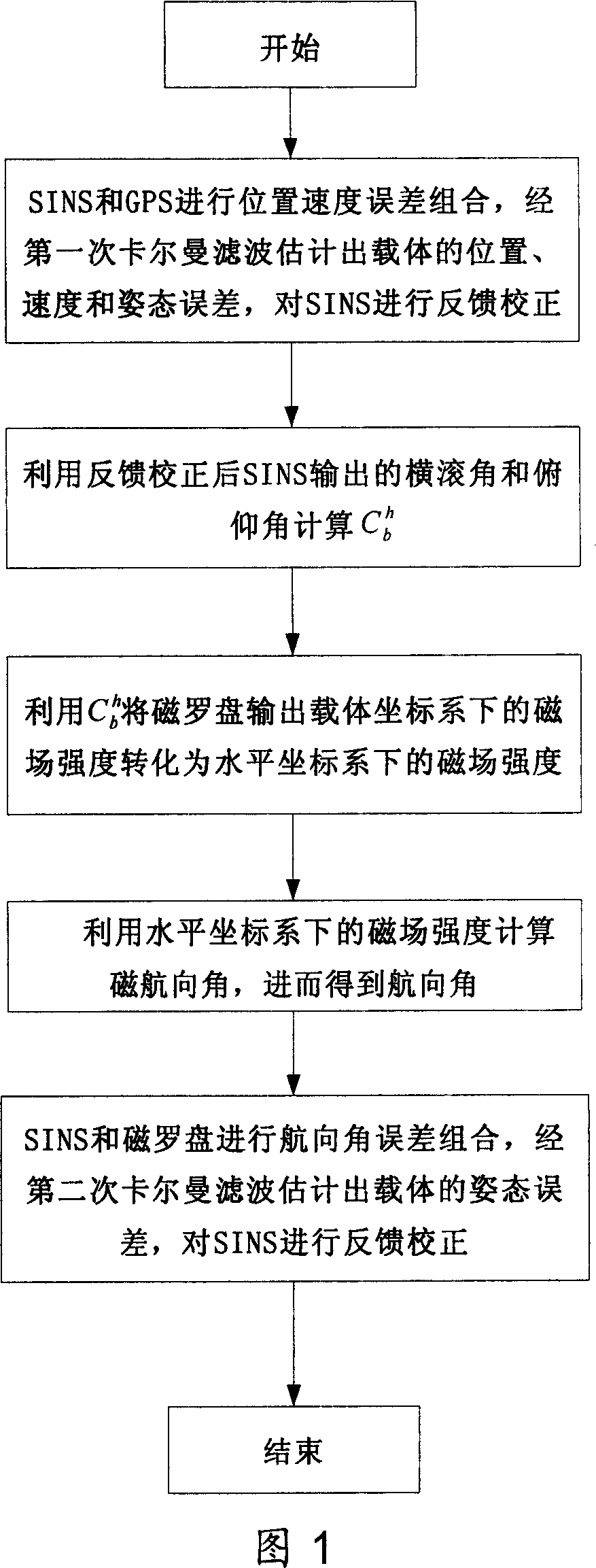
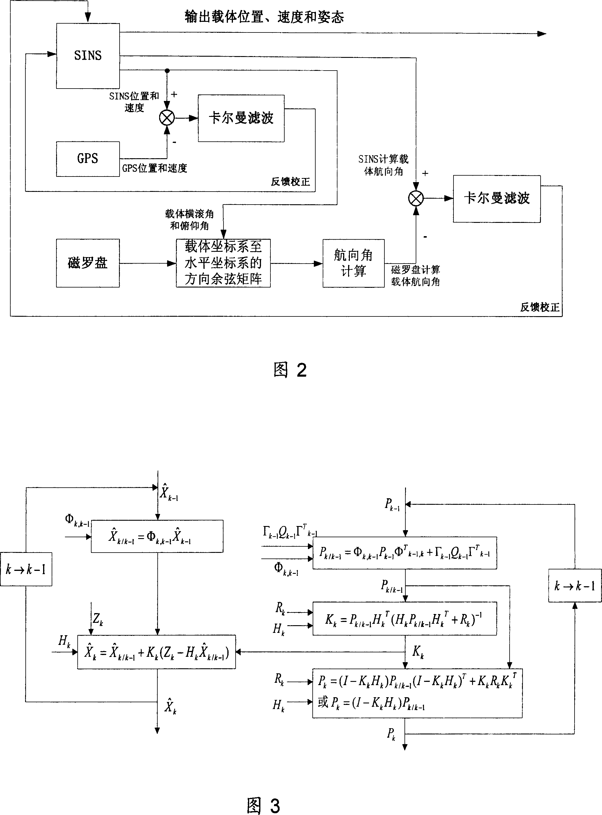
[0032] As shown in Fig. 1,2,3, concrete method of the present invention is as follows:

[0033] (1) Combine the position and velocity errors of SINS and GPS to obtain the error equation, estimate the position, velocity and attitude errors of the carrier through the first Kalman filter, and perform feedback correction on the position, velocity, roll angle and pitch angle of SINS ;

[0034] ① The error equations for combining position and velocity errors between SINS and GPS include system state equations and measurement equations, as shown in formula (1) and formula (2) respectively.

[0035] System state equation:

[0036]

[0037] Among them, X 1 =[φ E φ N δV E δV N δV U δL δλ δh ε E ε N _ U ] is the system state vector, W 1 =[w εE w εN w εU w _E w _N w _U ] T is the system noise vector, F 1 is the system transition matrix, G 1 is the noise transformation matrix. φ E and φ N is the east and north platform misalignment angle; δV E , δV N...


PUM


Abstract

The invention relates to SINS/GPS magnetic compass integrated navigation system data fusion method. It includes the following steps: processing position speed error combination for the SINS and GPS; estimating carrier position, speed, and altitude error by the first Kalman filtering to feed back and rectify SINS; calculating direction cosine matrix from carrier coordinate system to level coordinate system by outputted roll angle and pitch angle to assist magnetic compass to gain carrier magnetic course angle, and course angle; processing course angle error combination for the SINS and magnetic compass; estimating carrier altitude error by the second Kalman filtering to feed back and rectify SINS; outputting carrier position, speed, and altitude information from SINS to user. The invention has the advantages of simple computing, high precision, strong fault tolerant ability and wide application. Thus it can be used to increase magnetic compass altitude fixing precision, navigation precision of the SINS/GPS magnetic compass integrated navigation system used in space craft, aircraft, shipping, or surface car.

Description

technical field [0001] The invention relates to a data fusion method of a SINS / GPS / magnetic compass integrated navigation system. The method has the advantages of simple calculation, high precision, strong fault tolerance and wide application fields, and can be used to improve the performance of aircraft, spacecraft, ships or ground Navigation accuracy of SINS / GPS / magnetic compass integrated navigation system for vehicles. Background technique [0002] Strapdown Inertial Navigation System (SINS) is a completely autonomous navigation system that can continuously and real-time provide position, velocity and attitude (roll angle, pitch angle and heading angle) information, and its short-term accuracy It is very high, and has the advantages of good concealment and not limited by climatic conditions, so it is widely used in aviation, aerospace, navigation and other fields. However, the SINS error increases with time, so it is often combined with the Global Positioning System (GP...

Claims


Application Information

Patent Timeline
IPC IPC(8): G01C21/00G01C21/26G01C21/28G01C21/24G01C21/16G01C21/04G01C21/08G01C21/20G01S1/02G01S5/02G01S19/40
Inventor 房建成曹娟娟盛蔚刘百奇张海鹏李建利
Owner BEIHANG UNIV
Why Eureka
Try Eureka