
Digital visual method for rapidly measuring cover degree of grass and forest vegetation

A rapid measurement, digital technology, applied in the field of digital fine grass and forestry, can solve the problems of long cycle, heavy workload, and inability to accurately quantitatively measure

Inactive Publication Date: 2009-05-06
NANJING UNIV
View PDF0 Cites 17 Cited by
  • Summary
  • Abstract
  • Description
  • Claims
  • Application Information

AI Technical Summary

Problems solved by technology

[0005] Conventional manual methods for estimating grassland cover are not only cumbersome, long-term, expensive, and heavy workload, but also cannot be accurately quantitatively measured.

Method used


Image

  • Digital visual method for rapidly measuring cover degree of grass and forest vegetation
  • Digital visual method for rapidly measuring cover degree of grass and forest vegetation
  • Digital visual method for rapidly measuring cover degree of grass and forest vegetation

Examples


Embodiment 1

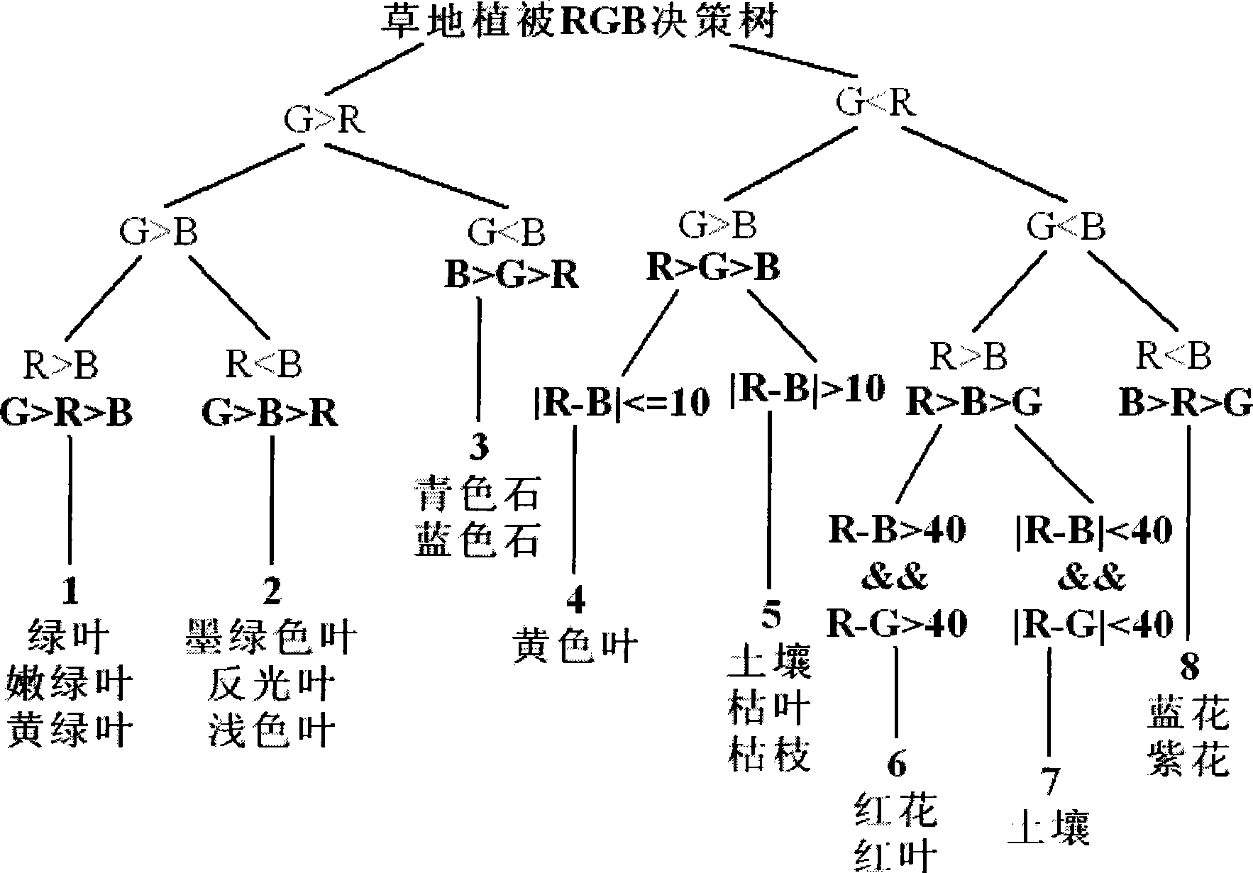
[0079] Taking Fukang grassland in Xinjiang as an example, we selected 14 grasslands with high, medium and low coverage according to the grassland vegetation coverage, and the quadrat size is 1×1m 2 , using the acupuncture method to obtain grassland vegetation coverage, and at the same time take pictures directly above the sample quadrat. We choose 100 pricking points for high-coverage grassland, 200 pricking points for medium-coverage grassland, and 500 pricking points for low-coverage grassland. Each coverage type grassland quadrat was measured three times and the average value was taken as the vegetation coverage of the quadrat. Simultaneously, utilize the present invention to calculate high, middle and low three kinds of grassland cover of cover respectively as table 1 and Figure 6 shown.

[0080] From Table 1 and Figure 6 It can be seen that there is little deviation between the vegetation cover measured by the acupuncture method and the cover obtained by the present ...

Embodiment 2

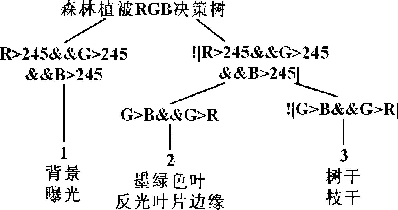
[0085] Under normal light conditions, there are obvious differences in the brightness and color of the branches and leaves of the arbor layer in the forest community and the sky background. We selected a representative forest canopy in the Zijin Mountain forest community sample plot in Nanjing, and used a digital camera to shoot vertically upwards to obtain photos of forest canopy density. The photos taken were sent to 5 experts with practical experience for visual inspection, and the average value was taken as the visual forest coverage. Then utilize the coverage value that the inventive method obtains to carry out comparative analysis as table 2 and Figure 7 shown.

[0086] From Table 2 and Figure 7 It can be seen that the coverage value obtained by the calculation method of vegetation coverage has little difference, and the maximum error is 4.8%, which shows that this method has high accuracy in calculating forest coverage.

[0087] Table 2. Experts' visual forest cove...


PUM

PropertyMeasurementUnit
Heightaaaaaaaaaa

Abstract

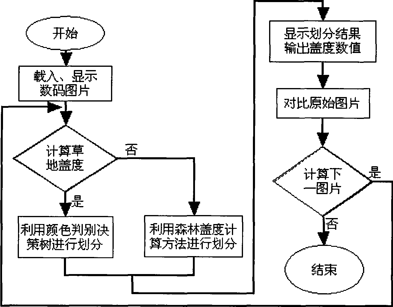
The invention belongs to the technical field of digitized fine grass cultivation and forest industry by combining vegetational community coverage calculation method and digital imaging as well as computer technology, which is suitable for the grassland vegetation having the height being less than 1 m and the coverage within the range of 5-99 percent; the height of forest cover is more than 5 m, and the shade density is more than 0.5; by combining the advanced digital imaging and computer image processing technology, a color distinguishing decision tree with three primary colors which are red, green and blue is constructed by utilizing the classification means of the decision tree from top to bottom, and taking digital photo software shot in the field as input item according to the color attribute difference of the grass and forest vegetations, and functional modules of digital photo software leading-in, ground object distinguishing, coverage calculating, divided result displaying and contrasting and the like are integrated on a Matlab7.0 platform to set up a visual interface and visual figures which are user interface friendly as well as convenient and fast in human-computer interaction, then the numerical value is calculated. The method can treat the conventional picture formats such as jpg, tif, tiff and bmp in batch to obtain the coverage data of grass and forest vegetations and has the observation accuracy reaching over 95 percent, and can be applied to the related fields such as vegetation dynamic monitoring, resources surveys, global changing vegetation monitoring, etc.

Description

1. Technical field [0001] The invention belongs to the technical field of digitized fine grass industry and forestry combining a calculation method of vegetation community coverage with digital imaging and computer technology; in particular, it relates to a digital visualization method for quickly measuring grass and forest vegetation community coverage. It is suitable for the measurement of vegetation coverage in the range where the shooting angle of the digital camera is perpendicular to the horizon, the height of grassland vegetation is less than 1m, and the coverage is 5%-99%; the height of forest vegetation is greater than 5m, and the canopy density is above 0.5. The invention is also applicable to other related fields such as dynamic monitoring of vegetation, resource investigation, remote sensing monitoring of global change vegetation and the like. 2. Background technology [0002] Vegetation is an important natural resource and the main component of terrestrial ecosy...

Claims


Application Information

Patent Timeline
IPC IPC(8): G01B11/28G01C11/04G06T1/00G06V10/56
CPCG06K9/4652G06K9/00657G06V20/188G06V10/56
Inventor 李建龙钱育蓉杨峰杨齐干晓宇
Owner NANJING UNIV
Learn More