Map feedback correction method of inertial navigation system

A technology of inertial navigation system and correction method, which is applied in the field of inertial navigation system map feedback correction, can solve the problems of loss of navigation, poorer positioning accuracy, and inertial navigation system can not be compared, etc., to achieve the goal of increasing credibility Effect

Inactive Publication Date: 2009-11-25
UNIVERSAL SCIENTIFIC INDUSTRIAL (SHANGHAI) CO LTD
View PDF1 Cites 37 Cited by
  • Summary
  • Abstract
  • Description
  • Claims
  • Application Information

AI Technical Summary

Problems solved by technology

[0007] 1. The satellite navigation system is easily affected by the terrain. Once the satellite signal is blocked by the terrain, the satellite navigation system cannot provide the positioning function and lose the navigation function
[0008] 2. Although the inertial positioning system will not be affected by the terrain and fail, but the inertial positioning system will generate cumulative errors, making the positioning accuracy worse and farther away, so it must be corrected frequently
[0010] However, the above-mentioned patents have the following disadvantages: Although the problem of cumulative error is solved, once the GPS signal cannot be received for a long time, the inertial navigation system will not be able to compare and determine the corrected error

Method used


Image

  • Map feedback correction method of inertial navigation system
  • Map feedback correction method of inertial navigation system
  • Map feedback correction method of inertial navigation system

Examples


Embodiment Construction

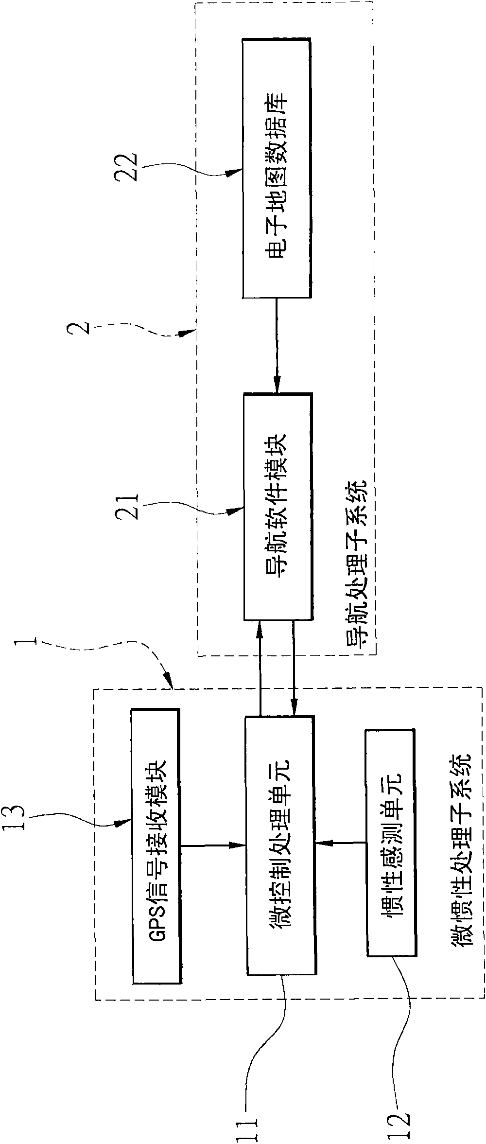
[0044] see figure 2 as shown, figure 2 Shows the system structure of the inertial navigation system map feedback correction method of the present invention, and the system structure includes: a micro-inertial processing subsystem 1 and a navigation processing subsystem 2, the micro-inertial processing subsystem 1 and the navigation processing sub-system The systems 2 are electrically connected to each other. In addition, the micro-inertial processing subsystem 1 and the navigation processing subsystem 2 can also transmit and receive information through radio connection, that is, the micro-inertial processing subsystem 1 and the navigation processing subsystem 2 are each provided with a transmitting unit and a receiving unit (not shown in the figure).

[0045] The micro-inertial processing subsystem 1 has a micro-control processing unit 11 (MCU), an inertial sensing unit 12 and a GPS signal receiving module 13, wherein the micro-control processing unit 11 is electrically co...


PUM


Abstract

The invention discloses a map feedback correction method of an inertial navigation system. A micro-control processing unit, an inertial sensing unit, a GPS signal-receiving module, a navigation software module and an electronic map database are matched to establish path-planning point information; measuring information is provided by the inertial sensing unit to the micro-control processing unit for processing so as to generate inertial navigation path point information when no GPS signal is received; correction value information is generated by comparing the prior latitude and longitude information on the path-planning point information and the inertial navigation path point information; and then, accumulated errors generated by the inertial sensing unit is corrected by the correction value information to improve the positioning precision. The map feedback correction method of the inertial navigation system corrects the accumulated errors of the inertial navigation system by the latitude and longitude information provided by the electronic map database.

Description

technical field [0001] The invention relates to a feedback correction method, in particular to a map feedback correction method of an inertial navigation system which uses map longitude and latitude information to integrate and process data provided by an inertial navigation system for error correction. Background technique [0002] The satellite navigation system is one of the positioning systems frequently used by vehicles at present, such as figure 1 As shown, the known satellite navigation system includes an input device 1a, a GPS receiving device 2a, a planar electronic map database 3a, a route selection device 4a, a navigation software device 5a, a communication device 6a and a display device 7a. [0003] The input device 1a is used to provide function selection, and the GPS receiving device 2a is used to receive satellite signals to locate the current position of the car, and provide this relevant information to the navigation software device 5a and the route selectio...

Claims


Application Information

Patent Timeline
Patent Type & Authority Applications(China)
IPC IPC(8): G01C21/26G01C21/34G01C21/16G01C21/18
Inventor 李春煌
Owner UNIVERSAL SCIENTIFIC INDUSTRIAL (SHANGHAI) CO LTD
Why Eureka
Try Eureka