Self-adaptive multilevel cache system for three-dimensional spatial data based on data content

A technology of three-dimensional space and caching system, which is applied in the field of geospatial information system, can solve problems such as difficult to take into account the integrated processing of three-dimensional space data, and achieve the effects of solving large delays in access requests, improving scheduling efficiency, and improving processing capabilities

Inactive Publication Date: 2010-04-07
WUHAN UNIV
View PDF0 Cites 64 Cited by
  • Summary
  • Abstract
  • Description
  • Claims
  • Application Information

AI Technical Summary

Problems solved by technology

Digital earth systems such as Google Earth and Virtual Earth 3D establish disk file caches on the client side to reduce the number of server visits and improve the efficiency of data scheduling. However, these s

Method used


Image

  • Self-adaptive multilevel cache system for three-dimensional spatial data based on data content
  • Self-adaptive multilevel cache system for three-dimensional spatial data based on data content
  • Self-adaptive multilevel cache system for three-dimensional spatial data based on data content

Examples


Example Embodiment

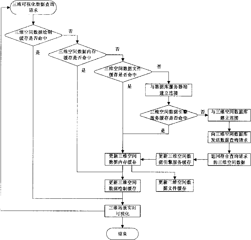
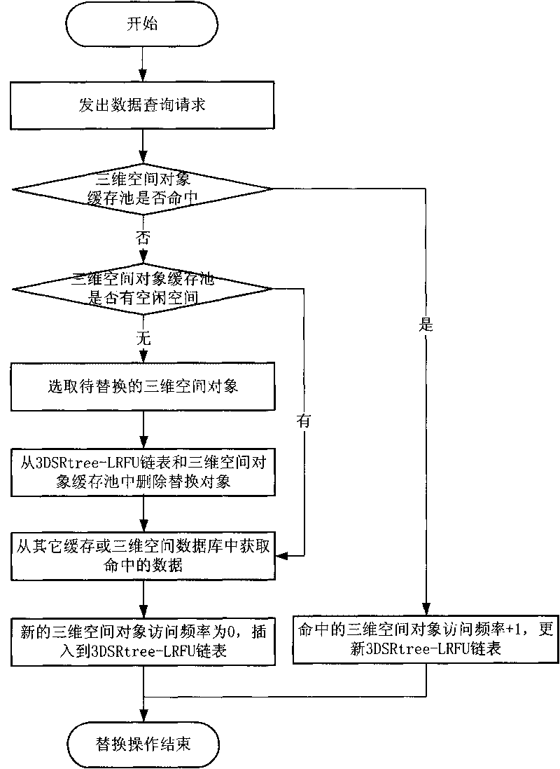
[0058] The technical scheme of the present invention is described in detail below in conjunction with accompanying drawing:

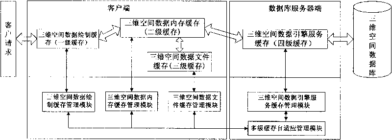
[0059] The existing spatial database system includes a client and a database server, and the client and the database server establish a communication connection, usually through a high-speed local area network. Since the database server uses database technology to store massive 3D spatial data, when the user watches a 3D scene through the client, the database server provides the corresponding 3D spatial data to the client. Therefore, the server side of the database is generally realized by using the server to provide a three-dimensional spatial database, and the client side is realized by a PC. The present invention designs four-level cache and corresponding cache management modules at all levels in the system. The so-called four-level cache is the three-dimensional space data rendering cache (level one cache), three-dimensional space data memory cache ...


PUM


Abstract

The invention relates to a self-adaptive multilevel cache system for three-dimensional spatial data based on a data content, the multilevel cache for the three-dimensional spatial data of the system adopts the design idea of a buffer pool, and the three-dimensional spatial data is classified and managed in separate pools when in cache by a three-dimensional spatial data classification method based on the data content; wherein the cache comprises a three-dimensional spatial data drawing cache (first-level cache) located at a client, a three-dimensional spatial data memory cache (second-level cache), a three-dimensional spatial data file cache (third-level cache) and a three-dimensional spatial data engine service cache (fourth-level cache) located at a database server end. The four level caches are respectively controlled by individual cache management modules, a centralized management to the multilevel caches at the client and the database server end is performed by the self-adaptive multilevel cache management modules, and a self-adaptive adjustment of each cache is realized. The self-adaptive multilevel cache system improves the large-scale dynamic dispatching efficiency of the three-dimensional spatial data, and provides an effective solution to the three-dimensional real-time visualization.

Description

technical field [0001] The invention belongs to the technical field of geospatial information systems, in particular to a three-dimensional spatial data self-adaptive multi-level cache system based on data content. Background technique [0002] With the rapid development of computer technology and data acquisition technology, the development of 3D GIS with 3D data processing capabilities has received great attention, and driven by the growing demand for 3D spatial information and the vigorous development of modern emerging technologies has developed steadily. From two-dimensional GIS to three-dimensional GIS, although the spatial dimension has only increased by one dimension, based on this, it not only contains almost all the rich spatial information, but also breaks through the constraints of conventional two-dimensional representation on the real world expression. And understanding the real world offers a wide variety of options. However, the 3D spatial data that express...

Claims


Application Information

Patent Timeline
IPC IPC(8): G06F17/30G06F12/08G06T1/60G06F12/0897
Inventor 朱庆李晓明杜志强张叶廷
Owner WUHAN UNIV
Why Eureka
Try Eureka