Intelligent GPS (global positioning system) elevation and average thickness control system of floated screed plate paver

A technology of average thickness and paver, applied in the direction of roads, road repairs, roads, etc., can solve the problems of inaccurate reference elevation, influence of control accuracy, limited quantity, etc., and achieve the effect of eliminating manual measurement errors

Inactive Publication Date: 2011-09-07
合肥年代智能科技有限公司
View PDF4 Cites 40 Cited by
  • Summary
  • Abstract
  • Description
  • Claims
  • Application Information

AI Technical Summary

Problems solved by technology

The above-mentioned road surface elevation control method has the following defects: 1. It is necessary to manually measure and calculate the original road surface elevation and the new road surface elevation; 2. It is necessary to manually erect the paving elevation datum line or datum surface; Fully reflect the influence of the original road surface elevation on the elevation of the paver; 4. If the elevation is erected with a steel wire rope, the wire rope will inevitably have a certain sag deflection resulting in inaccurate reference elevation; The road surface is not smooth and not as designed
[0007] 2. 3DTPS (total station) control syste

Method used


Image

  • Intelligent GPS (global positioning system) elevation and average thickness control system of floated screed plate paver
  • Intelligent GPS (global positioning system) elevation and average thickness control system of floated screed plate paver
  • Intelligent GPS (global positioning system) elevation and average thickness control system of floated screed plate paver

Examples


Embodiment 1

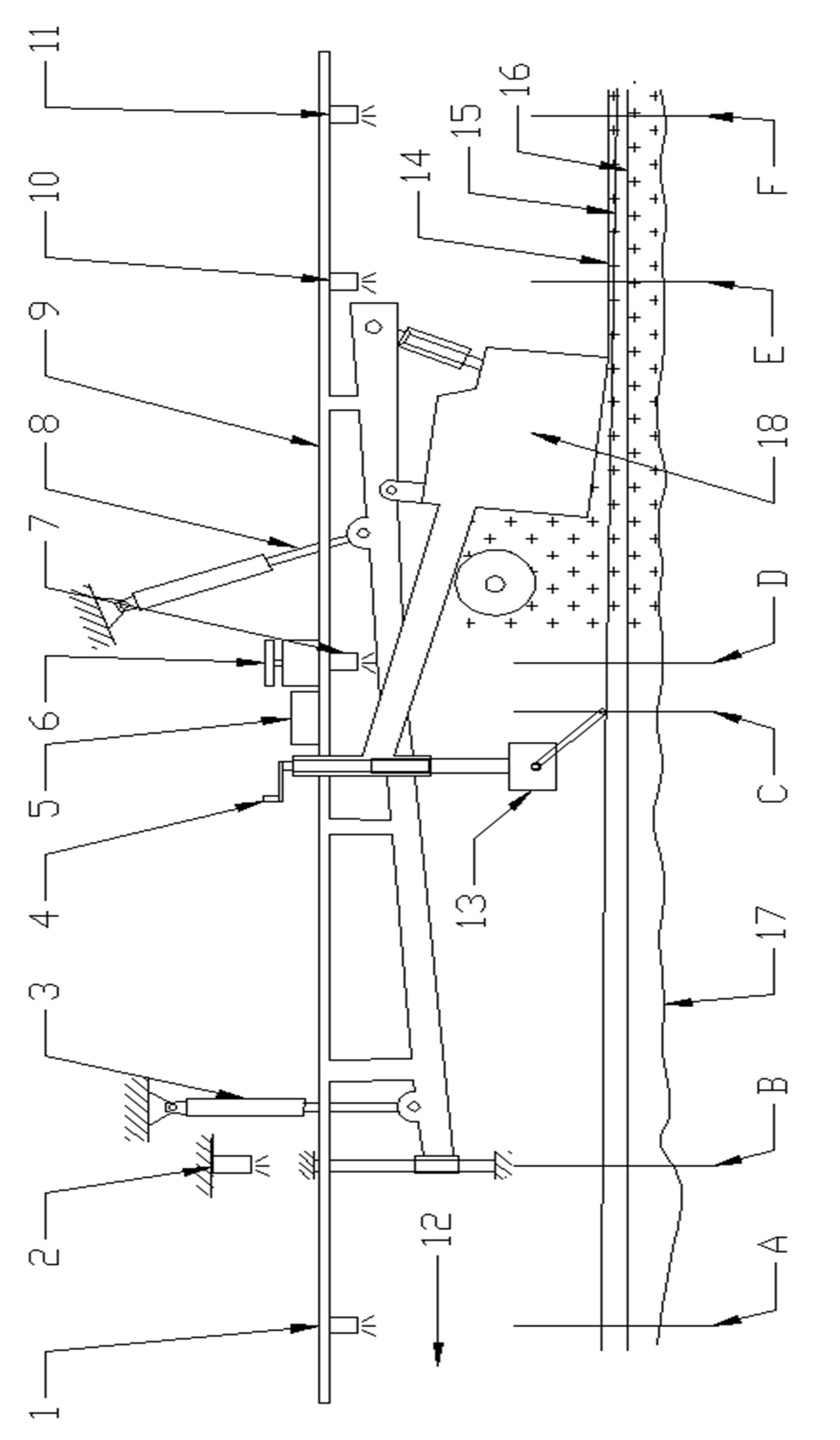
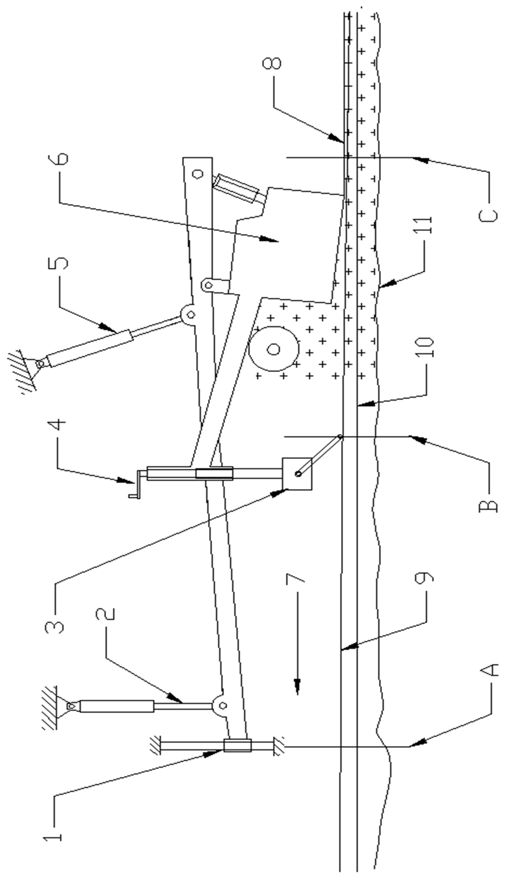
[0053] figure 1 and image 3 They are respectively the elevation schematic diagram and the plane schematic diagram of Embodiment 1 of the present invention. The composition and respective functions of the equipment in Embodiment 1 will be described below.

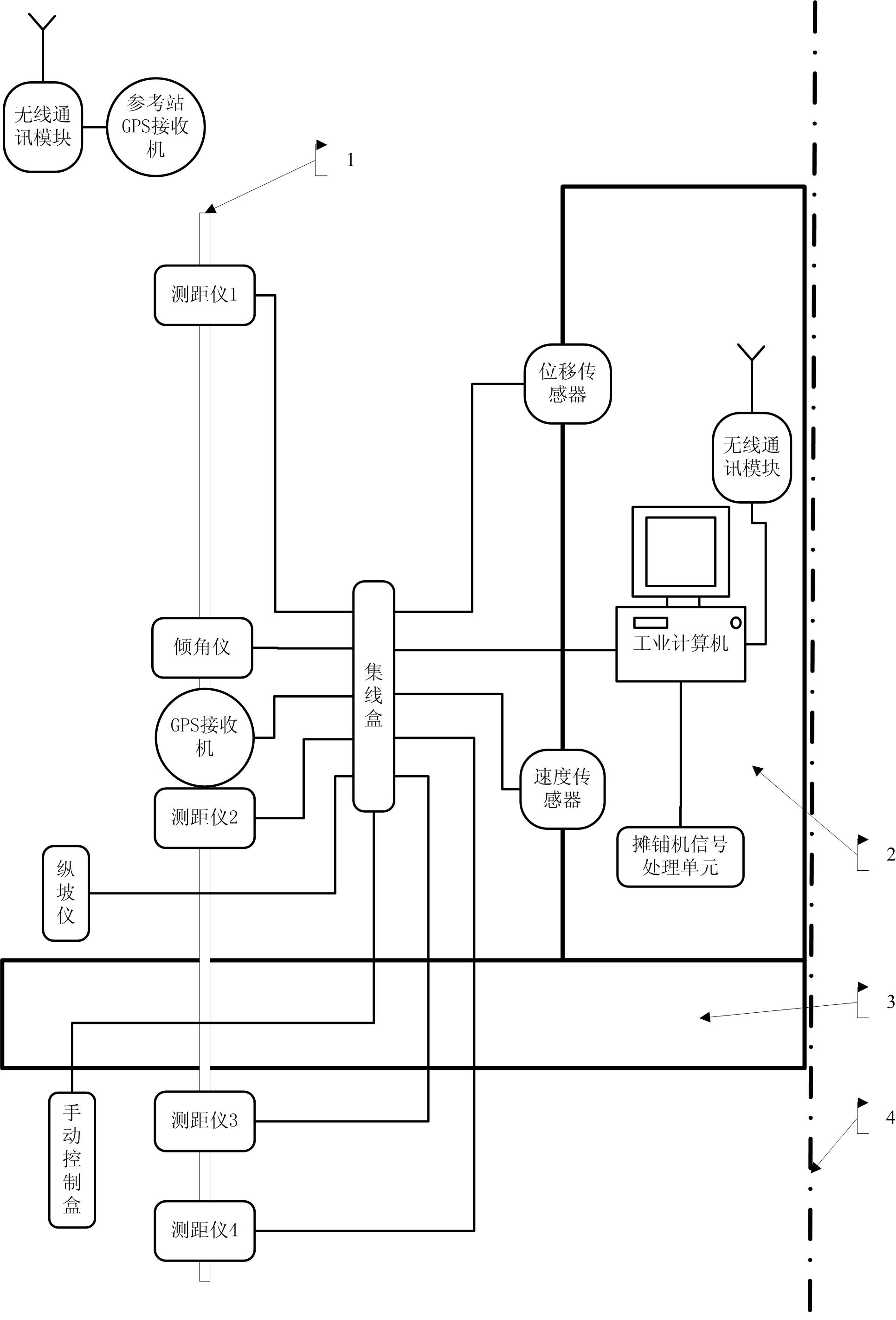
[0054] Such as image 3 As shown, 1 industrial computer, 1 reference station GPS receiver, 1 set of wireless data communication equipment, 1 displacement sensor, 1 speed sensor, 4 range finders, 1 mobile station GPS receiver, 1 longitudinal Slope meter, 1 manual control box and 1 junction box form the semi-width control system of the intelligent GPS elevation and average thickness control system of the floating screed paver, which can work independently and control the paver elevation on one side of the paver. Map No. 4 is the longitudinal center line of the paver. If the other half is also installed with 1 displacement sensor, 1 speed sensor, 4 range finders, 1 mobile station GPS receiver, 1 vertical slope meter, 1 1 ...

Embodiment 2

[0067] On the basis of Example 1, a mobile station GPS receiver is added to the intelligent GPS elevation and average thickness control system of the half-width floating screed paver, the inclinometer is removed, and the two mobile station GPS receivers are respectively installed on the figure 1 The position number 1 and the position number 10 in the map, so that the three-dimensional coordinates of point A17 can be obtained through the GPS receiver and range finder of the 1 position mobile station, and the E14 point can be obtained through the GPS receiver and the range finder of the 1 position mobile station For the three-dimensional coordinates of the points, this embodiment is the same as Embodiment 1 in other respects, except that the method of obtaining the coordinates of the original road surface point and the newly paved road surface point is different.

Embodiment 3

[0069] On the basis of Embodiment 1, the working method of the current RTK surveying GPS receiver is the same, the mobile station GPS receiver directly receives the data of the reference station GPS receiver and corrects its own measurement data in real time, and then sends the corrected data to For industrial computer use. The industrial computer does not undertake the calculation work of RTK.


PUM


Abstract

The invention provides an intelligent elevation and average thickness control system of a floated screed plate paver, and the system provided by the invention comprises an industrial computer, a measuring type GPS receiver, a distance meter, an inclinometer, a displacement transducer, a velocity transducer, a longitudinal slope instrument and other devices. In a GPS mode, design data is input in advance only, a levelling instrument is not required for measuring the elevation of the original ground, an elevation datum line is not erected, and leveling operation hands are not used at two sides of the paver, so that the elevations of the original ground and a newly paved road surface can be accurately recorded; in a compensating beam mode, measured data are participated in calculation of the average thickness for mileage per millimeter, thus the paved thickness can be recorded accurately; and in a longitudinal slope mode, the actual paved thickness can be recorded accurately on the basis of the traditional control method. In addition, the three operating modes can be converted quickly, thus overcoming the defects at the starting stage of the original compensating beam mode, ensuring continuous paving under the condition of abnormal GPS signals, and realizing flexible conversion under the condition of complicated road condition design.

Description

technical field [0001] The invention relates to a control system for the paving elevation and average paving thickness of a floating screed paver. The system uses measuring GPS receivers, speed sensors, displacement sensors, slope gauges, non-contact range finders, industrial computers and other equipment as well as computer software to cooperate with the hydraulic leveling control system of the paver to realize fully automatic road elevation and average paving Thickness control. As long as the design data is input in the system computer control program in advance, there is no need to use a level gauge to measure the original road surface elevation, and there is no need to set up a height reference line as the reference surface of the paver slope gauge, and no leveling operators are required on both sides of the paver. [0002] The floating screed paver referred to in the present invention refers to an asphalt concrete paver or a paver for paving other road-building materials...

Claims


Application Information

Patent Timeline
IPC IPC(8): E01C19/12E01C19/18
Inventor 苌安
Owner 合肥年代智能科技有限公司
Why Eureka
Try Eureka