Permeable band ratio factor-based water depth inversion method

A water depth inversion and waveband technology, which is applied in the reflection/re-radiation of radio waves, radio wave measurement systems, image data processing, etc. Compensate for the effect of reduced calculation accuracy

Active Publication Date: 2011-09-07
哈尔滨哈船导航技术有限公司
View PDF1 Cites 34 Cited by
  • Summary
  • Abstract
  • Description
  • Claims
  • Application Information

AI Technical Summary

Problems solved by technology

A single depth inversion model based on artificial neural network can only conduct sounding for fixed water areas. When the extern...

Method used


Image

  • Permeable band ratio factor-based water depth inversion method
  • Permeable band ratio factor-based water depth inversion method
  • Permeable band ratio factor-based water depth inversion method

Examples


Embodiment Construction

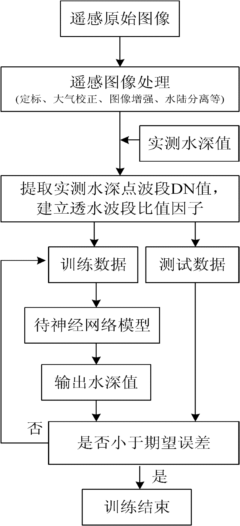
[0027] The present invention will be further described in detail with reference to the accompanying drawings and embodiments.

[0028] The present invention is a water depth inversion method based on the ratio factor of the permeable band, and the process is as follows figure 1 shown, including the following steps:

[0029] Step 1: Perform radiometric calibration on remote sensing images.

[0030] The radiometric calibration of the original remote sensing image can be implemented by using the IKONOS Radiance tool in Calibration Utilities of ENVI to perform radiometric calibration of each band of the IKONOS data. After selecting the IKONOS file to be calibrated in any band, enter the IKONOS satellite type, image imaging time, sun angle height, calibration type and other parameters in the pop-up ENVI IKONOS Calibration dialog box. Among them, the IKONOS satellite type, image imaging time, and sun angle height parameters can be obtained from the metadata.txt file attached to th...


PUM


Abstract

The invention discloses a permeable band ratio factor-based water depth inversion method, which comprises the following steps of: 1, performing radiant calibration on a remote sensing image; 2, performing atmospheric correction on the remote sensing image subjected to the radiant calibration; 3, performing image enhancement on the remote sensing image subjected to the atmospheric correction; 4, performing amphibious separation on the remote sensing image subjected to the image enhancement; 5, performing geometric correction and data processing on the remote sensing image subjected to the amphibious separation; and 6, establishing a neural network water depth inversion model. Compared with a neural network model using single permeable band as input, the permeable band ratio factor-based neural network inversion model has low standard deviation and large related coefficients. The model is not affected by the seawater type and the undersea sediment, and simultaneously has the function ofsolving nonlinear mapping and good promotion capability.

Description

technical field [0001] The invention belongs to the field of shallow water depth remote sensing, and particularly relates to a water depth inversion method based on a ratio factor method of a permeable band without considering the influence of other environmental factors (such as sea bottom quality, sea water type, etc.) near islands and reefs. Background technique [0002] Bathymetry is an essential work in water conservancy, shipping, offshore engineering, water resource utilization, tidal flat development, etc. The traditional bathymetry method is to use the bathymetry equipment installed on the survey ship to measure the water depth of each point in the whole water area, and then calculate and draw the map according to the drawing requirements, so as to obtain the underwater topographic map of the measured water area. Due to the wide coverage of water depth information collection and the harsh environmental conditions in some areas, it is often difficult for sounders to ...

Claims


Application Information

Patent Timeline
IPC IPC(8): G01S7/41G01S7/40G01S13/08G01S13/89G06N3/02G06T5/00G06T7/00
Inventor 张振兴吴迪赵玉新李刚沈志峰刘厂
Owner 哈尔滨哈船导航技术有限公司
Why Eureka
Try Eureka