Groundwater numerical simulation method based on water circulation
A numerical simulation and groundwater technology, applied in electrical digital data processing, special data processing applications, instruments, etc., can solve the problems of affecting simulation accuracy, time-consuming operation, difficult to popularize, etc. The effect of promoting the application
- Summary
- Abstract
- Description
- Claims
- Application Information
AI Technical Summary
Problems solved by technology
Method used
Image


Examples
Embodiment 1
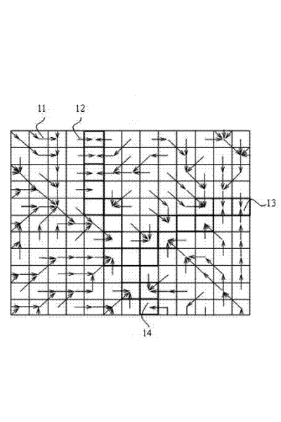
[0033] This embodiment is a large-scale groundwater numerical simulation method based on water cycle simulation. The method described in this embodiment can be compiled as a computer program and run on a PC or other general-purpose computers. The steps of the method described in this embodiment are as follows:
[0034] 1) Steps to establish a water cycle simulation system: use the water cycle simulation method based on the sub-basin spatially discrete model to determine the temporal and spatial distribution of the vertical circulation flux of groundwater in a large-scale area, thereby generating the data required for groundwater numerical simulation information;
[0035] 2) Steps to establish a groundwater numerical simulation system: it is used to simulate the lateral flow of groundwater in the study area by adopting the groundwater numerical simulation system based on the rectangular grid unit spatial discretization technology. The simulation principle is based on the follo...
Embodiment 2
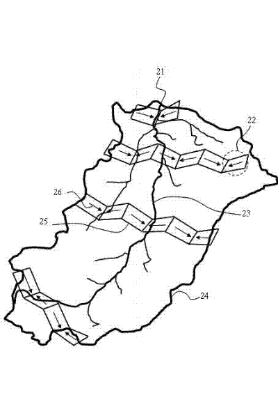
[0093] This embodiment is an improvement of the first embodiment, and is a refinement of the first embodiment regarding spatial nesting processing. The "spatial nesting process" described in this embodiment includes the following sub-steps:
[0094] 1) Determine the spatial relationship between subwatersheds and grid cells. Use ARCGIS or other general geographic information system tools to spatially superimpose the multiple sub-basins divided by the water cycle simulation system and the multiple grid units divided by the groundwater numerical simulation system, so as to obtain the sub-basins and grid units in the simulation area affiliation relationship. That is, for a specific sub-basin, determine the number and position of grid cells that overlap with it and record them. The geographic information system tool is a software tool for analyzing and managing multiple geographic spatial entity data and their relationships, such as ARCGIS, ARCVIEW, MAPGIS, and MAPWINDOW, which a...
Embodiment 3
[0099] This embodiment is an improvement of the first embodiment, and is a refinement of the first embodiment regarding synchronous coupling. As mentioned earlier, synchronous coupling refers to the interactive feedback between two systems completing information within the same time step. A time step is a time segment during simulation or simulation. The entire simulation period is composed of multiple time steps, and the two systems are coupled synchronously for each time step until the end of the simulation. Within a time step, the "synchronous coupling" described in this embodiment includes the following sub-process steps:
[0100] 1) In a time step, the water cycle simulation system first completes the water cycle simulation of this time step, and calculates the various fluxes of the groundwater cycle in each sub-basin, where the vertical circulation flux related to groundwater includes precipitation infiltration Recharge, seepage recharge of surface water bodies such as ...
PUM
 Abstract
Description
Claims
Application Information
 - R&D
- Intellectual Property
- Life Sciences
- Materials
- Tech Scout
- Unparalleled Data Quality
- Higher Quality Content
- 60% Fewer Hallucinations
Browse by: Latest US Patents, China's latest patents, Technical Efficacy Thesaurus, Application Domain, Technology Topic, Popular Technical Reports.
© 2025 PatSnap. All rights reserved.Legal|Privacy policy|Modern Slavery Act Transparency Statement|Sitemap|About US| Contact US: help@patsnap.com