Compressive-sensing-based on-satellite real-time image synthesis compression system

A compressed sensing and real-time image technology, which is applied in image communication, television, electrical components, etc., can solve the problems of large amount of computation and complex compression algorithm process, and achieve accurate and convenient bit rate control, improved stability, and accurate bit rate control Effect

Inactive Publication Date: 2013-01-09
CHANGCHUN INST OF OPTICS FINE MECHANICS & PHYSICS CHINESE ACAD OF SCI
View PDF0 Cites 13 Cited by
  • Summary
  • Abstract
  • Description
  • Claims
  • Application Information

AI Technical Summary

Problems solved by technology

It uses wavelet to transform the image, and then quantizes and encodes the wavelet coefficients. The compression algorithm is complex and the amount of calculation is large, but the image decoding algorithm is simple and easy to implement on a computer platform.

Method used


Image

  • Compressive-sensing-based on-satellite real-time image synthesis compression system
  • Compressive-sensing-based on-satellite real-time image synthesis compression system
  • Compressive-sensing-based on-satellite real-time image synthesis compression system

Examples


Embodiment Construction

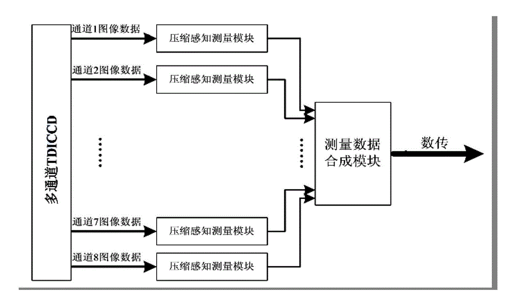
[0025] Such as figure 1 As shown, the compressed sensing-based on-board real-time image synthesis and compression system of the present invention includes: n compressed sensing measurement modules and measurement data synthesis modules.

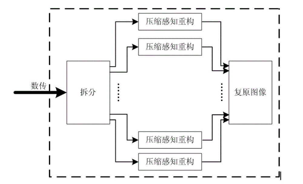
[0026] Satellite remote sensing first performs compressed sensing measurement on the original data of each channel of the multi-channel TDICCD camera on the star to obtain the compressed data, then synthesizes the compressed data, and transmits the synthesized data stream to the ground through the digital transmission module. The ground decomposes and decodes the compressed data stream to obtain the restored image. The specific process is as follows:

[0027] Compression coding of data on 1 star

[0028] According to the compressed sensing theory, the measurement matrix is ​​designed, and the original signal of each channel output by the multi-channel TDICCD is randomly measured through the measurement matrix to obtain the compressed data. ...


PUM


Abstract

The invention relates to a compressive-sensing-based on-satellite real-time image synthesis compression system, which comprises n compressive-sensing measurement modules and a measurement data synthesis module, wherein each compressive-sensing measurement module carries out random measurement on original row image data X output by a corresponding channel of a multichannel TDICCD (Time Delay and Integration Charge Coupled Device) by using a Bernoulli random measurement matrix to obtain compressed measurement data Y; and the measurement data synthesis module synthesizing measurement data Y of all channels into an entire row of compressed image measurement data. According to the invention, the data of each channel of the multichannel TDICCD is compressively sensed on satellite to obtain compressed data to be synthesized and transmitted to the ground, and a complex compressive sensing restructing algorithm is carried out on ground. A complex data recovery algorithm on ground is used to exchange a simple and reliable on-satellite image compression method, so that the work frequency of on-satellite circuits is reduced, and the stability of an on-satellite image integration circuit is improved, and meanwhile, on-satellite hardware resources are saved.

Description

Technical field: [0001] The invention relates to a remote sensing image compression system, in particular to an on-board real-time image synthesis compression system based on compressed sensing. Background technique: [0002] At present, with the continuous development of satellite remote sensing technology and applications, the technical indicators of remote sensing images such as ground resolution, field of view and image quality are getting higher and higher, which has caused the amount of data inside the remote sensing camera to increase exponentially. Data processing poses very big challenges. The solution generally starts from two aspects of hardware and software algorithms. On the hardware side, digital and analog devices with higher processing speed and performance are used, and on the software side, advanced data mathematical technology is used to compress data, such as the current mature digital image compression algorithm. , and sparse algorithms for digital sign...

Claims


Application Information

Patent Timeline
Patent Type & Authority Applications(China)
IPC IPC(8): H04N7/26H04N21/238H04N21/438
Inventor 郭永飞刘春香李宁刘廷霞
Owner CHANGCHUN INST OF OPTICS FINE MECHANICS & PHYSICS CHINESE ACAD OF SCI
Why Eureka
Try Eureka