
Satellite Laser Ranging System

An artificial satellite and laser ranging technology, which is applied in the field of artificial satellite laser ranging system, can solve the problems of limiting the operating frequency of the SLR system and the low signal-to-noise ratio of the system, so as to increase the amount of effective echo data, improve the signal-to-noise ratio, The effect of improving ranging accuracy and ranging ability

Inactive Publication Date: 2017-12-01
CHINESE ACAD OF SURVEYING & MAPPING
View PDF4 Cites 0 Cited by
  • Summary
  • Abstract
  • Description
  • Claims
  • Application Information

AI Technical Summary

Problems solved by technology

[0004] However, the above-mentioned traditional SLR technology that uses a time interval counter to measure the flight time of a single laser pulse, for satellites with different orbital altitudes, the flight time of a laser pulse varies from several milliseconds to hundreds of milliseconds, so the time interval timing technology is limited The operating frequency of the SLR system is limited. For high-orbit satellites, the laser repetition rate can only be below 10Hz. Due to the low laser repetition frequency, the signal-to-noise ratio of the system is low, so that the system can measure high-orbit satellites and low-orbit satellites in the shadow of the earth. low ability

Method used


Image

  • Satellite Laser Ranging System
  • Satellite Laser Ranging System
  • Satellite Laser Ranging System

Examples


Embodiment Construction

[0029] The specific implementation manners of the present invention will be further described in detail below in conjunction with the accompanying drawings and embodiments. The following examples are used to illustrate the present invention, but are not intended to limit the scope of the present invention.

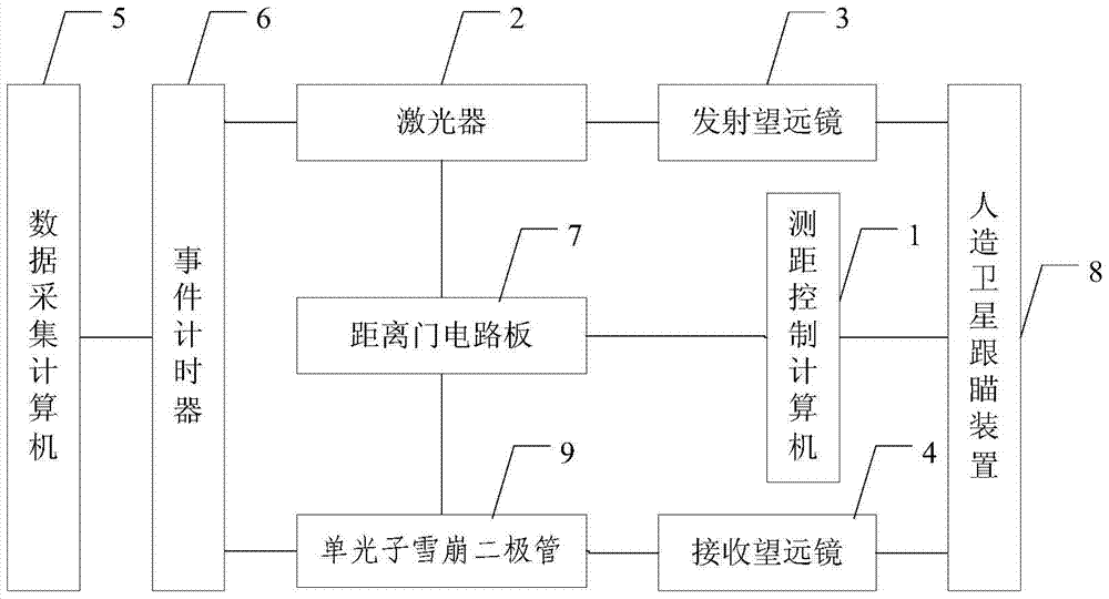
[0030] figure 1 It is a schematic diagram of an artificial satellite laser ranging system provided by an embodiment of the present invention, including a ranging control computer 1, a laser 2, a transmitting telescope 3, a receiving telescope 4, a data acquisition computer 5, an event timer 6, and a range gate circuit board 7. Artificial satellite tracking device 8 and single photon avalanche diode 9;

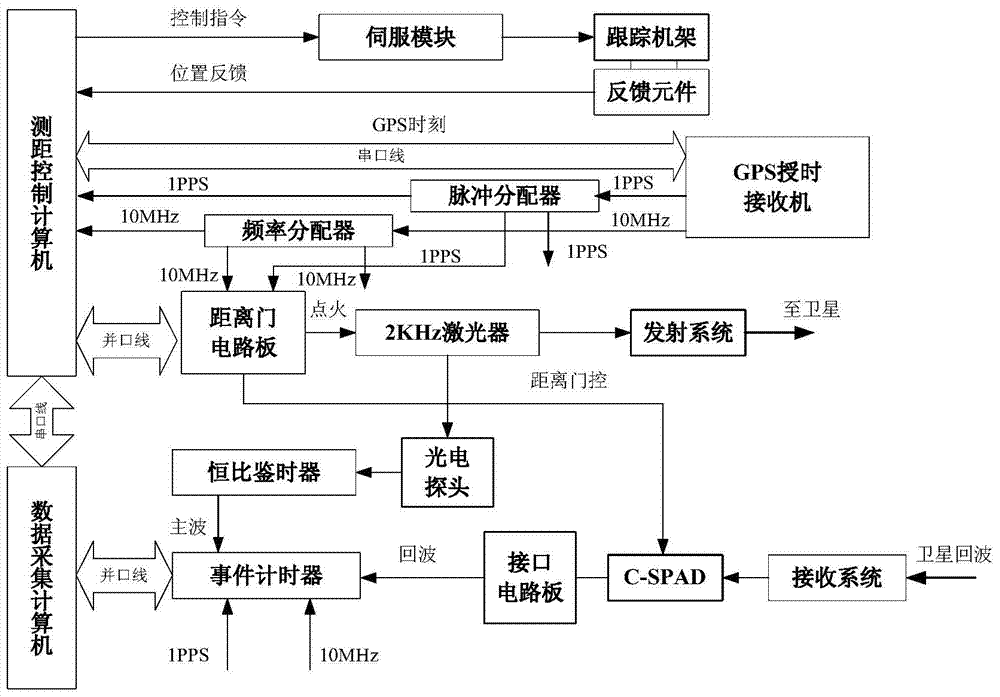
[0031] The ranging control computer calculates the predicted position of the artificial satellite in the station coordinate system in real time and obtains guidance information according to the predicted position, and periodically calculates the laser ignition time and the...


PUM


Abstract

The invention provides an artificial satellite laser ranging system. The artificial satellite laser ranging system is characterized by comprising a ranging control computer, a laser, a transmitter-telescope, a receiving telescope, a data collection computer, an event timer, a range gate circuit board, an artificial satellite tracking and pointing device and a single-photon avalanche diode. By means of the artificial satellite laser ranging system, the event timer records the dominant wave moment and the return wave moment, the signal to noise ratio of the system is greatly improved by application of a high-resolution-ratio and high-precision range door, then the effective return wave data size is improved, and the ranging precision and ranging capacity of the system are improved remarkably.

Description

technical field [0001] The invention relates to the field of laser ranging, in particular to an artificial satellite laser ranging system. Background technique [0002] Satellite laser ranging (SLR) technology is based on the measurement of the flight time of laser pulses starting from the observatory, reflected by a cooperative target (usually a satellite equipped with a retroreflector), and finally returning to the observatory. The measurement accuracy can reach centimeter level or even sub-centimeter level satellite ranging means. [0003] In the existing satellite laser ranging system, the laser pulse generated by the laser is introduced into the transmitting telescope through the meandering optical path and the Cude optical path. A small part of the optical path is taken out, and the electric pulse is formed by the main wave sampling circuit, which is divided into two paths. One is called the main wave pulse. After being shaped by the pulse distributor, it is used as a...

Claims


Application Information

Patent Timeline
Patent Type & Authority Patents(China)
IPC IPC(8): G01S13/18
CPCG01S17/18
Inventor 李谦赵春梅瞿锋卫志斌何正斌
Owner CHINESE ACAD OF SURVEYING & MAPPING
Learn More