Method for quickly calculating atmospheric CO2 concentration based on satellite infrared remote sensing
A carbon dioxide and fast calculation technology, applied in calculation, special data processing applications, instruments, etc., can solve the problems of limited data accuracy, insufficient monitoring and analysis data of greenhouse gas pattern, insufficient monitoring and analysis data, etc.
- Summary
- Abstract
- Description
- Claims
- Application Information
AI Technical Summary
Problems solved by technology
Method used
Image
Examples
Embodiment Construction
[0030] The technical solutions of the present invention will be described in further detail below with reference to the accompanying drawings and specific embodiments.
[0031] The invention discloses a rapid calculation method of atmospheric carbon dioxide concentration based on satellite infrared remote sensing and a carbon dioxide concentration remote sensing inversion system. According to the spectral response function of each observation channel of AIRS (Atmospheric Infrared Sounder), the atmospheric molecular spectral absorption data database HITRAN2008 and the Line by Line radiative transfer model are used to enhance its response performance to greenhouse gases, especially to trace gases such as carbon dioxide and methane. .
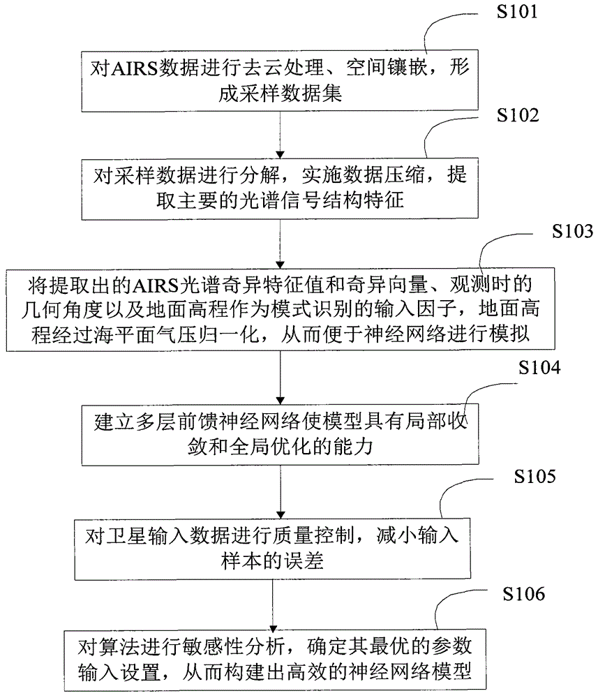
[0032] figure 1 The flow chart of an embodiment of establishing a calculation model for the rapid calculation method of atmospheric carbon dioxide concentration based on satellite infrared remote sensing of the present invention, refer to figure...
PUM
 Abstract
Description
Claims
Application Information
 - R&D
- Intellectual Property
- Life Sciences
- Materials
- Tech Scout
- Unparalleled Data Quality
- Higher Quality Content
- 60% Fewer Hallucinations
Browse by: Latest US Patents, China's latest patents, Technical Efficacy Thesaurus, Application Domain, Technology Topic, Popular Technical Reports.
© 2025 PatSnap. All rights reserved.Legal|Privacy policy|Modern Slavery Act Transparency Statement|Sitemap|About US| Contact US: help@patsnap.com


