Data fusion method for flush air data system and inertial navigation system

An inertial navigation system and air data technology, applied in the field of aircraft navigation system design, can solve the problems of inability to reduce the risk of embedded air data systems, high requirements for air data measurement accuracy, and high requirements for aerodynamic model accuracy, and achieve output Continuous results, strong versatility, and good safety

Active Publication Date: 2015-11-18
CHINA ACAD OF LAUNCH VEHICLE TECH
View PDF4 Cites 31 Cited by
  • Summary
  • Abstract
  • Description
  • Claims
  • Application Information

AI Technical Summary

Problems solved by technology

Among the above three approaches, the first two approaches are mainly used to improve the dynamic performance of air data measurement, which have high requirements on the accuracy of air data measurement and can

Method used


Image

  • Data fusion method for flush air data system and inertial navigation system
  • Data fusion method for flush air data system and inertial navigation system
  • Data fusion method for flush air data system and inertial navigation system

Examples


Example Embodiment

[0045] Specific embodiments of the present invention will be further described in detail below in conjunction with the accompanying drawings.

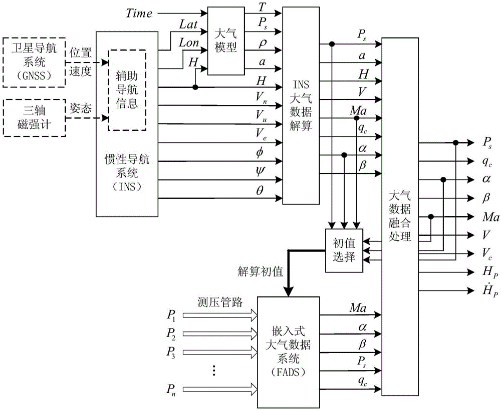
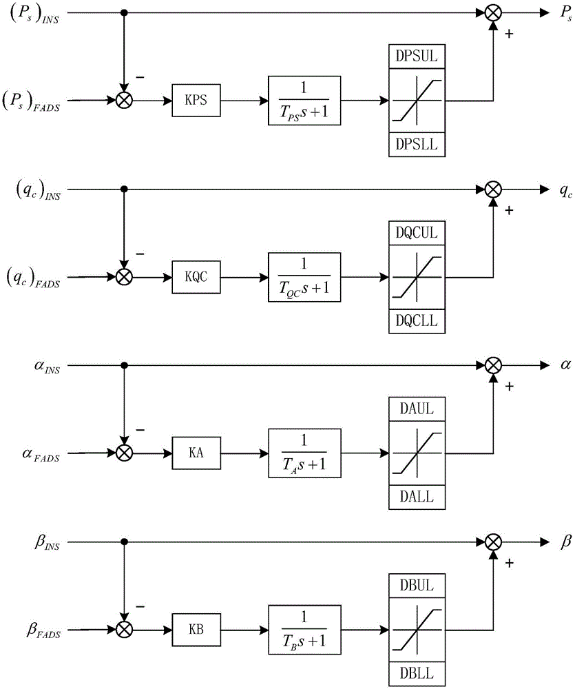
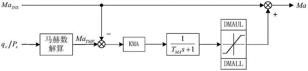
[0046] The present invention proposes a data fusion method of an embedded air data system and an inertial navigation system, such as figure 1 As shown, the steps are as follows:

[0047] (1) Collect the navigation information output by the inertial navigation system, the navigation information includes geodetic latitude Lat, geodetic longitude Lon, geodetic height H, northward speed V n , Celestial velocity V u , East speed V e , roll angle φ, yaw angle ψ and pitch angle θ;

[0048] North speed V n , Celestial velocity V u and the eastward velocity V e is the component of the flight speed of the aircraft relative to the earth in the geographic coordinate system. The roll angle φ, yaw angle ψ and pitch angle θ are the Euler angles from the geographic coordinate system to the body coordinate system.

[0049] Geographic coordinate...


PUM


Abstract

The invention discloses a data fusion method for a flush air data system and an inertial navigation system. The method comprises the steps that 1, navigation information outputted by the inertial navigation system is collected; 2, the air temperature, the static pressure, the density and the sound velocity are calculated on the basis of a selected air model according to the navigation information; 3, the true airspeed, the mach number, the dynamic pressure, the attack angle and the sideslip angle are calculated according to the navigation information, the air temperature, the static pressure, the density and the sound velocity; 4, a resolving initial value is selected according to an air data resolving result of the inertial navigation system at the current moment and an air data fusion processing result at the last moment; 5, the mach number, the attack angle, the sideslip angle, the static pressure and the dynamic pressure are resolved according to the resolving initial value and a surface pressure value at a pressure tap of a flight vehicle; 6, the air data resolving data of the inertial navigation system and a resolving result of the flush air data system are fused. According to the data fusion method for the flush air data system and the inertial navigation system, the common problems existing in the flush air data system can be solved, and the air data measuring performance can be improved.

Description

technical field [0001] The invention relates to a data fusion method of an embedded air data system and an inertial navigation system, which can improve the measurement performance of aircraft air data and belongs to the field of aircraft navigation system design. Background technique [0002] During orbital or suborbital reentry, the thermal environment is harsh during high-speed flight, and the nose pitots, L-shaped probes, cone probes, or wind vanes of conventional air data systems cannot meet the thermal protection requirements. The embedded air data system (FlushAirDataSystem, FADS) calculates atmospheric parameters by measuring the surface pressure of the aircraft. It has strong adaptability to thermal environmental conditions and does not interfere with the external flow field of the aircraft. It is especially suitable for hypersonic aircraft. However, the embedded air data system usually uses a complex aerodynamic model in the process of air data calculation. The aer...

Claims


Application Information

Patent Timeline
IPC IPC(8): G01C21/16G01M9/06
CPCG01C21/165G01M9/06
Inventor 袁利平吕天慧张莽朱如意李永远张月玲王征孙光张春阳吴俊辉黄喜元郑宏涛谢泽兵杨勇朱永贵
Owner CHINA ACAD OF LAUNCH VEHICLE TECH
Why Eureka
Try Eureka