
Wireless sensor network-based monitoring and positioning system for radionuclide-contaminated water and soil

A wireless sensor and radionuclide technology, applied in satellite radio beacon positioning systems, radio wave measurement systems, signal transmission systems, etc., can solve problems such as GPS failure and signal loss, achieve convenient wireless deployment, improve timeliness, Small size effect

Active Publication Date: 2015-12-16
NANHUA UNIV
View PDF6 Cites 1 Cited by
  • Summary
  • Abstract
  • Description
  • Claims
  • Application Information

AI Technical Summary

Problems solved by technology

The disadvantage is that the traditional GPS can only work in the occasions where the satellite signal is good. Once the signal attenuates or the signal is lost, the GPS will fail

Method used


Image

  • Wireless sensor network-based monitoring and positioning system for radionuclide-contaminated water and soil
  • Wireless sensor network-based monitoring and positioning system for radionuclide-contaminated water and soil
  • Wireless sensor network-based monitoring and positioning system for radionuclide-contaminated water and soil

Examples


Embodiment Construction

[0018] Specific embodiments of the present invention will be described in detail below in conjunction with specific drawings. It should be noted that the technical features or combinations of technical features described in the following embodiments should not be regarded as isolated, and they can be combined with each other to achieve better technical effects.

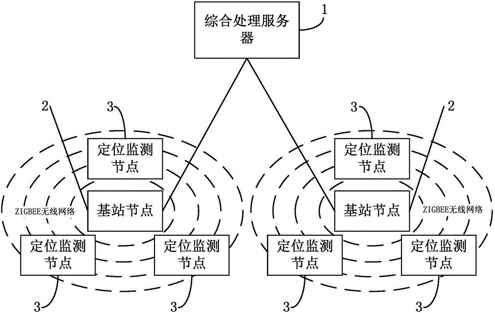
[0019] Such as figure 1 As shown, the present invention provides a radionuclide water and soil pollution monitoring and positioning system based on a wireless sensor network, including a positioning monitoring node 3, a base station node 2 and an integrated processing server 1; the base station node 2 is used to communicate with the positioning monitoring node 3; The integrated processing server 1 is connected to the base station node 2 through a wired network; ZIGBEE standard communication is adopted between the positioning monitoring nodes 3 and between the positioning monitoring node and the base station node 2;

...


PUM


Abstract

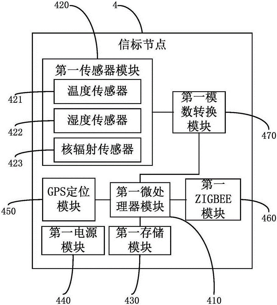
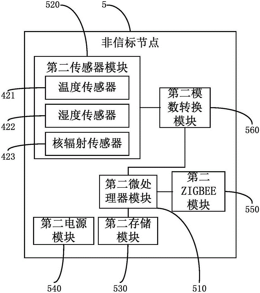
The invention discloses a wireless sensor network-based monitoring and positioning system for radionuclide-contaminated water and soil. The system comprises positioning and monitoring nodes, a base station node and a comprehensive processing server, wherein the base station node is used for communication with the positioning and monitoring nodes, the comprehensive processing server is connected with the base station node through a wired network, the positioning and monitoring nodes are communicated with the base station node through the ZIGBEE standard, the positioning and monitoring nodes are composed of beacon nodes and non-beacon nodes, and each beacon node comprises a GPS positioning module, a first microprocessor module, a first memory module, a first ZIGBEE module, a first sensor module, a first analog-to-digital conversion module and a first power supply module. The wireless sensor network-based monitoring and positioning system has greatly improved practicality; since the system is based on GPS-ZIGBEE dual-mode positioning technology, platform expansibility is good, a plurality of nodes can be loaded at the same time, and a variety of sensors can be loaded; and the system has the characteristics of low energy consumption, long stand-by time, a small size, light weight, portability and adaptivity to a variety of severe environments.

Description

technical field [0001] The invention belongs to the field of radioactive uranium tailing pond pollution monitoring, and in particular relates to a radionuclide water and soil pollution monitoring and positioning system based on a wireless sensor network. Background technique [0002] The radioactive source can emit rays with strong penetrating power, and has a wide range of applications: in medical treatment, it can irradiate human tumors and kill cancer cells; in agriculture, it can irradiate agricultural products, sterilize and prevent corrosion; in metal industry, it can be used to find welding metals flaws, and carry out industrial flaw detection; measuring instruments such as material level gauges and nuclear scales made of radioactive sources are less affected by environmental factors such as temperature and humidity, and operate reliably; but radioactive sources are also a double-edged sword. Improper operation or storage during the application process may cause accid...

Claims


Application Information

Patent Timeline
Patent Type & Authority Applications(China)
IPC IPC(8): G01N33/24G08C17/02G01S19/46
Inventor 余修武李向阳谢水波江珊余员琴范飞生李睿
Owner NANHUA UNIV
Learn More