Road survey device

A road and sensor technology, used in measuring devices, measuring instruments, surveying and navigation, etc., can solve problems such as hidden dangers to personal safety, inability to intuitively reflect the relationship between data points, and complex survey data procedures.

Inactive Publication Date: 2016-10-26
青岛安正网络科技有限公司
View PDF9 Cites 2 Cited by
  • Summary
  • Abstract
  • Description
  • Claims
  • Application Information

AI Technical Summary

Problems solved by technology

[0002] Before the road transportation of heavy equipment, it is necessary to select a suitable transportation route. The basis for choosing a transportation route is that the transportation vehicles of heavy equipment must meet the restrictive requirements for the height, width and arc of road structures such as roads, bridges and tunnels on the transportation route. The accuracy of road survey is high; in the existing technology, road survey methods include picture survey and laser survey: picture survey is based on the picture taken by the camera, and the image content is calculated according to the ratio of the camera position and the image taken by the camera. The height and width of all objects, and then generate a three-dimensional map based on the calculation results and images. Image surveys are mostly used for three-dimensional modeling of urban buildings and terrains. There are high survey costs and low survey accuracy. The accuracy of survey results is easily affected by light, latitude and longitude and Issues such as the influence of external factors such as air humidity; laser surveying is based on the principle of laser reflection to calculate the distance between the laser head and the target object, and is mostly used for surveying transportation routes with fewer points. There are the following problems: First, the survey results are point-like The distribution of the data cannot directly reflect the relationship between each data point. The second is that the whole process of survey is manual operation. Human factors have a great impact on the accuracy of the survey results, and the survey efficiency is low. There are hidden dangers to the personal safety of the staff when surveying in a dangerous environment. The third is that the post-processing of the survey data is complicated, which leads to poor timeliness of the survey results.

Method used


Image

  • Road survey device

Examples


Embodiment

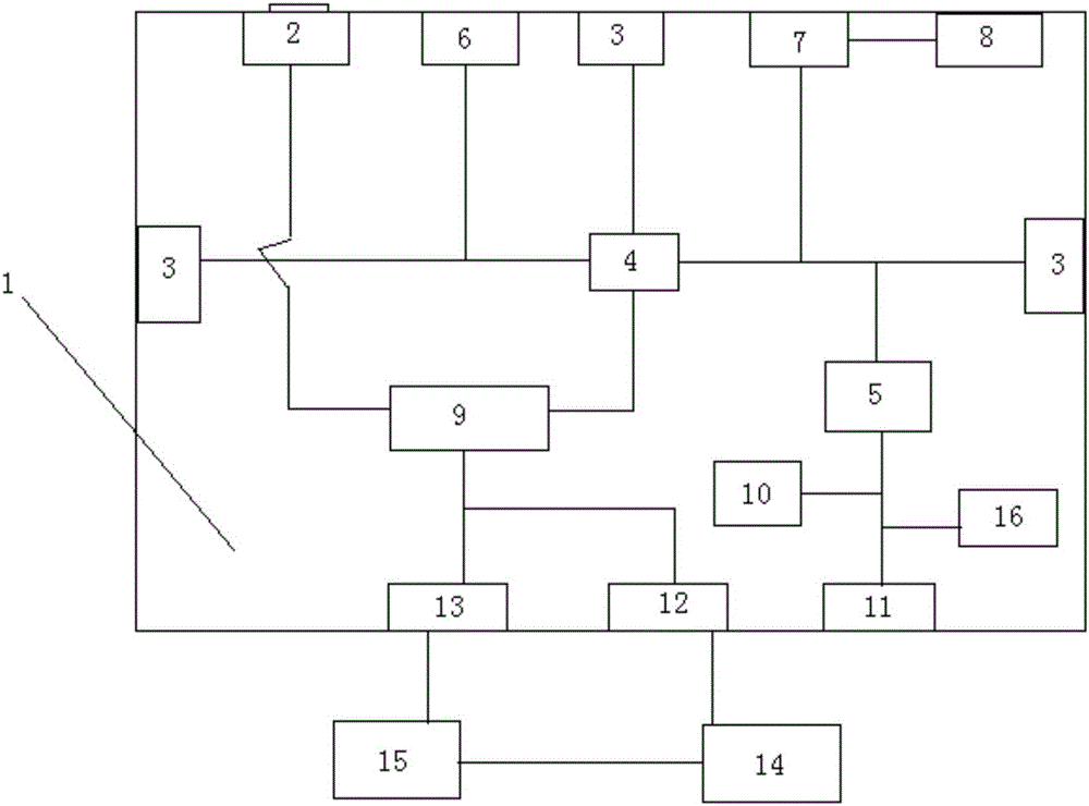
[0012] The main structure of the road surveying device involved in this embodiment includes an equipment box 1, a video camera 2, a distance sensor 3, a server 4, a temperature and humidity controller 5, an angle sensor 6, a converter 7, a GPS module 8, and a data switch 9. Warmer 10, cooling exhaust fan 11, network cable interface 12, power line interface 13, terminal 14, battery 15 and temperature and humidity sensor 16; on the inner surface of the front side wall of the equipment box 1 with the hollow cuboid structure A camera 2, a distance sensor 3, an angle sensor 6, a converter 7 and a GPS module 8 are provided. The camera part of the camera 2 is on the outer surface of the front side wall of the equipment box 1, and the left and right side walls of the equipment box 1 A distance sensor 3 is respectively arranged on the inner surface, a server 4, a temperature and humidity controller 5, a data switch 9, a heater 10 and a temperature and humidity sensor 16 are arranged on ...


PUM


Abstract

The invention belongs to the technical field of road survey equipment, and relates to a road survey device. According to the road survey device, a main body structure comprises an equipment box, a camera, a distance sensor, a server, a temperature-humidity controller, an angle sensor, a converter, a GPS module, a data switching exchange, a heater, a cold exhaust fan, a network wire interface, a power supply wire interface, a terminal, a storage battery and a temperature-humidity sensor. The road situation of a surveyed route can be automatically monitored in real time, images of survey nodes can be taken, data information such as widths, heights, longitudes and latitudes and radians of surveyed roads and barriers on roads can be surveyed, the data information validity can be verified in real time, operation such as data information recording, calling and query is supported, and moreover, due to a constant temperature and humidity environment in the heat-preservation type equipment box, normal operation of different components is ensured, and the integrality and the stability are improved; the road survey device is simple in structure, precise in survey result, visible and easy to use, good in stability, long in service life, high in survey efficiency, low in cost, good in application environment, and wide in application range.

Description

Technical field: [0001] The invention belongs to the technical field of road surveying equipment, and relates to a road surveying device, which can automatically survey the latitude and longitude, height, width and radian of road structures such as roads, bridges and tunnels, and provide a basis for selecting transportation routes for heavy items. Background technique: [0002] Before the road transportation of heavy equipment, it is necessary to select a suitable transportation route. The basis for choosing a transportation route is that the transportation vehicles of heavy equipment must meet the restrictive requirements for the height, width and arc of road structures such as roads, bridges and tunnels on the transportation route. The accuracy of road survey is high; in the existing technology, road survey methods include picture survey and laser survey: picture survey is based on the picture taken by the camera, and the image content is calculated according to the ratio o...

Claims


Application Information

Patent Timeline
Patent Type & Authority Applications(China)
IPC IPC(8): G01C15/00
CPCG01C15/00
Inventor 程欢
Owner 青岛安正网络科技有限公司
Why Eureka
Try Eureka