Eureka AIR delivers breakthrough ideas for toughest innovation challenges, trusted by R&D personnel around the world.

High-resolution remote sensing image fusion evaluation method based on diffusion tensor guidance

A remote sensing image, high-resolution technology, applied in the field of remote sensing image fusion, can solve the problems of not taking into account the consistency of multispectral images and panchromatic images, overlapping images without strict correspondence, and the decline of spatial detail expressiveness, etc., to avoid inability to The effect of reading into memory problems, reducing running time, and avoiding false structure phenomena

Inactive Publication Date: 2016-11-23
WUHAN UNIV
View PDF3 Cites 12 Cited by
  • Summary
  • Abstract
  • Description
  • Claims
  • Application Information

AI Technical Summary

Problems solved by technology

Existing studies have shown that while most of the current image fusion algorithms try to keep the spectral characteristics of the fused image consistent with the original multispectral image, the expressiveness of the spatial details will be reduced to a certain extent.
The reason is that most methods need to upsample the multispectral image to the same resolution as the panchromatic image in the preprocessing step. However, the commonly used upsampling methods do not take into account the geometric consistency of the multispectral image and the panchromatic image. The overlapping images are not strictly corresponding, and false structures often appear near the edge of the feature and small features
[0004] The existing remote sensing image acquisition platform is developing towards multi-satellite, multi-sensor, high spatial resolution, high spectral resolution and short return visit cycle, resulting in geometric growth of acquired remote sensing data, and traditional CPU parallel programming can no longer meet the needs of application systems for data processing. The efficiency and accuracy requirements of

Method used


Image

  • High-resolution remote sensing image fusion evaluation method based on diffusion tensor guidance
  • High-resolution remote sensing image fusion evaluation method based on diffusion tensor guidance
  • High-resolution remote sensing image fusion evaluation method based on diffusion tensor guidance

Examples


Embodiment Construction

[0044] The technical solutions of the present invention will be further specifically described below through the embodiments and in conjunction with the accompanying drawings.

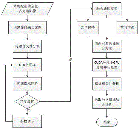
[0045] see figure 1 , the embodiment of the present invention provides a method for fusion and evaluation of high-resolution remote sensing images guided by scattered tensor, comprising the following steps:

[0046] Step 1: Block the multispectral image and panchromatic image after image registration. The image block size of the multispectral image is 512×512 pixels, and the image block size of the panchromatic image is 2048×2048 pixels. There is a one-to-one correspondence between the image blocks of the multispectral image and the image blocks of the panchromatic image. The input data in the embodiment has been strictly registered, and the file to be fused can be created and stored, and the data of each band of the multispectral and panchromatic images are stored in the file according to the block r...


PUM


Abstract

The invention provides a high-resolution remote sensing image fusion evaluation method based on diffusion tensor guidance. The method includes the steps that a multispectral image and a panchromatic image which are subjected to image registration are segmented, an anisotropic model is adopted to carry out up-sampling under diffusion tensor guidance, a remote sensing image fusion algorithm is selected, GPU parallel computing acceleration is adopted, and remote-sensing image fusion evaluation index correlation analysis is carried out. According to the method, the action intensity of a diffusion tensor model on image pixels can be regulated with parameters in the up-sampling process, and thus edge protection and noise removal can be balanced according to actual demands; up-sampling is not influenced by the imaging quality such as the brightness and the contrast ratio of an original image, strict correspondence of overlapped images is achieved, and the phenomenon of false structures of pixels near the edge is avoided; besides, a generalized model is proposed to generalize the fusion strategy, and the quality of an obtained fused image is comprehensively evaluated through correlation analysis; the performance of existing equipment is fully exerted, and multithread processing is carried out by utilizing the computing advantage of high strength of a GPU.

Description

technical field [0001] The invention belongs to the technical field of remote sensing image fusion, in particular to a high-resolution remote sensing image upsampling fusion method based on diffusion tensor guidance. Background technique [0002] Multispectral remote sensing images play an important role in the fields of agriculture, forestry, mining, and the environment. However, due to the limitations of the radiation transfer process and sensor technology, their spatial resolution is low, and it is difficult to obtain ground object details well. On the other hand, high-resolution remote sensing satellites can obtain sub-meter-level earth observations, but their images can only provide information in the panchromatic band. Therefore, satellite platforms are often equipped with multi-spectral and panchromatic high-resolution sensors at the same time, and effectively synthesize the multi-spectral information and detailed information on the ground through image fusion to prov...

Claims


Application Information

Patent Timeline
Patent Type & Authority Applications(China)
IPC IPC(8): G06T7/00G06T3/00G06T5/00G06T1/60
CPCG06T1/60G06T7/0002G06T2207/20021G06T2207/10036G06T2207/10041G06T2207/30181G06T2207/20221G06T3/14G06T5/70
Inventor 潘励谈家英
Owner WUHAN UNIV
Why Eureka
Eureka Blog
Learn More