A UAV Pose Estimation Method Based on Trapezoid and Circular Landmarks

A pose estimation and UAV technology, applied in the field of image processing, can solve the problems of inability to obtain UAV flight elevation information and attitude parameters accurately and in real time, difficult to ensure positioning accuracy, and slow processing speed, etc., to achieve timeliness Strong performance, high estimation accuracy, exact solution effect

Active Publication Date: 2021-10-22
HARBIN INST OF TECH
View PDF5 Cites 0 Cited by
  • Summary
  • Abstract
  • Description
  • Claims
  • Application Information

AI Technical Summary

Problems solved by technology

[0003] At present, the UAV system usually carries GPS data to obtain its own position, but it is difficult to ensure the accuracy of positioning, and it is impossible to obtain the elevation information and attitude parameters of the UAV during flight accurately and in real time.
Although there are currently researches on pose estimation methods and algorithms based on binocular vision, template matching, feature tracking, color segmentation, and horizon detection, there are still problems such as complex calculations and slow processing speeds, which are difficult to support practical engineering applications.

Method used


Image

  • A UAV Pose Estimation Method Based on Trapezoid and Circular Landmarks
  • A UAV Pose Estimation Method Based on Trapezoid and Circular Landmarks
  • A UAV Pose Estimation Method Based on Trapezoid and Circular Landmarks

Examples


specific Embodiment approach 1

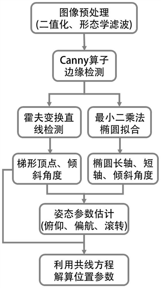
[0031] Specific Embodiment 1: This embodiment describes a UAV pose estimation method based on a combination of trapezoid and circle landmarks, which can be applied to UAV autonomous attitude control, automatic landing, etc., by combining trapezoid and circle into a landmark pattern, and its estimation flow chart is as follows figure 1 , the method steps are as follows:

[0032] Step 1: UAV binarizes the landmark pattern imaging to segment the landmark pattern, and removes isolated noise based on morphological filtering;

[0033] Step 2: Extract the edge of the landmark, use the Hough transform to extract the straight line information of the trapezoidal contour in the landmark, use the least square method to fit the ellipse equation and calculate the ellipse parameters;

[0034] Step 3: Solve the UAV attitude parameters according to the ellipse parameters calculated in Step 2;

[0035] Step 4: Use the UAV attitude parameters in Step 3 to establish a UAV ground imaging model, ...

specific Embodiment approach 2

[0036] Specific embodiment two: a kind of UAV pose estimation method based on trapezoidal and circular combination landmark described in specific embodiment one, the specific steps of step one are as follows:

[0037] (1) Perform image binarization

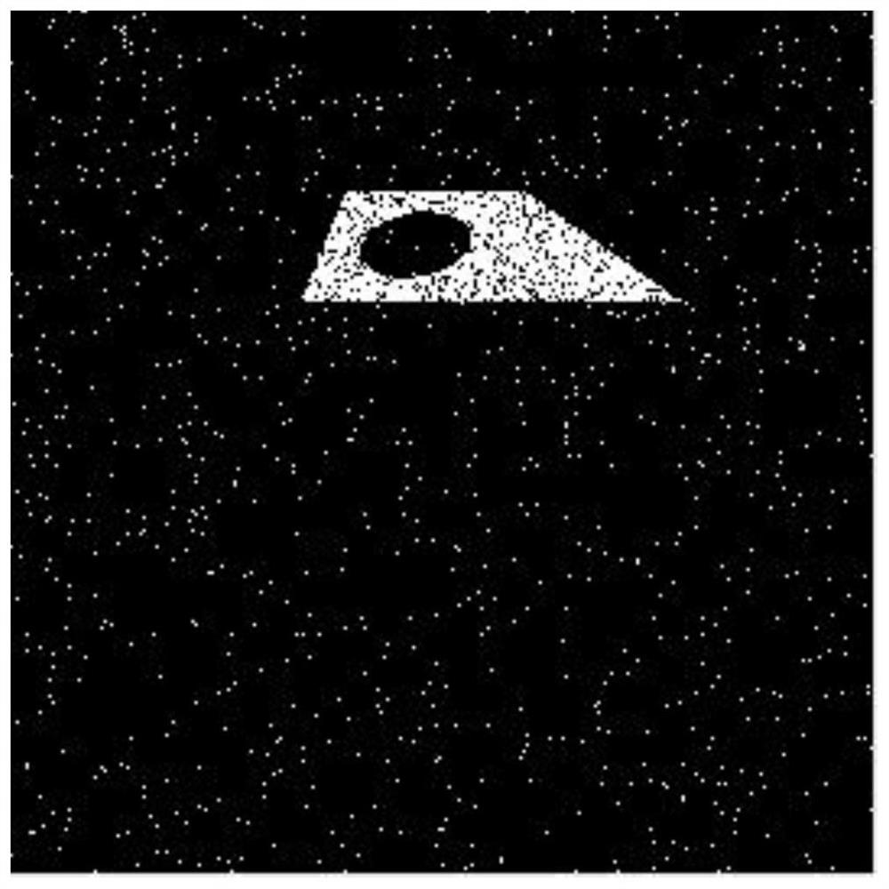
[0038] A threshold is set for the ground imaging results of the UAV. Pixels whose gray value is greater than or equal to the threshold can be regarded as target graphics, and their gray value is represented by 1. Pixels whose gray value is smaller than the threshold are judged as The background area, its gray value is represented by 0;

[0039]

[0040] Among them, f represents the input image, Th is the binarization threshold; x, y represent the pixel coordinates; the binarized image of the imaging result is as follows figure 2 shown;

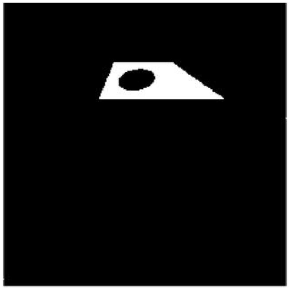
[0041] (2) Morphological filtering

[0042] The binarized image processed by step (1) is successively subjected to opening and closing operations to remove isolated noise, and the processin...

specific Embodiment approach 3

[0043] Specific embodiment three: a kind of UAV pose estimation method based on trapezoidal and circular combination landmark described in specific embodiment one, the specific steps of step two are as follows:

[0044] (1) Based on the Canny operator, edge detection is performed on the binarized image after step 1 morphological filtering, and trapezoidal and elliptical contours are extracted;

[0045] (2) Set the coordinate point of the ellipse contour (x 1 ,y 1 ),(x 2 ,y 2 ),…(x n ,y n ), the normal equation can be obtained by using the least square method:

[0046]

[0047] Among them, A, B, C, D, E are the undetermined coefficients of the elliptic contour curve equation, is the matrix transpose of the normal equation coefficient matrix, [·] T is matrix transpose;

[0048] Normal equation coefficient matrix:

[0049]

[0050] Using the normal equation to obtain the undetermined coefficients, the equation of the elliptic contour curve is:

[0051] Ax 2 +Bxy...


PUM


Abstract

A method for estimating the pose of an unmanned aerial vehicle based on a combination of trapezoidal and circular landmarks belongs to the technical field of image processing. The method is as follows: Step 1, UAV binarizes landmark pattern imaging to segment landmark patterns, and removes isolated noise based on morphological filtering; Step 2, extracts landmark edges, and uses Hough transform to extract trapezoidal contour line information in landmarks , use the least squares method to fit the ellipse equation and calculate the ellipse parameters; step 3, estimate the attitude parameters of the UAV according to the ellipse parameters calculated in step 2; step 4, establish the UAV ground imaging model, and use the trapezoidal contour line information The coordinates of the four vertices of the trapezoid estimate the position parameters. The present invention aims at the problems of precise estimation of pose and autonomous landing in UAV visual navigation, based on the combination of trapezoidal and circular landmark patterns, estimating the attitude parameters according to the geometric imaging characteristics, simplifying the collinear equation solution model, and then solving the position parameters , the calculation process is simple and more suitable for practical engineering applications.

Description

technical field [0001] The invention belongs to the technical field of image processing, in particular to a method for estimating the pose of an unmanned aerial vehicle based on a combination of trapezoidal and circular landmarks. Background technique [0002] With the continuous development of UAVs and the information processing technology carried on them and the transformation of military strategic thinking, UAVs have been widely used in military applications due to their day and night availability, flexible maneuverability, convenient use, low cost, and high efficiency ratio. Military and civilian fields such as reconnaissance, regional surveillance, geographic surveying and mapping, intelligent transportation, power line inspection, and agricultural plant protection. At the same time, UAVs also have the possibility of posing a major threat to areas such as important military sites, airports, and large-scale exhibitions. Therefore, accurate and real-time acquisition of th...

Claims


Application Information

Patent Timeline
Patent Type & Authority Patents(China)
IPC IPC(8): G06T7/73G06T7/13G06T5/00G06T5/30
CPCG06T5/002G06T5/30G06T2207/20036G06T2207/20061G06T7/13G06T7/73
Inventor 智喜洋牛锐泽江世凯张伟郭维峰
Owner HARBIN INST OF TECH
Why Eureka
Try Eureka