High-resolution SAR terrain classification method based on multiscale convolution and feature fusion

A feature fusion and ground object classification technology, applied in the field of high-resolution SAR ground object classification, can solve the problems of low classification accuracy, over-fitting, and less input information, so as to alleviate the phenomenon of over-fitting, improve classification accuracy, and reduce parameters. Effect

Active Publication Date: 2018-06-12
XIDIAN UNIV
View PDF6 Cites 37 Cited by
  • Summary
  • Abstract
  • Description
  • Claims
  • Application Information

AI Technical Summary

Problems solved by technology

This method can automatically learn non-noise robust features without manual feature design, and can be trained end-to-end to improve the accuracy of image classification, but this method is only input due to ZAC whitening of the original SAR grayscale and principal component information, the input information is less, and the model has more network parameters in the fully connected layer, which is prone to overfitting for small sample classification. In addition, the features extracted by this method lack multi-scale information, resulting in low classification accuracy.

Method used


Image

  • High-resolution SAR terrain classification method based on multiscale convolution and feature fusion
  • High-resolution SAR terrain classification method based on multiscale convolution and feature fusion
  • High-resolution SAR terrain classification method based on multiscale convolution and feature fusion

Examples


Embodiment Construction

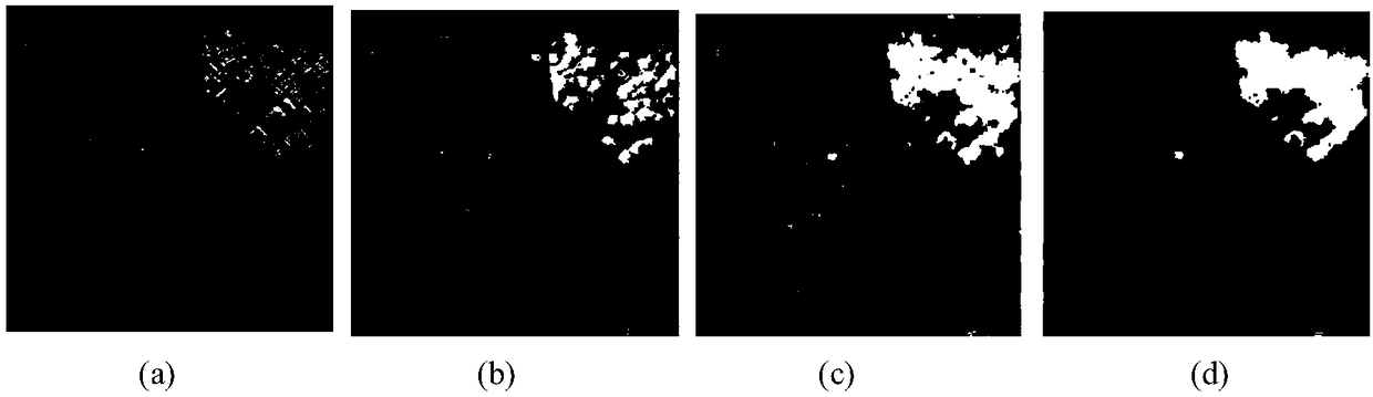
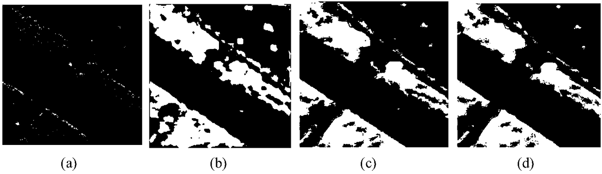
[0032] Below in conjunction with accompanying drawing and embodiment the realization step of the present invention and experimental effect are described in further detail:

[0033] refer to figure 1 , the implementation steps of this example are as follows:

[0034] Step 1: Extract texture features from the image F to be classified.

[0035] SAR image texture feature extraction methods include texture feature extraction methods based on non-subsampling wavelet decomposition, texture feature extraction methods based on gray level co-occurrence matrix, and texture feature extraction methods based on gray level-gradient co-occurrence matrix. This embodiment uses but It is not limited to the texture feature extraction method based on the gray level co-occurrence matrix, and its implementation is as follows:

[0036] (1a) Select 4 discrete directions: 0°, 45°, 90° and 135°, and extract a 15×15 pixel block centered on each pixel point in the image F to be classified. 4 co-occurre...


PUM


Abstract

The invention discloses a high-resolution SAR terrain classification method based on multiscale convolution and feature fusion, and mainly aims at solving the problem in the prior art that the classification precision is low and overfitting easily occurs. The high-resolution SAR terrain classification method comprises the steps of 1, extracting textural features and wavelet features of to-be-classified images; 2, fusing the to-be-classified images, the textural features and the wavelet features to constitute a fusion feature matrix; 3, according to the fusion feature matrix, constructing a training dataset and a testing dataset; 4, adding a multiscale convolution layer and a shuffle layer to an existing CNN network, changing a full-joint layer into a convolution layer, and constructing a multiscale convolution fusion network; 5, using the training dataset to train the multiscale convolution fusion network to obtain model parameters; 6, using the model parameters to initialize the multiscale fusion network to classify a test set. By means of the high-resolution SAR terrain classification method based on the multiscale convolution and the feature fusion, the parameters of the networkare reduced, the overfitting phenomenon of a small sample problem is solved, the classification precision is improved, and the high-resolution SAR terrain classification method can be applied to high-resolution SAR image terrain classification.

Description

technical field [0001] The invention belongs to the technical field of image processing, in particular to a high-resolution SAR object classification method, which can be applied to the fields of image interpretation, target recognition and target tracking, and the like. Background technique [0002] SAR radar satellite is a general term for earth observation remote sensing satellites carrying synthetic aperture radar SAR. SAR's all-weather, all-time and imaging characteristics that can penetrate some ground objects show its superiority compared with optical remote sensors. Radar remote sensing data has also been widely used in multidisciplinary fields, and can be applied to many fields such as military affairs, agriculture, navigation, and geographical surveillance. The SAR image is a representation of the scattering characteristics of radar waves, and it is a reflection of ground objects. The speckle noise in the image is manifested on a uniform surface, and the pixels ap...

Claims


Application Information

Patent Timeline
Patent Type & Authority Applications(China)
IPC IPC(8): G06K9/62
CPCG06F18/214G06F18/241G06F18/253
Inventor 侯彪焦李成张永昌马晶晶马文萍王爽白静
Owner XIDIAN UNIV
Why Eureka
Try Eureka