Rapid satellite image stretching deformation detection method based on GPU-CPU (graphics processing unit-central processing unit) collaboration

A detection method and satellite image technology, which are applied in the field of optical remote sensing satellite image processing, can solve the problems of omission, low efficiency of drawing area search, affecting the efficiency of digital orthophoto map production, etc. The effect of quality inspection efficiency

Active Publication Date: 2018-06-29
CHONGQING GEOMATICS & REMOTE SENSING CENT
View PDF3 Cites 8 Cited by
  • Summary
  • Abstract
  • Description
  • Claims
  • Application Information

AI Technical Summary

Problems solved by technology

The texture distortion caused by the drawing deformation directly affects the quality of the digital orthophoto map, especially in mountainous areas, the drawing deformation is particularly serious, which directly affects the efficiency of digital orthophoto map production
[0004] At present, in the domestic and foreign literature and patents, there is no automatic detection method for the deformation of the optical satellite orthophoto. In the normal production of digital orthophotos, if the deformation of the pattern occurs, it needs to be identified and searched manually. Then it is processed by modifying the DEM and then correcting it
However, the optical satellite remote sensing image has a large frame size. For example, the coverage of a Worldview2 satellite image can reach 280 square kilometers. It will be very time-consuming to rely on manual visual identification to find the latte area, and it may also be missed due to artificial reasons. , so the search efficiency of the optical remote sensing satellite orthophoto image is very low

Method used


Image

  • Rapid satellite image stretching deformation detection method based on GPU-CPU (graphics processing unit-central processing unit) collaboration
  • Rapid satellite image stretching deformation detection method based on GPU-CPU (graphics processing unit-central processing unit) collaboration
  • Rapid satellite image stretching deformation detection method based on GPU-CPU (graphics processing unit-central processing unit) collaboration

Examples


Embodiment Construction

[0058] The specific implementation manner and working principle of the present invention will be further described in detail below in conjunction with the accompanying drawings.

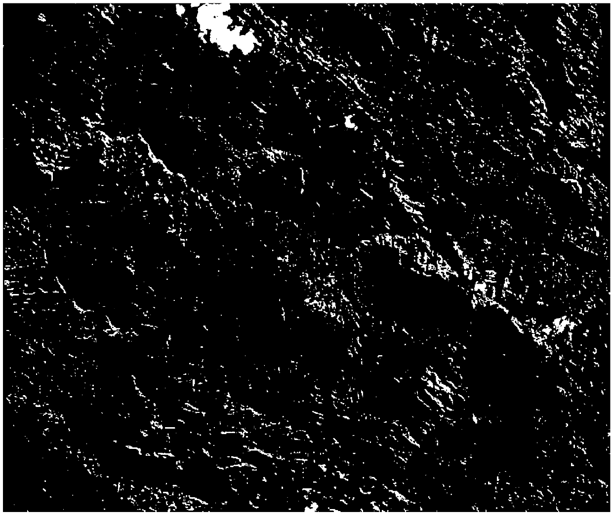
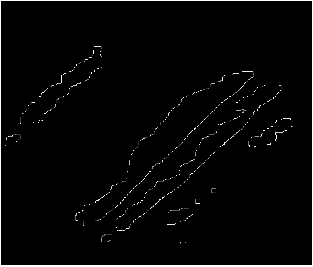
[0059] This embodiment combines a WorldView2 satellite image with a resolution of 0.5 meters in a mountainous area, with a frame size of 36821*36132, a size of 3.3GB, and a ground coverage of about 330Km 2 , the method of the present invention is described in detail.

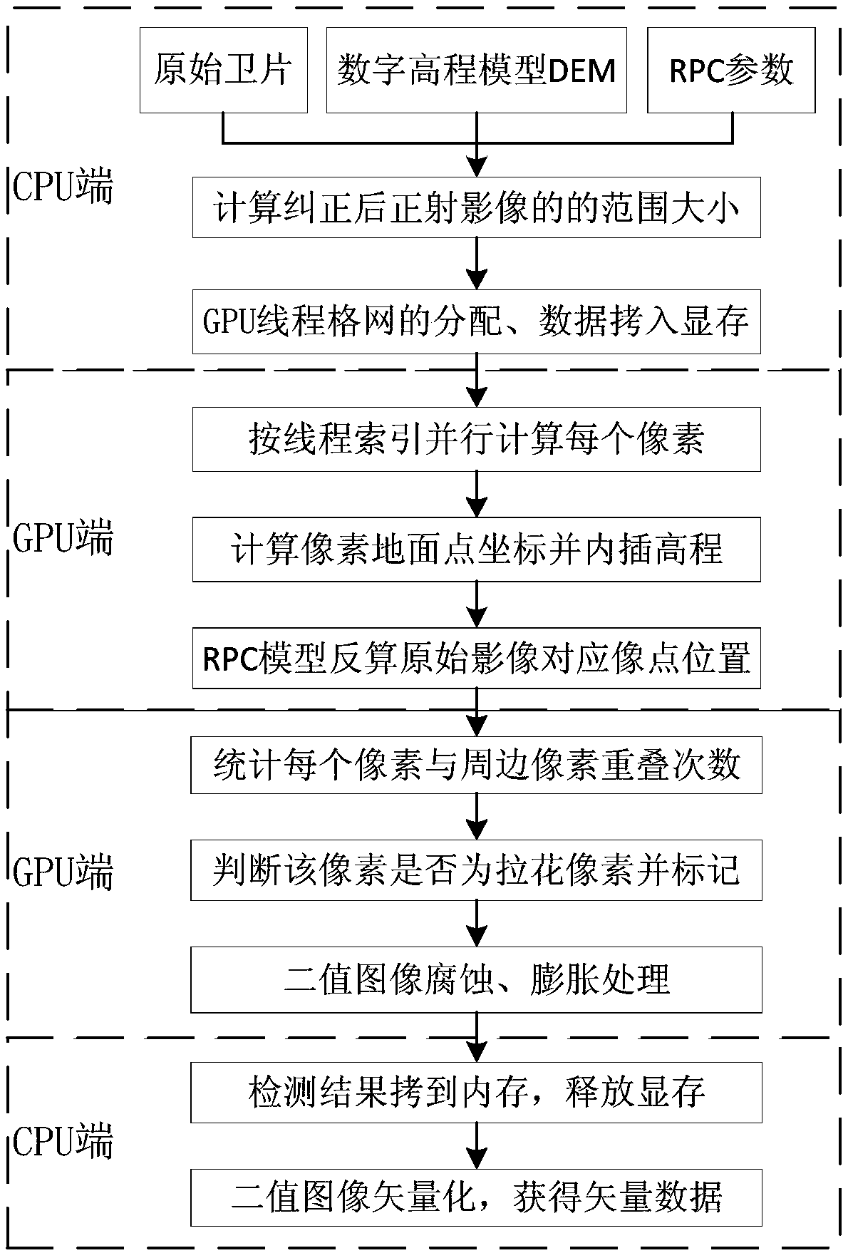
[0060] Such as figure 1 As shown, a rapid detection method of satellite image latte deformation based on GPU-CPU cooperation, the specific steps are as follows:

[0061] Step 1: Load the original satellite images, RPC parameters and digital elevation model DEM on the CPU side, and iteratively solve the range size of the orthophoto after orthorectification;

[0062] During specific implementation, the calculation steps of the size and range of the orthophoto after the orthorectification are as follows:

[0063] Step 1-1: Affine trans...


PUM


Abstract

The invention discloses a rapid satellite image stretching deformation detection method based on GPU-CPU (graphics processing unit-central processing unit) collaboration. The method comprises steps asfollows: a CPU terminal loads an original satellite image, RPC (rational polynomial coefficient) parameters and DEM (digital elevation model) and solves the size and range of a corrected orthoimage through iteration; the CPU terminal designs allocation of a GPU thread grid and copies corresponding data to a corresponding video memory from an internal memory; a GPU terminal performs parallel computing on pixel coordinates, corresponding to the original satellite image, of each pixel according to the thread grid; the GPU terminal counts the overlapping times of current pixels and surrounding pixels and performs stretching pixel judgment; the GPU terminal performs corrosion processing and expansion processing on a binary image according to the thread grid; the CPU terminal copies a binary image result to the internal memory from a global memory and vectorizes the binary image result to obtain vector data of a stretching deformation area. The method has the remarkable effects that rapid automatic detection of the stretching deformation area in a satellite image is realized, and the lookup and quality control efficiency of stretching deformation in the optical remote sensing satelliteorthoimage is greatly improved.

Description

technical field [0001] The invention relates to the technical field of optical remote sensing satellite image processing, in particular to a rapid detection method for latte deformation of satellite images based on GPU-CPU cooperation. Background technique [0002] Digital Orthophoto Map (DOM) is obtained by using optical remote sensing images combined with terrain data (Digital Elevation Model DEM) to calculate the relationship between ground points and original optical remote sensing image pixels pixel by pixel according to the corresponding mathematical model, and then grayscale resampling. An image map with both correct position information and rich texture information. The original optical remote sensing images for making digital orthophoto maps can be divided into two categories according to the acquisition methods: optical satellite remote sensing images and low altitude aerial photography images. The imaging methods, mathematical models and processing methods of the...

Claims


Application Information

Patent Timeline
Patent Type & Authority Applications(China)
IPC IPC(8): G06T7/00G06T7/11G06T7/187G06T1/20G06T1/60
CPCG06T1/20G06T1/60G06T7/0002G06T7/11G06T7/187G06T2200/28G06T2207/30181
Inventor 李朋龙丁忆胡艳张泽烈徐永书李静罗鼎张灿
Owner CHONGQING GEOMATICS & REMOTE SENSING CENT
Why Eureka
Try Eureka