Method and system for detecting and calculating uwb anchor point coordinates
What is Al technical title?
Al technical title is built by PatSnap Al team. It summarizes the technical point description of the patent document.
A technology of coordinate system and measurement system, applied in the field of ranging, which can solve complex and time-consuming problems
Inactive Publication Date: 2019-04-09
BEIJING BOOCAX TECH CO LTD
View PDF9 Cites 8 Cited by
Summary
Abstract
Description
Claims
Application Information
AI Technical Summary
This helps you quickly interpret patents by identifying the three key elements:
Problems solved by technology
Method used
Benefits of technology
Problems solved by technology
[0008] The usual practice is to mark the installation position of the anchor points through the indoor floor plan, and then determine the coordinates of all
Method used
Image
Click on the blue label to locate the original text in one second.
Reading with bidirectional positioning of images and text.
Examples
Embodiment 1
[0082] All anchors have two functions: respond to ranging; initiate ranging for a target. Tag program, the main function of the tag program is: to initiate a distance measurement for a certain target; without changing the above functions, we change the tag program to an algorithm that automatically detects and calculates the coordinates of the uwb anchor point, and the special tag Defined as a detector.
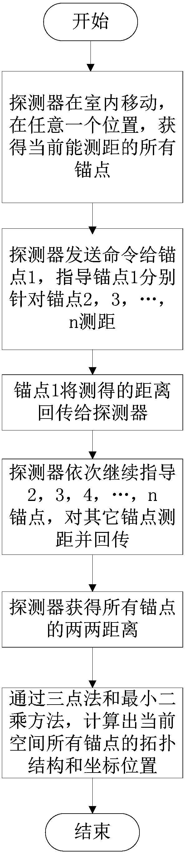
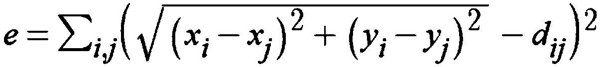
[0083] attached Figure 1-2 It can be seen that a method for detecting and calculating uwb anchor point coordinates, which adopts uwb anchor point, uwb tag and detector, and the detector locates the tag by ranging, comprises the following steps:
[0084] Step 1. The detector moves indoors. At any position, obtain all the anchor points that can be measured currently. Assume that there are n anchor points in the current range, marked as 1, 2, 3, ..., n;
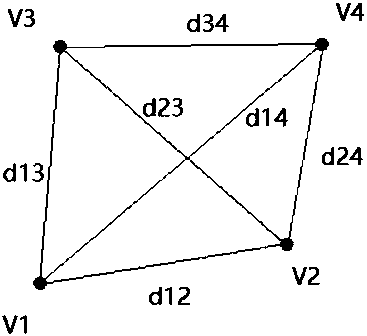
[0085] Step 2, the detector sends a command to anchor point 1, instructing anchor point 1 to measure distances for anchor ...
Embodiment 2
[0116] All anchors have two functions: respond to ranging; initiate ranging for a target. Tag program, the main function of the tag program is: to initiate a distance measurement for a certain target; without changing the above functions, we change the tag program to an algorithm that automatically detects and calculates the coordinates of the uwb anchor point, and the special tag Defined as a detector.
[0117] A measurement system for detecting and calculating the coordinates of uwb anchor points, including uwb anchor points, uwb tags and detectors, there are n anchor points, which are configured to receive ranging commands sent by the detectors, perform ranging according to the instructions, and The measured distance is sent back to the detector; the uwb tag is configured to receive the detector signal in real time and report the tag information to the detector; the detector is configured to locate the uwb tag by obtaining the position of the uwb anchor point for distance m...
PUM
Abstract
The invention relates to a method and system for detecting and calculating uwb anchor point coordinates. The method adopts uwb anchor points, a uwb label and a detector, and the label is positioned bythe detector through distance measurement. The method comprises the following steps that the detector moves indoors, obtains all anchor points which can be subjected to distance measurement currentlyat any position, and guides each anchor point to conduct distance measurement at the other anchor points under the condition that n anchor points exist in the current range; the anchor point 1 transmits a measured distance back to the detector; a topological structure and the coordinate position of all the anchor points in the current space are calculated through a three-point method and a leastsquare method after the detector obtains the distance between every two anchor points. According to the method for detecting and calculating the uwb anchor point coordinates, the positions of anchor points in a measurement area can be quickly captured in real time, and a topological structure diagram of all anchor points in the current area is established. Measurement is convenient, measurement errors are reduced, measurement efficiency and measurement precision are improved, labor intensity of measurement personnel is reduced, and measurement cost is reduced.
Description
technical field [0001] The present invention relates to a distance measuring method and system, in particular to a method and system for detecting and calculating uwb anchor point coordinates. Background technique [0002] UWB (Ultra Wideband) is a carrier-free communication technology that uses nanosecond to picosecond non-sinusoidal narrow pulses to transmit data. UWB was used in short-distance high-speed data transmission in the early days. In recent years, foreign countries have begun to use its sub-nanosecond ultra-narrow pulse for short-distance precise indoor positioning. [0003] UWB wireless communication is a method of communication using pulses with very short time intervals (less than 1ns) without a carrier, also known as Impulse Radio, Time Domain or Carrier Free communication . Compared with ordinary binary phase-shift keying (BPSK) signal waveform, UWB method does not use cosine wave for carrier modulation and sends many pulses less than 1ns, so this communi...
Claims
Application Information
Patent Timeline
Application Date:The date an application was filed.
Publication Date:The date a patent or application was officially published.
First Publication Date:The earliest publication date of a patent with the same application number.
Issue Date:Publication date of the patent grant document.
PCT Entry Date:The Entry date of PCT National Phase.
Estimated Expiry Date:The statutory expiry date of a patent right according to the Patent Law, and it is the longest term of protection that the patent right can achieve without the termination of the patent right due to other reasons(Term extension factor has been taken into account ).
Invalid Date:Actual expiry date is based on effective date or publication date of legal transaction data of invalid patent.