Method for inverting estuarine wetland water environment elements through hyperspectral sensor on unmanned aerial vehicle

A hyperspectral, water environment technology, applied in the field of water environment simulation, can solve the problems of inability to obtain the content of water environment elements, inability to obtain inversion results, increase data redundancy, etc., to achieve large subjective initiative, predictive ability and robustness. The effect of strong performance and improved spatial resolution

Active Publication Date: 2019-05-10
CAPITAL NORMAL UNIVERSITY
View PDF4 Cites 9 Cited by
  • Summary
  • Abstract
  • Description
  • Claims
  • Application Information

AI Technical Summary

Problems solved by technology

However, due to the low spectral reflectance of the water body, the small changes in the content of various elements in the tidal trench have a very slight impact on the spectral curve, and the content of the water environment elements cannot be obtained by directly analyzing the spectral curve; in addition, the spectra...

Method used


Image

  • Method for inverting estuarine wetland water environment elements through hyperspectral sensor on unmanned aerial vehicle
  • Method for inverting estuarine wetland water environment elements through hyperspectral sensor on unmanned aerial vehicle
  • Method for inverting estuarine wetland water environment elements through hyperspectral sensor on unmanned aerial vehicle

Examples


Embodiment 1

[0054] Example 1: Reference figure 1 ;

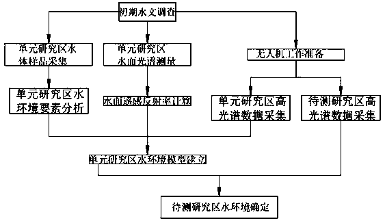
[0055] The method of inverting water environment elements of estuarine wetlands by using hyperspectral sensors on UAVs includes the following steps:

[0056] S1. The estuary wetland with a large area of ​​tidal ditch is used as the study area to be tested, and the hydrological survey is carried out, and an appropriate small area of ​​tidal ditch area is selected as the unit study area;

[0057] S2. Collection of water body samples in the unit study area; multiple groups of sampling points are arranged in the unit study area, and on the sampling points, water samples 0-0.5 meters below the water surface of the sampling points are collected by a water collector;

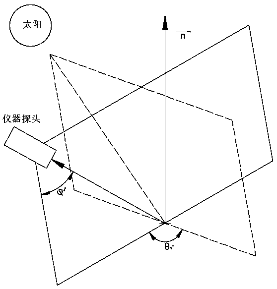
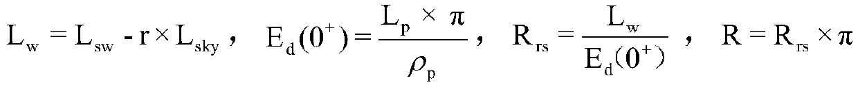
[0058] S3. Calculation of the water surface remote sensing reflectance of the unit study area; using the ground object spectrometer with reference to the spectral measurement method above the water surface to collect spectral data at the sampling point and calculate the water s...

Embodiment 2

[0092] In step S4, the water sample collected in step S2 is transferred to the laboratory for data analysis of water environment elements, including the determination of suspended matter mass, total salt content, determination of chlorophyll a concentration, and total nitrogen content. The measurement of total phosphorus content and the determination of total phosphorus content, etc.; take the water sample of group A to be tested and measure the suspended matter mass by "gravimetric method". The substance on the membrane is dried at 103°-105° and weighed to calculate the amount of suspended matter in the water sample; the water sample of group B to be tested is taken to measure the total salt content by the "gravimetric method", and a certain volume of water sample is passed through WhatmanGF / F filter membrane with a pore size of about 0.45μm is used for filtration and pretreatment, using a ceramic evaporating dish as a container, 0.1-0.2g anhydrous sodium carbonate as a dehy...

Embodiment 3

[0093] Embodiment 3: In step S5, the flight preparations are first performed, and the flight route position and flight height are planned according to the area of ​​the unit study area to ensure that the side overlap of adjacent flight zones reaches more than 50%. According to the flight height and the UAV hyperspectral sensor The parameter calculates the ground sampling distance; black (reflectivity 5%) and white (reflectivity 65%) non-woven fabrics are arranged in the flat and open area of ​​the unit study area as dark and bright targets. This material has good Lambertian properties and can be used instead of The traditional diffuse reflection reference plate is used as the radiation calibration material; the size of the non-woven fabric must be at least 10 times larger than the ground sampling distance to ensure that it can be clearly identified in the image. According to the position of the navigation belt, 5 to 6 image control points are arranged around each air belt, and ...


PUM


Abstract

The invention discloses a method for inverting estuarine wetland water environment elements through a hyperspectral sensor on an unmanned aerial vehicle, and belongs to the field of water environmentsimulation. According to the method for inverting the estuarine wetland water environment elements through the hyperspectral sensor on the unmanned aerial vehicle, the estuarine wetland water environment elements are quickly calculated out in combination with the use of the unmanned aerial vehicle through the steps of collecting a water body sample of a unit research area, calculating the remote sensing reflectance of the water surface of the unit research area, analyzing a water environment of the unit research area, making unmanned aerial vehicle work preparation, collecting hyperspectral data of the unit research area, building a water environment model of the unit research area, collecting hyperspectral data of a to-be-tested research area, determining a water environment of the to-be-tested research area, and the like; the above steps are repeated to establish multiple groups of water quality content distribution images of the estuarine wetland research areas; and the change rulesof the water quality of the estuarine wetland research areas are compared and obtained in the same direction, so that the tidal creek water quality change conditions which are quickly and dynamicallychanged can be accurately captured, and the time and labor are saved.

Description

technical field [0001] The invention relates to the field of water environment simulation, in particular to a method for inverting water environment elements of estuarine wetlands by using a hyperspectral sensor on an unmanned aerial vehicle. Background technique [0002] Estuarine wetlands are located in the ecological crossroads between river ecosystems and marine ecosystems. Under the interaction of salt and fresh water, estuarine wetlands play the role of corridors, filters and barriers for the logistics, energy flow, information flow and biological flow between rivers and marine ecosystems, and have unique ecological value and resource potential. The water-sediment, water-salt, chlorophyll a, total nitrogen, and total phosphorus in the salt-water interaction zone are the key water environment elements of estuarine wetlands, and their distribution in time and space directly reflects the two-way action mode of tidal current and runoff in estuarine wetlands. As well as th...

Claims


Application Information

Patent Timeline
IPC IPC(8): G01N21/17G01N21/55G06F17/18
CPCY02A20/152
Inventor 柯樱海李鹏周德民王明丽吕明苑陈盟盟
Owner CAPITAL NORMAL UNIVERSITY
Why Eureka
Try Eureka