Real-time ionosphere modeling and monitoring method based on regional CORS

An ionospheric and regional technology, applied in the field of global navigation satellite system satellite positioning, can solve problems such as limited correction accuracy, low accuracy, and inability to perform real-time correction, and achieve the effect of accelerating convergence time and improving positioning accuracy.

Inactive Publication Date: 2019-05-31
SOUTHEAST UNIV
View PDF4 Cites 26 Cited by
  • Summary
  • Abstract
  • Description
  • Claims
  • Application Information

AI Technical Summary

Problems solved by technology

The IGS data processing center establishes a global ionospheric model and generates grid products through the observation data of more than 200 base stations around the world. However, when the model is applied to a small area, the accuracy is not high, and the real-time performance is insufficient, so it cannot be corrected in real time
In addition, due to the complex changes in the ionosphere, the empirical model established based on long-term observation data cannot better reflect the changes in the ionosphere, so the correction accuracy is limited

Method used


Image

  • Real-time ionosphere modeling and monitoring method based on regional CORS
  • Real-time ionosphere modeling and monitoring method based on regional CORS
  • Real-time ionosphere modeling and monitoring method based on regional CORS

Examples


Embodiment Construction

[0044] The present invention will be further described below in conjunction with the accompanying drawings and specific embodiments.

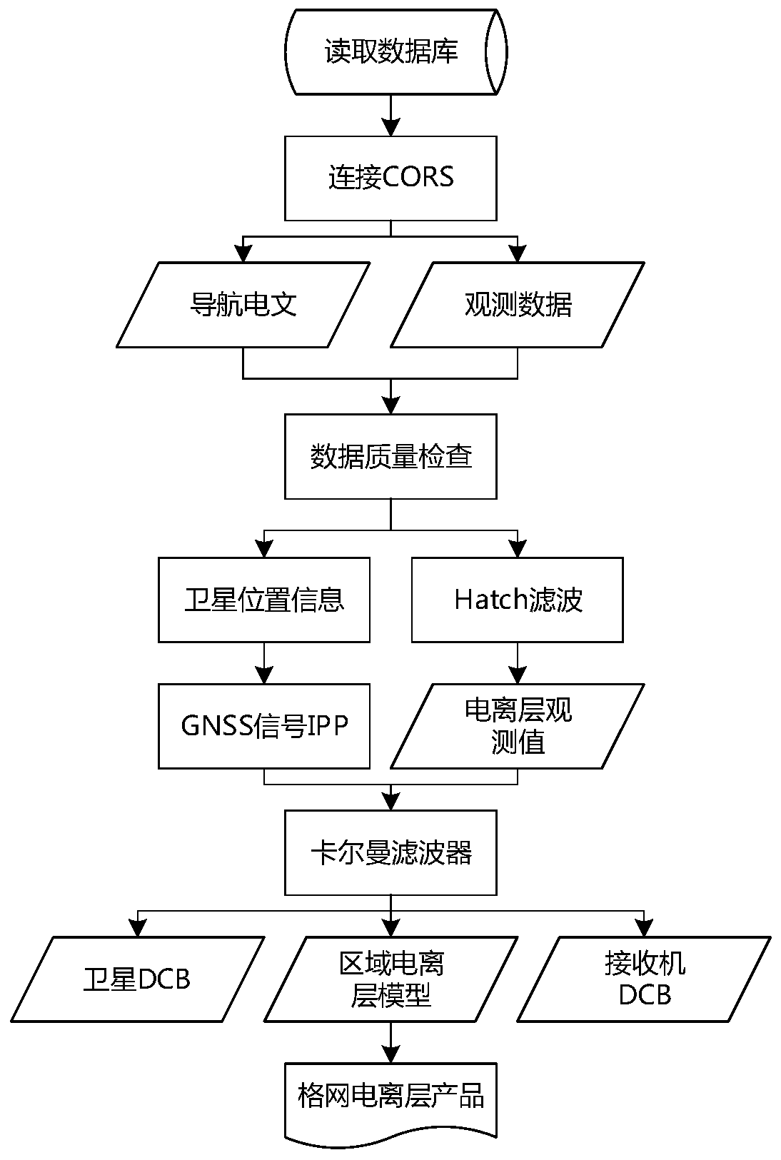
[0045] Such as figure 1 As shown, a real-time ionospheric modeling and monitoring method based on regional CORS disclosed in the embodiment of the present invention mainly includes the following steps:

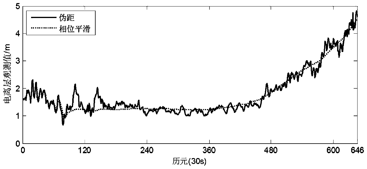
[0046] Step 1) Receive the original dual-frequency observation data and navigation message from the CORS station receiver in the area, and calculate the satellite position, altitude angle, and latitude and longitude of the puncture point after removing gross errors. Wherein when calculating the longitude and latitude of the piercing point, adopt the ionospheric monolayer model, assume that all free electrons in the ionosphere are all concentrated and distributed on an infinitely thin monolayer whose height is H, and get H=450km among the present invention. At this time, the position where the satellite signal passes through the ionosphere can ...


PUM


Abstract

The invention discloses a real-time ionosphere modeling and monitoring method based on a regional CORS (Continuous Operational Reference System). The method comprises the steps of: receiving originaldual-frequency observation data and a navigation message of a regional CORS station, rejecting a gross error, and then calculating a satellite position, an elevation angle and latitudes and longitudesof a puncture point; employing the Hatch filtering method and employing a carrier smooth pseudo-range observation value for differencing to obtain a TEC (Total Electron Contents) observation value without a geometric ionosphere; employing a spherical ion function to simulate the TEC distribution of the regional ionosphere, taking the model parameters and the satellite and the receiver differential code deviation as parameters to be estimated, constructing observation vectors by employing the observation data of all CORS stations of the single epoch to construct an observation equation; establishing a Kalman filter to perform real-time filtering processing for the parameters to be estimated, and separating from hardware delay to obtain an ionosphere TEC model; and finally, employing a model to calculate the grid point ionosphere delay, and storing and broadcasting the grid point ionosphere delay to regional users in a grid form. After an ionosphere product is obtained, a regional single-frequency PPP user location precision is obviously improved, and the dual-frequency PPP user convergence time is significantly improved.

Description

technical field [0001] The invention relates to a global navigation satellite system (Global Navigation Satellite System, GNSS) satellite positioning method, in particular to a real-time ionospheric modeling and monitoring method based on a continuous operation reference system (Continuous Operational Reference System, CORS). Background technique [0002] The ionosphere is an atmospheric region at a height of 60-2000 km from the ground. The thin air is ionized by ultraviolet rays and X-rays to generate a large number of free electrons, forming plasma, which can cause differences in electromagnetic signals passing through it, including reflection, refraction, scattering and absorption. degree of influence. Total Electron Contents (TEC) of the ionosphere is one of the most important parameters to describe the characteristics and changes of the ionosphere. Accurate acquisition of TEC information is essential for in-depth research on the physical characteristics and changes of t...

Claims


Application Information

Patent Timeline
Patent Type & Authority Applications(China)
IPC IPC(8): G01S19/07G01S19/41
Inventor 高成发张正协高旺潘树国尚睿赵涛
Owner SOUTHEAST UNIV
Why Eureka
Try Eureka