
electric power line patrol LiDAR data automatic registration method based on tower characteristic points

A technology of power line inspection and automatic registration, applied in the field of remote sensing, to reduce memory and time consumption, improve registration efficiency, and speed up the search effect

Active Publication Date: 2019-06-11
INST OF REMOTE SENSING & DIGITAL EARTH CHINESE ACADEMY OF SCI
View PDF10 Cites 13 Cited by
  • Summary
  • Abstract
  • Description
  • Claims
  • Application Information

AI Technical Summary

Problems solved by technology

[0005] The purpose of the present invention is to provide an automatic registration method for power line inspection LiDAR data based on tower feature points, which is mainly applicable to airborne laser radar data for power line inspection, solves the problem of unifying coordinates in the application of multi-temporal LiDAR data, and improves Registration efficiency and stability

Method used


Image

  • electric power line patrol LiDAR data automatic registration method based on tower characteristic points
  • electric power line patrol LiDAR data automatic registration method based on tower characteristic points
  • electric power line patrol LiDAR data automatic registration method based on tower characteristic points

Examples


Embodiment

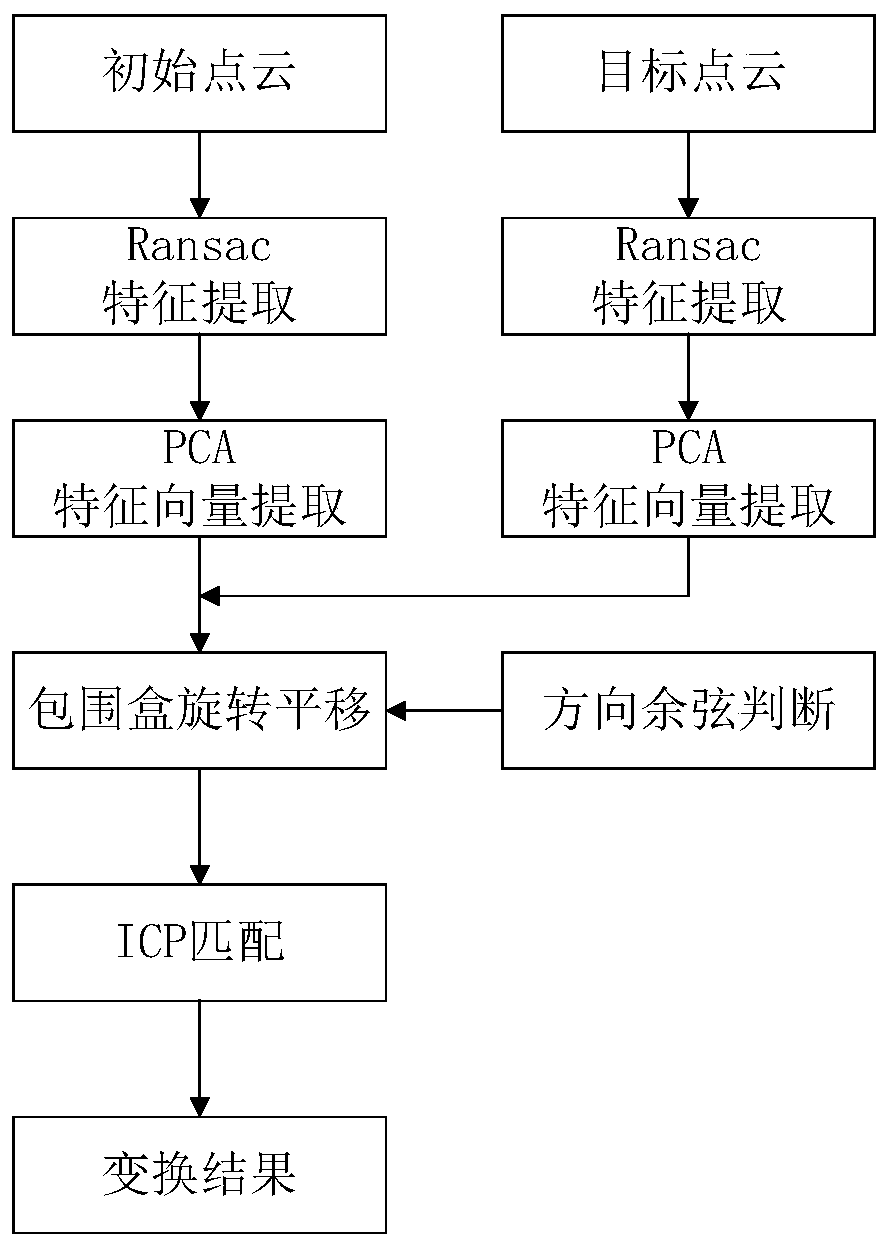
[0038] refer to figure 1 As shown, the present invention discloses a method for automatic registration of power line inspection LiDAR data based on tower feature points, comprising the following steps:

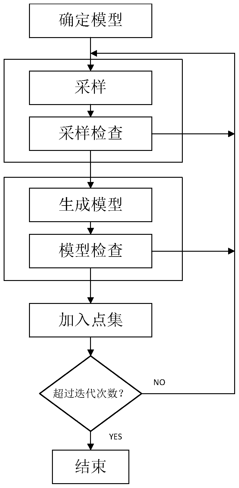
[0039] S1. For the power line inspection LiDAR data, the tower point clouds of the two phases of data were extracted respectively, and the random consistency algorithm (Ransac) was used to extract the characteristic point clouds of the edge lines and corners of the tower;

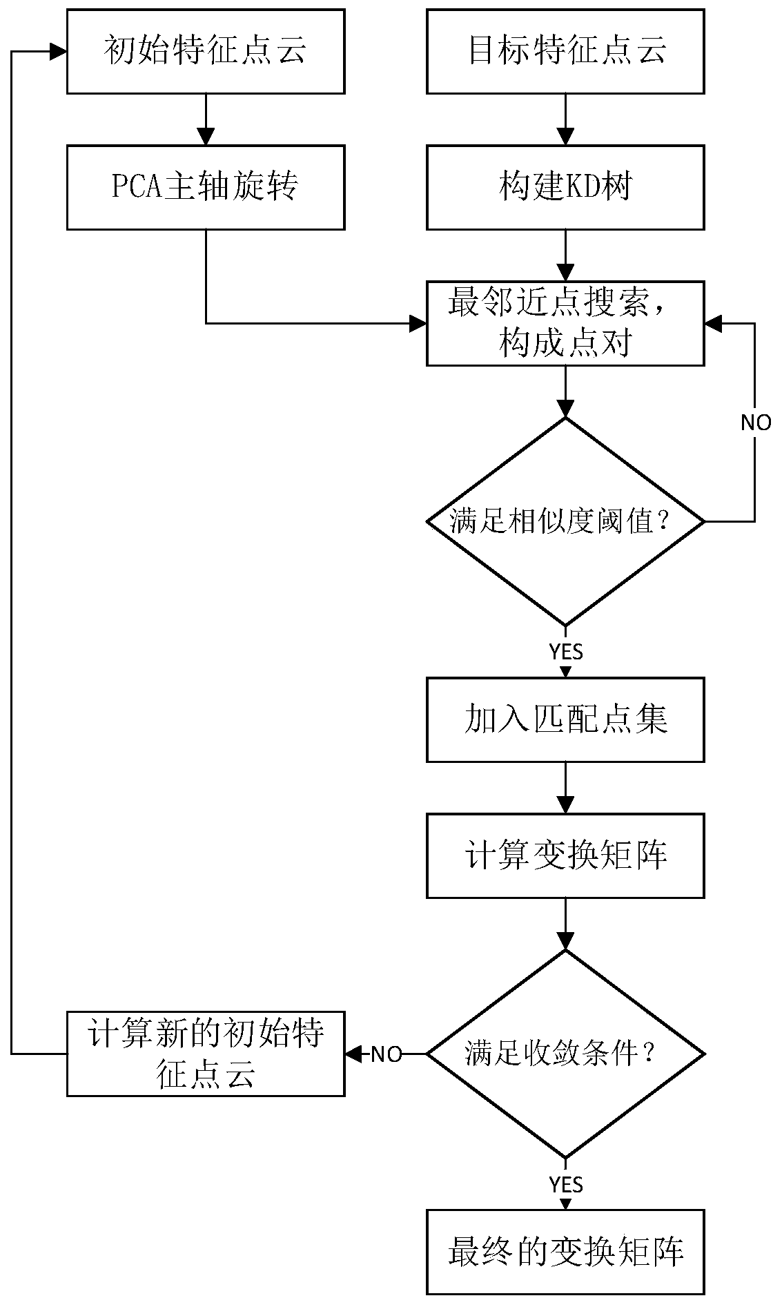
[0040] S2. Determine the centroids of the feature point sets of the two phases of towers, determine the corresponding relationship between the point cloud centroid coordinates of the two phases of towers based on the principal component analysis method and the direction cosine rule, and solve the initial transformation matrix;

[0041] S3. On the basis of the initial transformation, the iterative closest point algorithm (ICP) based on kd-tree optimized matching point search is used for fine matching to obta...


PUM


Abstract

The invention discloses an electric power line inspection LiDAR data automatic registration method based on tower characteristic points, and the method comprises the following steps: S1, extracting two stages of tower point cloud data, and extracting characteristic point clouds at corners of a tower through employing a random sampling consistency algorithm; S2, based on a principal component analysis method and a direction cosine rule, determining a corresponding relation between point cloud centroid coordinate systems of the two stages of towers, and solving an initial transformation matrix;S3, on the basis of initial transformation, adopting kd-based (kd-based) transformation; and carrying out fine matching on the tower characteristic points by using an iterative nearest point algorithmof tree optimized matching point search, obtaining a final transformation matrix, and carrying out spatial coordinate system conversion on the initial point cloud based on the target point cloud. According to the invention, under the condition that the electric power line inspection LiDAR data has data loss and lack of ground feature characteristics; The method comprises the following steps: extracting a tower area, extracting tower characteristic point cloud by utilizing a Ransac straight line fitting algorithm, calculating a transformation matrix by combining PCA coarse registration and ICPfine registration, and finally realizing transformation from an initial point cloud coordinate system to a target point cloud coordinate system.

Description

technical field [0001] The invention relates to the technical field of remote sensing, in particular to an automatic registration method for power line inspection LiDAR data based on tower feature points. Background technique [0002] High-voltage lines are an important part of the national backbone power grid, and the safety guarantee required for daily operation is getting higher and higher. Therefore, the measurement technology used in conventional power line inspection must have the characteristics of being able to obtain a large range of three-dimensional coordinates of the surface and high mathematical precision. [0003] Airborne LiDAR (Airborne Light Detection And Ranging, LiDAR) is an aeronautical earth observation sensor, which has the advantages of active observation, less affected by weather, certain penetration to ground object gaps, and direct acquisition of three-dimensional geometric information of the ground surface. . Use the airborne lidar technology to ...

Claims


Application Information

Patent Timeline
Patent Type & Authority Applications(China)
IPC IPC(8): G06T7/33G06K9/62
Inventor 王成习晓环刘洋聂胜
Owner INST OF REMOTE SENSING & DIGITAL EARTH CHINESE ACADEMY OF SCI
Learn More