
Stability monitoring system and evaluation method of high and steep bank slope based on microseismic technology

A monitoring system and micro-seismic technology, applied in seismic survey, seismology, geophysical survey, etc., can solve problems such as transmission mode, unclear acquisition parameters, and reduced monitoring accuracy, and achieve strong anti-interference ability, increased confidentiality, The effect of increasing effective utilization

Active Publication Date: 2019-09-10
CHONGQING INST OF GEOLOGY & MINERAL RESOURCES
View PDF11 Cites 11 Cited by
  • Summary
  • Abstract
  • Description
  • Claims
  • Application Information

AI Technical Summary

Problems solved by technology

This method uses 5 sensors, which is effective for the monitoring of small areas, but the monitoring accuracy for large areas will be reduced, and the transmission mode and acquisition parameters are not clear

Method used


Image

  • Stability monitoring system and evaluation method of high and steep bank slope based on microseismic technology
  • Stability monitoring system and evaluation method of high and steep bank slope based on microseismic technology
  • Stability monitoring system and evaluation method of high and steep bank slope based on microseismic technology

Examples


Embodiment 1

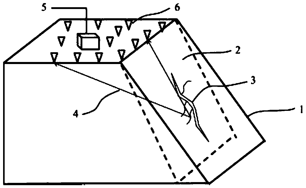
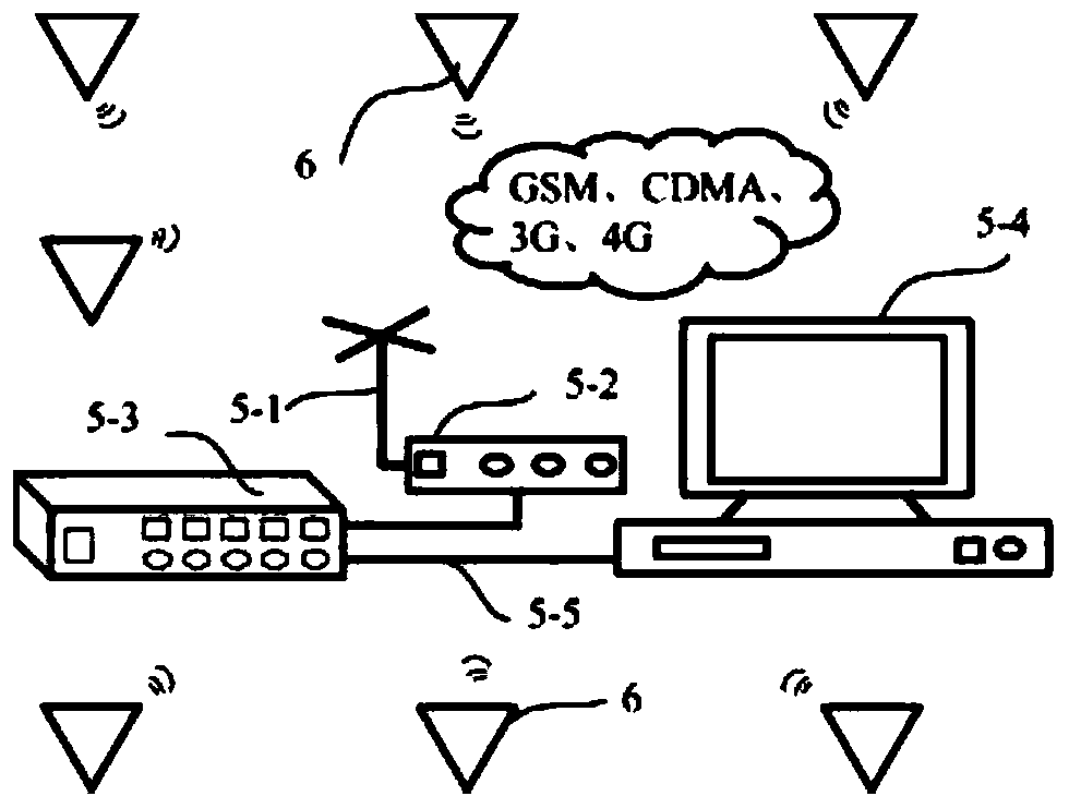
[0062] Such as figure 1 , figure 2 As shown, the present embodiment provides a high and steep bank slope stability monitoring system based on microseismic technology, including a data collection station 6 and a data processing and transmission center 5, and the data collection station 6 is arranged uniformly in a grid-like arrangement by several On both sides and the top of the landslide, the data processing and transmission center 5 is used to receive data from several data collection stations 6;

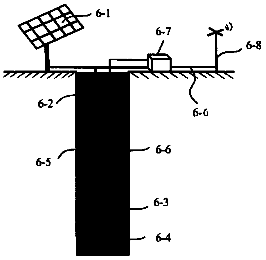
[0063] The data acquisition station 6 includes a geophone 6-3, a data acquisition instrument 6-7, and an acquisition end data transmission device 6-8. The geophone 6-3 is used to detect seismic wave signals, and the geophone 6-3 is placed by drilling In a hole 20-50 meters deep, ensure that the drilling depth is at least 6-4 meters deeper than the bedrock. The upper part is watered with cement slurry 6-5 until it is backfilled with soil 1 meter away from the wellhead, ensuring th...

Embodiment 2

[0072] This embodiment is optimized and defined on the basis of the above-mentioned embodiment 1.

[0073] In order to realize the power supply for the outdoor monitoring system, the data acquisition station 6 also includes a solar panel 6-1, and the solar panel 6-1 supplies power to the detector 6-3, the data acquisition instrument 6-7 and the data transmission equipment respectively.

[0074] The power line 6-2 output by the solar panel 6-1 supplies power to the detector 6-3, the data acquisition instrument 6-7 and the data transmission device 6-8 at the acquisition end respectively, and is connected through a double-shielded cable to avoid ground noise and voltage For the influence of noise on the detector 6-3, the solar panel 6-1 is respectively connected to the detector 6-3, the data acquisition instrument 6-7 and the data transmission device 6-8 at the acquisition end through double-shielded signal lines.

Embodiment 3

[0076] This embodiment is optimized and defined on the basis of the above-mentioned embodiment 2.

[0077] The geophone 6-3 adopts the three-component geophone 6-3, and the three-component geophone 6-3 adopts the three-channel acceleration sensor, the sensitivity is 250V / m / s, the dynamic range is 110dB, the sampling frequency can be set to 200Hz or 500Hz, and the frequency range 0.03Hz-100Hz.


PUM


Abstract

The invention relates to the technical field of monitoring and prevention of geological disasters, in particular to a stability monitoring system and evaluation method of a high and steep bank slope based on the microseismic technology. The stability monitoring system includes a geophone, a data collection instrument and collection end data transmission equipment, the geophone is used for detecting seismic wave signals and placed in a hole 20-50 meters deep in a drilling mode, and the geophone is connected with the data collection instrument outside the hole through a cable. According to the stability monitoring system and evaluation method of the high and steep bank slope, a regularization exiting mechanism is introduced into a long and short term memory model of an iterative neural network, complexity of computation in different hidden layer units is reduced, the stable state and development trend of the high and steep band slope can be comprehensively controlled in real time, the level of early warning and risk control of rock mass landslide is increased, strict data synchronous collection can be ensured, the rock mass condition can be also monitored reliably in real time, and the stability monitoring system and evaluation method have high engineering application value.

Description

technical field [0001] The invention relates to the technical field of monitoring and prevention of geological disasters, in particular to a high and steep slope stability monitoring system and monitoring method based on microseismic technology. Background technique [0002] The monitoring of rocky slopes has always been a weak link in the process of landslide monitoring and early warning. Existing conventional monitoring methods such as surface displacement, deep displacement, pore water pressure and rainfall monitoring methods are ineffective in response to rocky slope deformation monitoring and early warning and forecasting. There are deficiencies in the process. [0003] Chinese patent CN107015269 A discloses "A Real-time Monitoring System and Monitoring Method for Microseismic Fracturing Based on Wireless Network". The system is mainly composed of a server, a wireless microseismic data collection station, an on-site hand-held inspection terminal and a wireless AP. The s...

Claims


Application Information

Patent Timeline
IPC IPC(8): G01N29/12G01V1/00G01V1/22G01V1/28
CPCG01N29/12G01V1/288G01V1/223G01V1/001G01V1/282G01V1/01
Inventor 徐洪谢庆明陈立川刘洪陈柏林梁丹苏德桂廖蔚茗
Owner CHONGQING INST OF GEOLOGY & MINERAL RESOURCES
Learn More