Integration method of multi-source heterogeneous ecological space data

A technology of spatial data and integration methods, applied in the field of geophysical data information, can solve problems affecting decision-making quality, high operating costs, and format differences of collectors, etc., to improve integration and storage efficiency, increase drilling machine speed, increase speed and efficiency effect

Inactive Publication Date: 2019-10-18
重庆财经学院
View PDF8 Cites 1 Cited by
  • Summary
  • Abstract
  • Description
  • Claims
  • Application Information

AI Technical Summary

Problems solved by technology

[0002] With the continuous development of geological work in my country, after years of accumulation, my country has achieved important results in geological exploration, hydrological and petroleum geological surveys, and formed a huge geological data collection, including atlases, remote sensing image collections, and document collections. etc. These data occupy an important proportion in the results of spatial data. However, due to the differences in the format of the collectors, these data need to be converted when used, and the operation cost is relatively high. Since these data are the proof of our geological work over the years, they are the Further research on the important data basis of geological work has extremely important scientific research value. In order to meet the needs of people at different levels for geological information services, how to realize geological informationization has become a hot issue in the field of geology. A large number of geologists are doing their best. Promote the construction of geological-related information systems, establish a geological data platform, and complete the visualization of geological information
[0003] At present, geological data information is mainly based on the means of expression and comprehensive expression of geological data information based on GIS, but the lack of unification has seriously affected the scope and efficiency of geological data, and is not conducive to the discovery and mining of geological data information. Deeper content and knowledge, affecting decision quality
[0004] my country's geological data are mainly kept in paper form, and the degree of dataization is low. With the severe punishment of the number of years, the paper will be damaged, some texts and maps will gradually become blurred, and the geological information will be lost and cannot be used.
[0005] my country's geological data lacks a unified data model technology for unified management and expression of spatial data and attribute data, resulting in the inability of reasonable use and storage of data resources

Method used


Image

  • Integration method of multi-source heterogeneous ecological space data
  • Integration method of multi-source heterogeneous ecological space data
  • Integration method of multi-source heterogeneous ecological space data

Examples


Embodiment 1

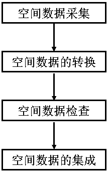
[0035] figure 1 A schematic flow chart of the multi-source heterogeneous spatial data integration method provided in this embodiment, as shown in figure 1 As shown, an integration method of multi-source heterogeneous ecological spatial data, including the following steps:

[0036] (1) Spatial data collection: input and check the spatial data, maps and attribute data according to the key fields in order to ensure the accuracy and reliability of the entered data;

[0037] (2) Spatial data conversion: Mapping is carried out under the same spatial reference datum, and the coordinates in different coordinate systems are converted into longitude and latitude coordinates of the geographic coordinate system;

[0038] (3) Spatial data inspection: including deduplication, merging, and deletion of data latitude and longitude coordinate inspection, file format conversion, etc., as well as data correctness, integrity, consistency inspection, etc.;

[0039](4) Integration of spatial data:...

Embodiment 2

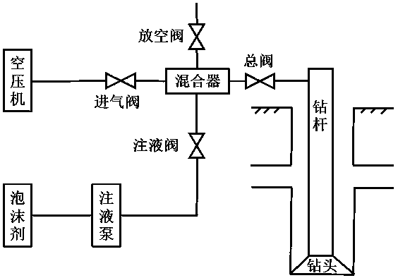
[0049] Considering the data characteristics of the integrated spatial data of coal mine geological resources in my country, they are mainly concentrated in arid and water-scarce areas. Conventional water circulation drilling technology cannot be carried out effectively and normally, and coal mines are prone to well deviations that are difficult to control during drilling work. In case of leakage, the air foam down-the-hole hammer drilling technology is used to drill coal mine resources, which can prevent the deviation of the drilling hole and increase the speed of the drilling machine.

[0050] Air foam down-the-hole hammer drilling process such as figure 2 As shown, the air foam DTH hammer drilling process is powered by compressed air, through the ground manifold and drill string, the DTH hammer is driven to break the rock by impact, and at the same time, the rotary table of the drilling rig rotates at a low speed, driving the drill bit to break the rock by shearing , and use...

Embodiment 3-6

[0053] Air foam preparation process is:

[0054] (1) The air foam is composed of 0.3% foaming agent, 0.03% foam stabilizer, and 0.01% anti-collapse agent;

[0055] (2) Wherein the foaming agent is a mixture of octadecyl glucoside and fatty alcohol polyoxyethylene ether sodium sulfate, the substance mass ratio is 1:1, add water and stir, wherein the addition ratio of foaming agent is 0.3%, and it is prepared into 200ml foaming Stir the foaming liquid at a rate of 5000r / min for 1.5min, and at the same time quickly pour the foam in the mixing cup into a graduated cylinder, and record the volume V of the foam in the cylinder 0 , when the volume to be precipitated is 100ml, record the required time t 0.5 ;

[0056] (3) The foam stabilizer is sodium carboxymethyl cellulose, first mix the foam stabilizer with water at a ratio of 1:300, stir at a rate of 5000r / min for 2min, and soak for 10h;

[0057] (4) The anti-slumping agent is cationic polyvinyl alcohol, and the addition ratio ...


PUM


Abstract

The invention discloses an integration method of multi-source heterogeneous ecological space data, which belongs to the technical field of geophysical data information, and comprises the following steps: spatial data acquisition: sequentially inputting and checking spatial data, maps and attribute data according to key fields to ensure the accuracy and reliability of the input data; conversion ofspatial data: performing mapping under the same spatial reference standard, and converting coordinates under different coordinate systems into longitude and latitude coordinates of a geographic coordinate system through coordinate conversion; spatial data inspection, including duplicate removal, combination, data longitude and latitude coordinate deletion inspection, file format conversion and thelike, and data correctness, integrity, consistency inspection and the like; integration of spatial data: gathering the spatial data into data information according to unified requirements and standards. According to the invention, scattered and heterogeneous data sources are integrated, integrated storage of coal mine geological data is realized, and the integration technology of storage efficiency is improved.

Description

technical field [0001] The invention belongs to the technical field of geophysical data information, and in particular relates to an integration method of multi-source heterogeneous ecological space data. Background technique [0002] With the continuous development of geological work in my country, after years of accumulation, my country has achieved important results in geological exploration, hydrological and petroleum geological surveys, and formed a huge geological data collection, including atlases, remote sensing image collections, and document collections. etc. These data occupy an important proportion in the results of spatial data. However, due to the differences in the format of the collectors, these data need to be converted when used, and the operation cost is relatively high. Since these data are the proof of our geological work over the years, they are the Further research on the important data basis of geological work has extremely important scientific research...

Claims


Application Information

Patent Timeline
Patent Type & Authority Applications(China)
IPC IPC(8): G06F16/25G06F16/28G06F16/29
CPCG06F16/258G06F16/284G06F16/29
Inventor 曾波李川周文浩
Owner 重庆财经学院
Why Eureka
Try Eureka