

Evaporation remote sensing inversion application based on reflectivity-vegetation coverage two-dimensional space
A technology for remote sensing of evapotranspiration and vegetation coverage, applied in instruments, biological neural network models, character and pattern recognition, etc., can solve the problems of poor intelligence, high server configuration, and large server memory occupancy, and achieve accurate surname high. Effect
- Summary
- Abstract
- Description
- Claims
- Application Information
AI Technical Summary
Problems solved by technology
Method used
Image

Examples
Embodiment 1
[0049] The application of remote sensing retrieval of evapotranspiration based on the albedo-vegetation coverage two-dimensional space, including:
[0050] S1. Construct evapotranspiration remote sensing inversion network based on convolutional neural network;
[0051]In this embodiment, the convolutional neural network includes an input layer, a convolutional layer, and a pooling layer. The number of convolutional layers is 16, the convolutional kernel size is 3*3, and the maximum pooling layer is 5. layer.
[0052] S2. Use training samples to train the evapotranspiration remote sensing inversion network; the training samples include satellite remote sensing images, meteorological data corresponding to satellite remote sensing image areas, and remote sensing short-wave infrared reflectance data.
[0053] In this embodiment, the evapotranspiration remote sensing inversion network obtains the evapotranspiration corresponding to the satellite remote sensing image area based on ...
Embodiment 2
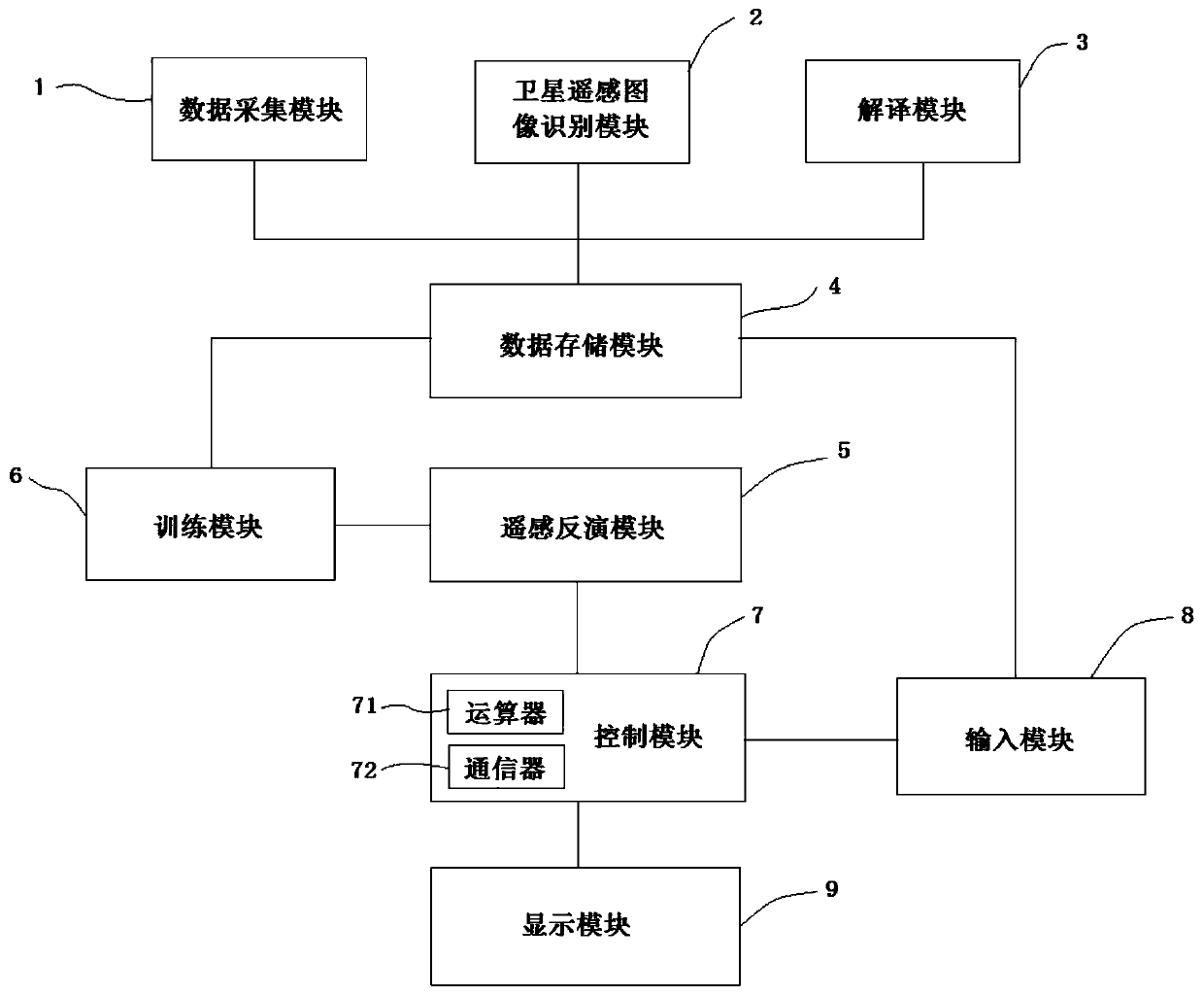
[0075] The evapotranspiration remote sensing retrieval device based on the albedo-vegetation coverage two-dimensional space, including:
[0076] Data collection module 1, is used for collecting the meteorological data of target area;
[0077] Satellite remote sensing image identification module 2, used to identify the satellite remote sensing image of the target area;
[0078] The interpretation module 3 is used to obtain reflectance data by interpreting the long-term sequence of remote sensing short-wave infrared reflectance data;
[0079] The data storage module 4 is connected with the data collection module 1, the satellite remote sensing image recognition module 2 and the interpretation module 3, and is used to store the meteorological data collected by the data collection module 1, the satellite remote sensing image of the target area identified by the satellite remote sensing image recognition module 2 and Interpretation module 3 interprets the obtained reflectance data...
PUM
 Abstract
Description
Claims
Application Information