Massive remote sensing data processing method and system based on distributed architecture

A technology of massive remote sensing data and distributed architecture, applied in image data processing, electrical digital data processing, special data processing applications, etc. Build speed, improve warehousing efficiency, fast storage and retrieval effect

Pending Publication Date: 2020-09-29
PEARL RIVER HYDRAULIC RES INST OF PEARL RIVER WATER RESOURCES COMMISSION
View PDF8 Cites 15 Cited by
  • Summary
  • Abstract
  • Description
  • Claims
  • Application Information

AI Technical Summary

Problems solved by technology

For example, the invention patent authorized and announced on June 8, 2016 is "A One-Stop Processing Method for Remote Sensing Data Requirements" and the authorized announcement number is CN 103559327B. It provides an integrated online data service, archived data call, The remote sensing data of data production scheduling and programming data service requires a one-stop processing method, but this method still adopts the traditional technical route, focusing on the rapid distribution of data, and does not consider the management and visualization of massive remote sensing data; on August 10, 2018 The invention name of the authorized announcement is "A Big Data Remote Sensing Satellite Data Processing System Based on Hadoop", and the authorized announcement number is CN 105045856B. It is mainly based on the Hadoop data platform to realize the distributed storage and management of remote sensing satellite data, but Without con

Method used


Image

  • Massive remote sensing data processing method and system based on distributed architecture
  • Massive remote sensing data processing method and system based on distributed architecture
  • Massive remote sensing data processing method and system based on distributed architecture

Examples


Embodiment

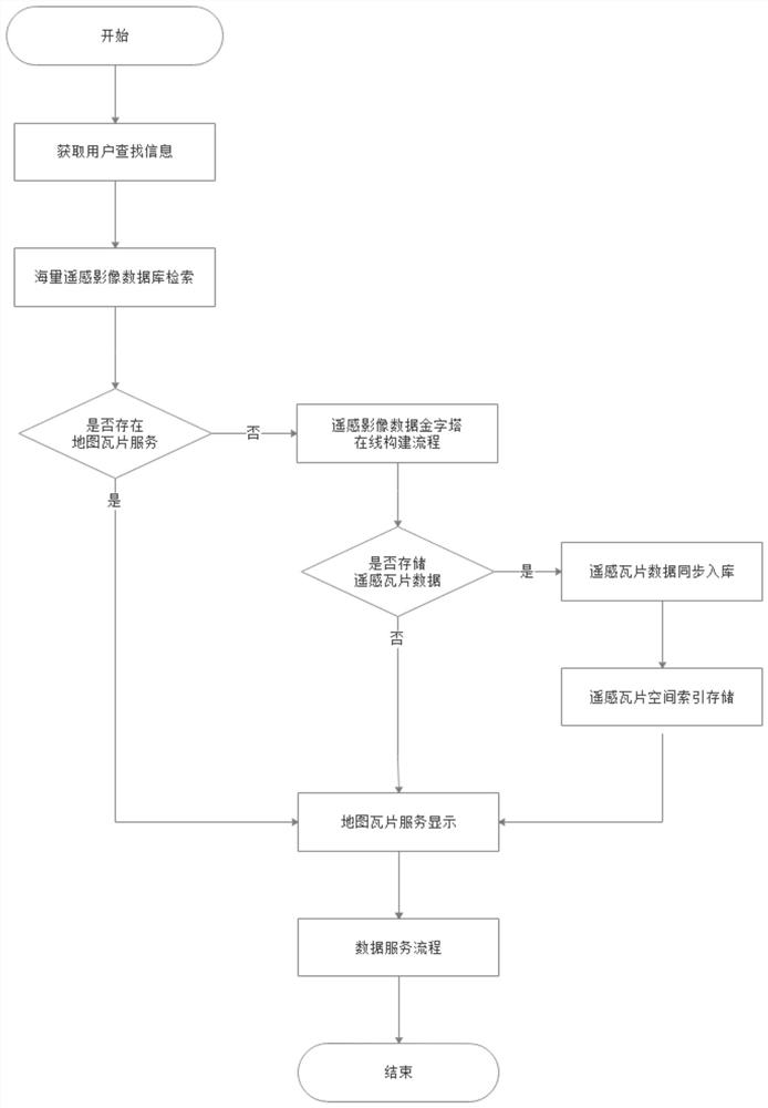
[0031] Such as figure 1 As shown, the present invention is based on the massive remote sensing data processing method of distributed framework, comprises the following steps:

[0032] S1. Through the remote sensing image data retrieval portal, obtain the information that the user needs to search, and obtain the user's retrieval conditions: the retrieval interface provided by the massive remote sensing data processing system provides text query, graphic query and other retrieval methods, mainly including: geographic scope , time phase, observation time, cloud cover, resolution, sensor type, etc., users can conduct comprehensive query and retrieval according to their own needs.

[0033] Among them, the massive remote sensing data processing system is realized through the comprehensive use of distributed file storage system HDFS, distributed framework Spark, distributed database MongoDB and other technologies.

[0034] S2. Retrieve the massive remote sensing image database: use ...


PUM


Abstract

The invention relates to the technical field of massive remote sensing application services, in particular to a massive remote sensing data processing method and system based on a distributed architecture. The method comprises the following steps: S1, acquiring information required to be searched; S2, carrying out massive remote sensing image database retrieval, if a retrieved remote sensing imagefile has no associated map tile service, turning to the step S3, and otherwise, turning to the step S6; S3, constructing a remote sensing image data pyramid online, if remote sensing tile data is selected to be stored and map tile service is issued, executing the step S4, and if remote sensing tile data is selected not to be stored, executing the step S6; S4, synchronously storing the remote sensing tile data; S5, performing remote sensing tile data spatial index storage; and S6, publishing and displaying the map tile service. Through the distributed architecture, the requirements of massiveremote sensing data storage, management, visualization and data service one-stop processing in the big data era are met.

Description

technical field [0001] The invention relates to the technical field of massive remote sensing application services, in particular to a method and system for processing massive remote sensing data based on a distributed architecture. Background technique [0002] With the increase of remote sensing data acquisition methods, remote sensing data gradually presents the characteristics of multi-source, multi-scale, and multi-time equalization. However, the explosive growth of data volume has led to a sharp increase in remote sensing data information that needs to be processed, resulting in scattered and disordered storage of massive remote sensing data. The emergence of problems such as insecure security and difficult data retrieval. Massive remote sensing data mainly composed of raster files cannot be quickly shared and directly used. However, the technology based on commercial software image service publishing has a low degree of automation, untimely service provision, and it i...

Claims


Application Information

Patent Timeline
IPC IPC(8): G06F16/51G06F16/53G06F16/27G06F16/538G06F16/182G06F9/48G06T5/00G06T5/40
CPCG06F16/51G06F16/53G06F16/27G06F16/538G06F16/182G06F9/4843G06T5/007G06T5/40Y02D10/00
Inventor 邹显勇田茂春赖杭范光伟何用余顺超杨跃
Owner PEARL RIVER HYDRAULIC RES INST OF PEARL RIVER WATER RESOURCES COMMISSION
Why Eureka
Try Eureka