Multi-stage vehicle-mounted laser point cloud road change monitoring method

A change monitoring, vehicle-mounted laser technology, applied in image data processing, still image data retrieval, special data processing applications, etc.

Pending Publication Date: 2021-02-05
RES INST OF HIGHWAY MINIST OF TRANSPORT +1
View PDF2 Cites 10 Cited by
  • Summary
  • Abstract
  • Description
  • Claims
  • Application Information

AI Technical Summary

Problems solved by technology

[0004] In the process of realizing the present invention, the inventor found that there is no road change detection method based on multi-period point clouds. The vehicle laser point cloud has complex scenes, various targets, large data volume and uneven distribution of point density. The vehicle laser point cloud data It is more difficult to register and monitor changes in

Method used


Image

  • Multi-stage vehicle-mounted laser point cloud road change monitoring method
  • Multi-stage vehicle-mounted laser point cloud road change monitoring method
  • Multi-stage vehicle-mounted laser point cloud road change monitoring method

Examples


Embodiment 1

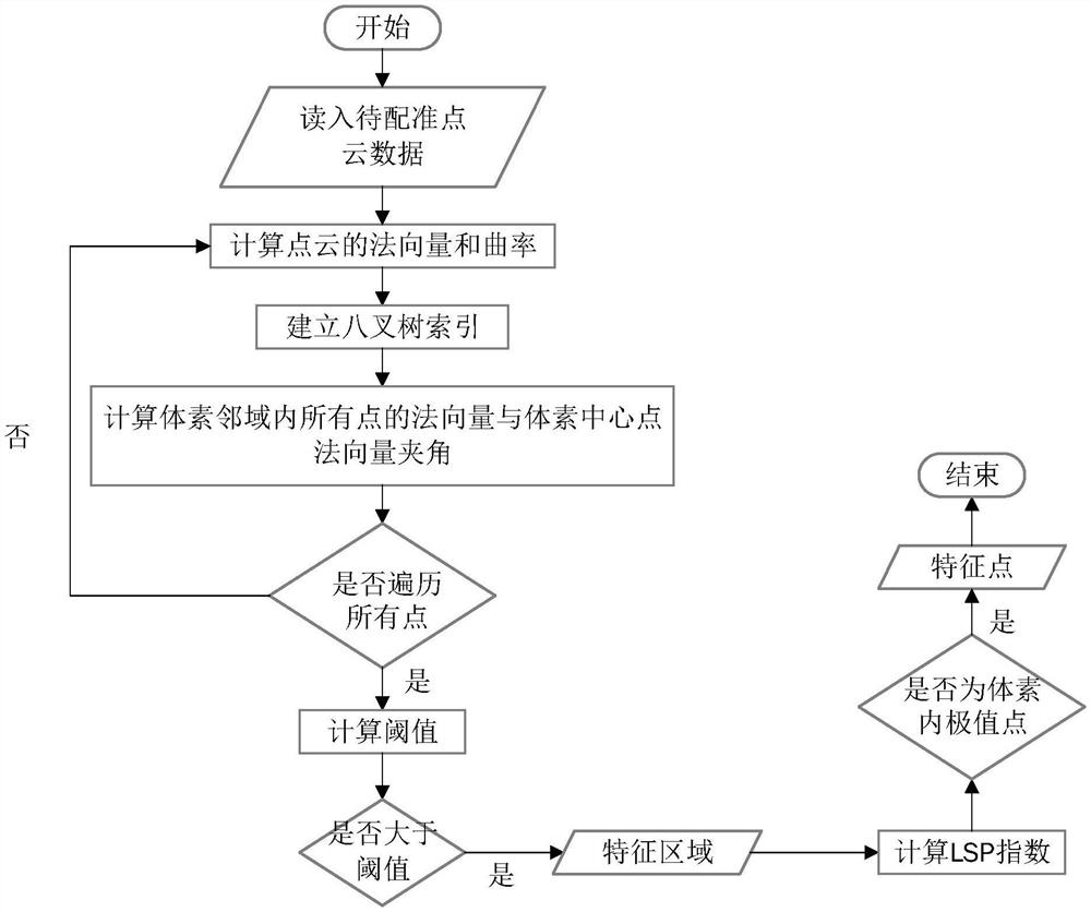
[0087] A multi-period vehicle-mounted laser point cloud road change monitoring method specifically includes the following steps:

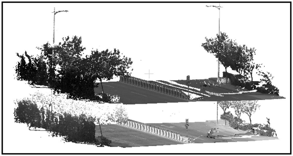
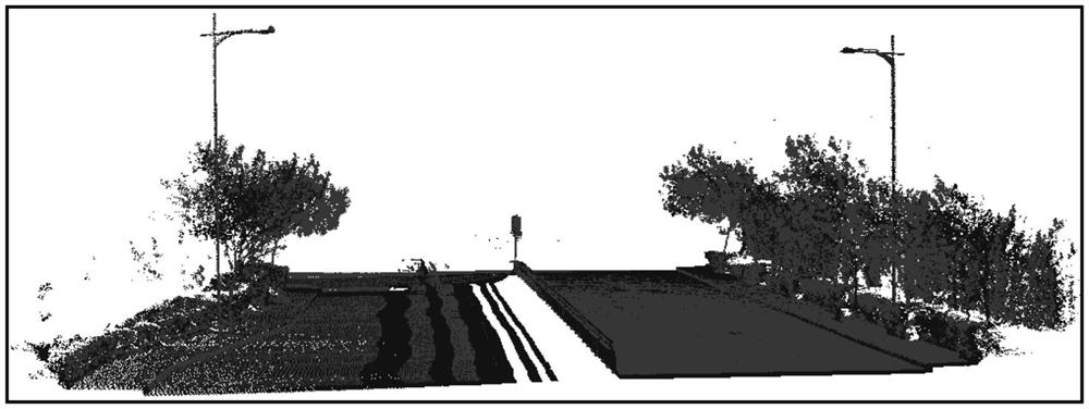
[0088] a. Select road point cloud data of different periods at the same location, and determine the road boundary based on the curb; use the cloth simulation algorithm to segment ground points and non-ground points, and keep non-ground points; delete non-rigid objects in non-ground points, Non-rigid objects include vehicles, pedestrians, green belts, vegetation, and street trees, and complete artificial features are extracted, including curbs, street lights, and traffic signs.

[0089] b. Calculate the normal vector of each point, obtain the average value of the sum of the angles between the normal vectors in the neighborhood at equal intervals, extract the feature area, and use the LSP feature point detection method to extract the points in the feature area Obtain evenly distributed and highly descriptive feature points for points with large fluct...


PUM


Abstract

The invention discloses a multi-stage vehicle-mounted laser point cloud road change monitoring method, which comprises the following steps of: firstly, analyzing the characteristics of a vehicle-mounted laser road point cloud, preprocessing road scene point cloud data into information and irrelevant information related to point cloud registration, further separating out a road surface point cloudby taking kerbs special for a road scene as boundary assistance, establishing an octree index based on a kerb boundary and ground object point cloud data, and extracting feature points at equal intervals by adopting a normal vector extraction feature region and an LSP (Local Surface Patches) feature detection method; and finally, using a 4PCS (4-Points Congruent Sets) registration algorithm basedon the feature points for completing coarse registration, and using an ICP (Iterative Closest Point) algorithm of a bidirectional KD tree index for completing fine registration. Change monitoring is performed on a road by taking the precision requirement of change monitoring as a constraint condition, so that the registration precision is higher and the registration speed is higher.

Description

technical field [0001] The invention relates to a multi-phase vehicle-mounted laser point cloud road change monitoring method, which belongs to the technical field of road detection of mobile measurement systems. Background technique [0002] Roads mainly include pavement, street trees, street lamps, guardrails, traffic lights, traffic signs and many other features, and the environment is complex; roads are the places with the largest traffic volume and the most frequent pedestrian activities in the urban environment. The abnormality of any element in the road system may affect the normal operation of the road. Therefore, it is necessary to monitor the changes of the road. [0003] The vehicle-mounted mobile measurement system can quickly and dynamically acquire high-precision, high-density, and high-resolution 3D laser point cloud data, providing data support for urban road information collection and update. [0004] In the process of realizing the present invention, the i...

Claims


Application Information

Patent Timeline
Patent Type & Authority Applications(China)
IPC IPC(8): G06T7/00G06T7/11G06T7/33G06F16/51
CPCG06T7/0002G06T7/11G06T7/337G06F16/51G06T2207/30252
Inventor 任红伟刘如飞卢秀山陈敏王飞柴永宁
Owner RES INST OF HIGHWAY MINIST OF TRANSPORT
Why Eureka
Try Eureka