Urban flood disaster dynamic assessment method based on multi-source data

A technique for dynamic assessment of flood disasters, applied in the field of assessment of flood disaster losses, dynamic assessment of impacts of flood disasters on population and traffic

Active Publication Date: 2021-05-18
CHINA INST OF WATER RESOURCES & HYDROPOWER RES
View PDF3 Cites 8 Cited by
  • Summary
  • Abstract
  • Description
  • Claims
  • Application Information

AI Technical Summary

Problems solved by technology

This type of method has certain limitations. In a given rainstorm scenario, no matter when the flood disaster occurs, the resulting loss is a constant value.

Method used


Image

  • Urban flood disaster dynamic assessment method based on multi-source data
  • Urban flood disaster dynamic assessment method based on multi-source data
  • Urban flood disaster dynamic assessment method based on multi-source data

Examples


Embodiment 1

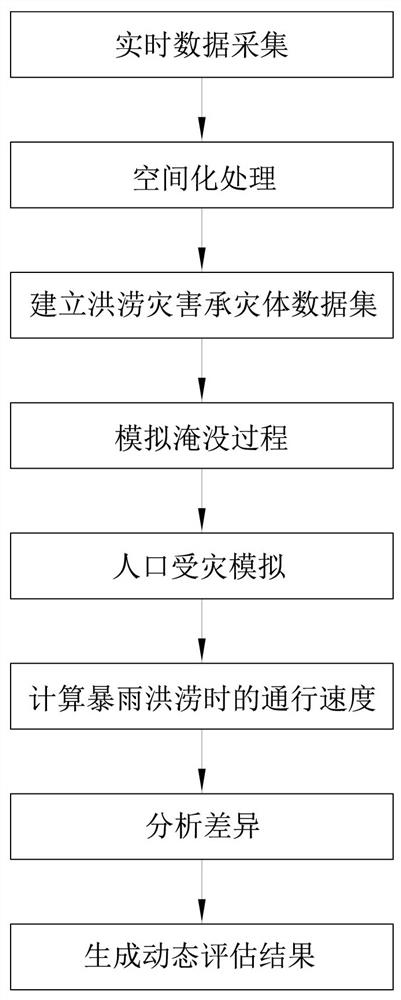
[0036] This embodiment is a method for dynamically evaluating urban flood disasters based on multi-source data. In order to realize the dynamic assessment in this embodiment, the first problem to be solved is the data acquisition of the disaster-affected body. The disadvantages of traditional data such as poor temporal and spatial resolution and difficult acquisition are restricting the development of dynamic assessment technology. With the wide application of big data technology and the rapid growth of data, the above problems have been effectively solved, and the dynamic assessment of flood disasters has been provided. It has also promoted the application of big data technology in the field of urban hydrology, and realized the interdisciplinary cross fusion. This embodiment uses web crawler technology to obtain the time and space change status of population and vehicles in real time from the digital map data of multiple digital map suppliers to form a data set, and then thro...

Embodiment 2

[0070] This embodiment is an improvement of Embodiment 1, and is a refinement of Step 3 in Embodiment 1. In this embodiment, the collection process of the population heat map data set described in step 3 includes the following sub-steps:

[0071] ①The mobile phone operating system simulator uses the http protocol debugging proxy tool to perform digital map data capture operations. For example, the Android emulator uses a proxy to connect to fiddler and perform operations. This acquisition process is mainly aimed at the operations in the mobile phone, so the mobile operating system is used as the object of explanation.

[0072] ② Analyze the data returned by the http protocol debugging proxy tool. The content of the analysis includes: obtaining the data cache files and index files in the APP, and filtering the data to be used.

[0073] ③Set the coordinates of the collection range, map zoom level and timing collection time.

[0074] Coordinates of the collection range: the c...

Embodiment 3

[0083] This embodiment is an improvement of the above embodiment, and is a refinement of step 3 of the above embodiment. The spatial distribution data set of the passing speed described in step 3 of this embodiment includes the following sub-steps:

[0084] 1. Road network acquisition: Open source map OSM data is used as the source of road data. Based on remote sensing image data and geographic information systems, such as ArcGIS tools, topology inspection is performed, and road traffic directions and connectivity are repaired to meet the requirements of research accuracy.

[0085] 2. Obtaining OD points (starting point-end point): According to the relevant attributes of open source map data, the roads in the research area are divided into 5 categories: expressway, first-class road, second-class road, third-class road and branch road, and use geographic information A system, such as an ArcGIS tool, obtains the latitude and longitude coordinates of the OD points of each road. ...


PUM


Abstract

The invention relates to an urban flood disaster dynamic assessment method based on multi-source data. The method comprises the following steps: collecting real-time data; carrying out spatialization processing; establishing a flood disaster affected body data set; simulating a submerging process; simulating population disaster; calculating the passing speed during rainstorm and flood; analyzing differences; and generating a dynamic evaluation result. According to the method, the superiority of a big data technology is fully utilized, urban population and traffic conditions are obtained based on a web crawler technology, and dynamic assessment of flood disaster loss is realized through the constructed disaster affected body data set and an urban rainfall flood model simulation result; the defects that traditional data are difficult to obtain and the temporal-spatial resolution is relatively poor are overcome, the cross research of the big data technology and the urban hydrological field is realized, the loss difference of disaster affected bodies at different flood occurrence time points can be captured, and the influence of flood disasters on the society can be truly reflected. The method can be combined with any urban rainfall flood model to guide disaster prevention and reduction work, and the toughness of a city is enhanced.

Description

technical field [0001] The invention relates to a dynamic evaluation method of urban flood disasters based on multi-source data, which is a method of digital calculation applied to hydrological calculation, an evaluation method of flood disaster losses, and a method of evaluating the impact of flood disasters on population and traffic. dynamic evaluation method. Background technique [0002] Affected by abnormal global climate changes and human social and economic activities, extreme precipitation events occur frequently, and flood disasters have become the most frequent natural disasters in the world. The high concentration of population and the high concentration of social and economic activities brought about by high urbanization have also increased the losses of flood disasters. Reasonable and effective assessment of flood disaster losses is of great significance for urban flood disaster early warning and forecasting, disaster management and other aspects. Most of the ...

Claims


Application Information

Patent Timeline
Patent Type & Authority Applications(China)
IPC IPC(8): G06Q10/06G06Q50/26
CPCG06Q10/0639G06Q50/26Y02A10/40
Inventor 邵薇薇苏鑫刘家宏杨志勇王开博陈宇枫
Owner CHINA INST OF WATER RESOURCES & HYDROPOWER RES
Why Eureka
Try Eureka