Method for rapidly and accurately collecting low-altitude remote sensing images based on unmanned aerial vehicle technology

A low-altitude remote sensing and unmanned aerial vehicle technology, which is applied in the direction of non-electric variable control, instruments, control/regulation systems, etc., can solve the problems of lack of satellite remote sensing images, driver fatigue, and large errors in positioning and measuring areas of satellite remote sensing images.

Inactive Publication Date: 2021-08-20
湖北无垠智探科技发展有限公司
View PDF7 Cites 4 Cited by
  • Summary
  • Abstract
  • Description
  • Claims
  • Application Information

AI Technical Summary

Problems solved by technology

[0009] 1. Large-scale satellite remote sensing images have large errors in positioning and measuring areas, and high-precision, high-time-efficiency satellite images are expensive to acquire;
[0010] 2. The lack of satellite remote sensing images in urban suburbs, rural areas, mountainous areas, etc., the manual acquisition cycle is long, the risk is high, and the economic cost is high;
[0011] 3. UAVs have limited energy and endurance, and a single flight cannot operate in a large area;
[0012] 4. In th

Method used


Image

  • Method for rapidly and accurately collecting low-altitude remote sensing images based on unmanned aerial vehicle technology
  • Method for rapidly and accurately collecting low-altitude remote sensing images based on unmanned aerial vehicle technology
  • Method for rapidly and accurately collecting low-altitude remote sensing images based on unmanned aerial vehicle technology

Examples


Embodiment 1

[0106] A piece of geomorphic data with an orthographic area of ​​about 9 mu was collected in a mountainous area. In remote mountainous areas, AutoNavi, Baidu, Tencent, Tiantu, etc. do not have high-resolution satellite remote sensing images and vector map data in the area. Collect data according to the following procedure.

[0107] 1. Turn on the drone and the remote controller of the drone.

[0108] 2. Fly the UAV at a certain height, so that the pre-acquisition area is in the interface of the UAV's gimbal camera, which is assumed to be 50m here.

[0109] 3. Click Generate Route, the software will automatically generate the route, the specific calculation is as follows:

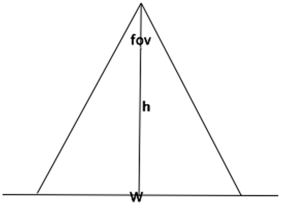
[0110] (1) First calculate the size of the actual area imaged by the UAV at a height of 50m,

[0111] Width W = 2*tan(84 / 2)*50 ≈90.04,

[0112] Image height H = 3*W / 4=67.53,

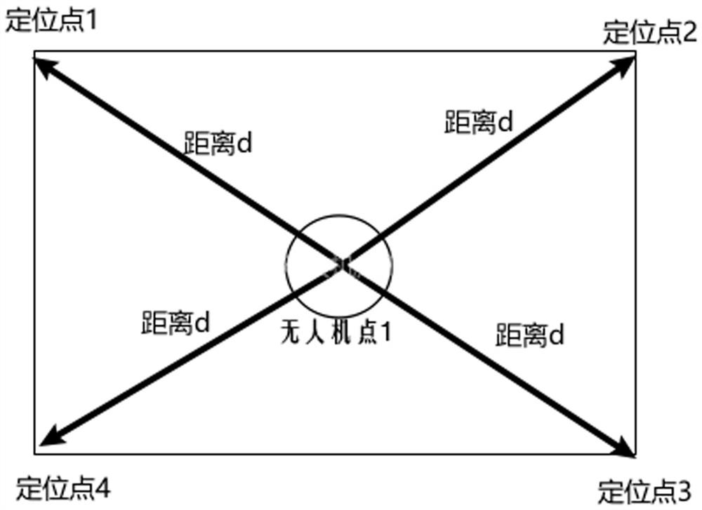
[0113] Distance from four anchor points ≈112.55,

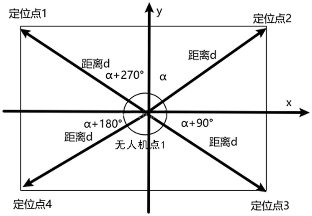
[0114] phase angle =23.57°;

[0115] (2) Then calculate the latitude a...

Embodiment 2

[0135] Collect data of an agricultural water conservancy project with an orthographic area of ​​about 36 mu in a mountainous area. In remote mountainous areas, AutoNavi, Baidu, Tencent, Tiantu, etc. do not have high-resolution satellite remote sensing images and vector map data in the area. Collect data according to the following procedure.

[0136] 1. Turn on the drone and the remote controller of the drone.

[0137] 2. Fly the UAV at a certain height, so that the pre-acquisition area is in the interface of the UAV's gimbal camera, which is assumed to be 100m here.

[0138] 3. Click Generate Route, the software will automatically generate the route, the specific calculation is as follows:

[0139] (1) First calculate the size of the actual area imaged by the UAV at a height of 100m,

[0140] Width W = 2*tan(84 / 2)*100 ≈180.08,

[0141] Image height H = 3*W / 4=135.06,

[0142] Distance from four anchor points ≈225.1,

[0143] phase angle =23.57°,

[0144] (2) Then cal...


PUM


Abstract

The invention belongs to the technical field of unmanned aerial vehicle aerial photography collection, and particularly relates to a method for rapidly and accurately collecting low-altitude remote sensing images based on an unmanned aerial vehicle technology, the unmanned aerial vehicle flies to a certain height, a camera vertically faces the ground, and the imaging range of the camera completely covers a target area, namely a collection area range; the width of the imaging range is calculated through the flight height of the unmanned aerial vehicle and the wide angle of the camera, and the length of the imaging range is calculated through the width-to-length ratio of the camera; longitudes and latitudes of four vertexes of an imaging range are calculated according to the longitudes and latitudes of a current GPS positioning point of the unmanned aerial vehicle, and a target area is determined; and a task route of the unmanned aerial vehicle is planned according to the target area, wherein the unmanned aerial vehicle flies according to the task route to complete the aerial photography task. The method is mainly used for solving the problems of how to quickly, accurately and automatically complete route planning of a target area and how to integrally and automatically collect orthoimages under the condition that no available satellite remote sensing image data exists or the satellite remote sensing image data is invalid in the aerial photography activity of the unmanned aerial vehicle.

Description

technical field [0001] The invention belongs to the field of unmanned aerial vehicle aerial photography acquisition technology, and specifically designs a method for quickly and accurately collecting low-altitude remote sensing images based on unmanned aerial vehicle technology. Background technique [0002] At present, UAV aerial photography technology is widely used in surveying and mapping exploration, land resources, power inspection, precision agriculture and other industries. UAV aerial photography collection should include UAV system, APP flight control system, central image processing system, map layer service system, streaming media service system, and image storage system. Among them, the APP flight control system is the key point. Common APP flight control systems generally include: [0003] The task management module is used for remote synchronization of aerial photography tasks, management operations such as creating, saving, and loading aerial photography task...

Claims


Application Information

Patent Timeline
IPC IPC(8): G05D1/10
CPCG05D1/106
Inventor 余诗凡张云涛左壮
Owner 湖北无垠智探科技发展有限公司
Why Eureka
Try Eureka