
Emitted long wave radiation calculation method suitable for AGRI instrument on FY4A satellite

A technology of long-wave radiation and calculation methods, which is applied in the field of OLR calculation of meteorological satellites, can solve the problems of low inversion accuracy and difficult to reflect the influence of radiation amount, etc., and achieves high inversion accuracy, strong generalizability, and large application range. Effect

Pending Publication Date: 2021-09-03
NAT SATELLITE METEOROLOGICAL CENT
View PDF0 Cites 1 Cited by
  • Summary
  • Abstract
  • Description
  • Claims
  • Application Information

AI Technical Summary

Problems solved by technology

[0003] However, in the current satellite inversion algorithm, different band combinations are considered to establish the inversion algorithm. Since each channel reflects the characteristics of different properties of the surface or the atmosphere, only by selecting the appropriate combination of infrared channels can a reasonable calculation result be obtained, which has great significance. In addition, it is difficult to reflect the influence of near-surface gas and water vapor on radiation, and the inversion accuracy is not high

Method used


Image

  • Emitted long wave radiation calculation method suitable for AGRI instrument on FY4A satellite
  • Emitted long wave radiation calculation method suitable for AGRI instrument on FY4A satellite
  • Emitted long wave radiation calculation method suitable for AGRI instrument on FY4A satellite

Examples


Embodiment 1

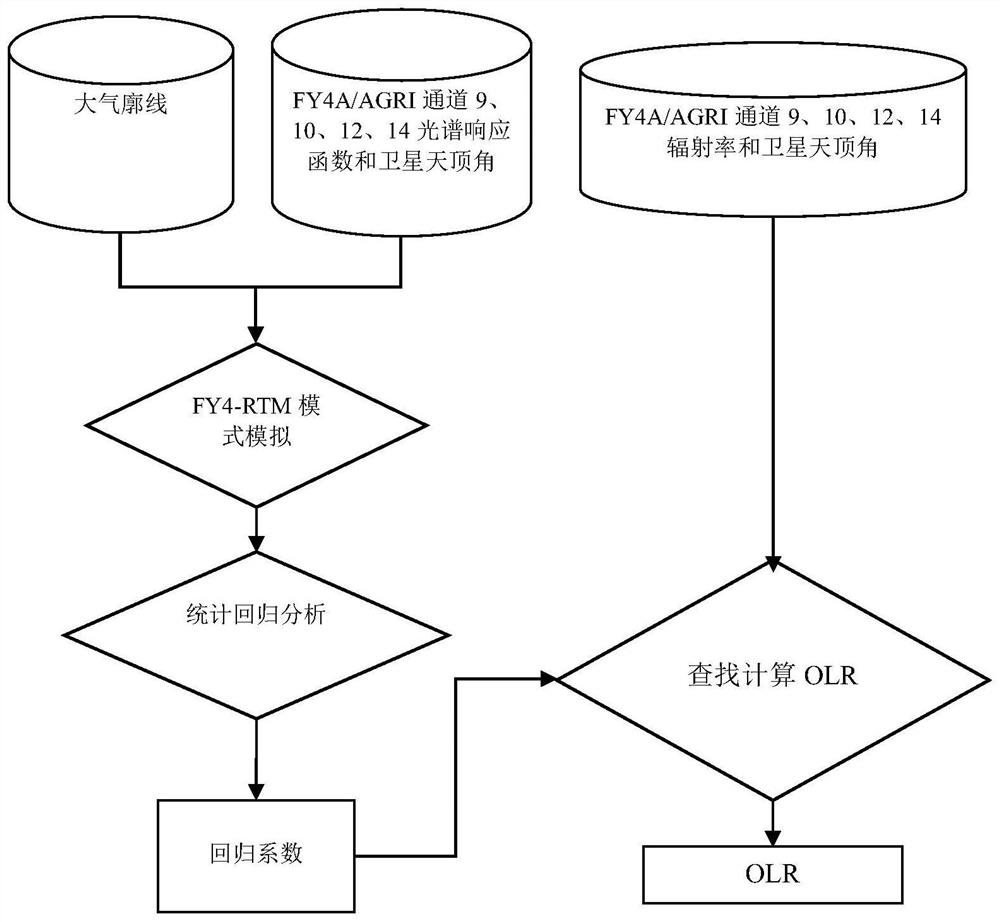
[0035] This embodiment provides a specific structure adapted to the calculation method of the emitted long-wave radiation of the AGRI instrument on the FY4A satellite, such as figure 1 shown, including the following steps:

[0036] Read in IMAGER observation data;

[0037] FY4-RTM mode simulation;

[0038] Statistical regression analysis, deriving regression coefficients;

[0039] Calculate the OLR of long-wave radiation emitted from the top of the atmosphere.

[0040] Specifically, IMAGER observation data include AGRI channel radiance, satellite zenith angle.

[0041] Specifically, the AGRI channel includes channel 9, channel 10, channel 12, channel 14 and water vapor channel.

[0042] Specifically, the FY4-RTM model simulation includes: based on the atmospheric profile, the AGRI channel spectral response function and the satellite zenith angle, using the FY4-RTM software to calculate the simulated long-wave radiation rate emitted from the top of the atmosphere, the calcu...

Embodiment 2

[0059]This example gives a verification method for the calculation method of the emitted long-wave radiation of the AGRI instrument on the FY4A satellite. Usually, we illustrate the accuracy of product quality by comparing with foreign similar high-precision satellite data, and use this technology to process FY4A / AGRI level 1 data obtained OLR products, compared with the instantaneous OLR of the Aqua satellite CERES instrument, the RMSE is between 8-11W / m2, and the uniform underlying surface is between 3-6W / m2, FY4A / AGRI and HIRSCDR Compared with the average OLR, the RMSE is between 6-8W / m2; compared with the average OLR of FY4A and HIRSCDR, the RMSE is between 4-6W / m2; compared with the ten-day average OLR of FY4A and HIRSCDR, the RMSE is between 4-5W / m2; Compared with the monthly average OLR of FY4A and HIRSCDR, the RMSE is between 3-4W / m2. These verification results prove that this method is suitable for calculating the emitted long-wave radiation products from FY4A / AGRI da...


PUM


Abstract

The invention discloses an emitted long wave radiation calculation method suitable for an AGRI instrument on an FY4A satellite. The emitted long wave radiation calculation method comprises the following steps of reading in IMAGER observation data; carrying out FY4-RTM mode simulation; carrying out statistical regression analysis, and exporting a regression coefficient; and calculating the long-wave radiation OLR emitted by the atmosphere top. The invention is suitable for the technical field of OLR calculation of meteorological satellites, OLR inversion is carried out by adopting multi-channel data, the influence of near-surface gas and water vapor on the radiation quantity can be better reflected, and the inversion precision is higher; meanwhile, channel information used in the method has extremely high correlation with OLR, by establishing a regression relation between satellite channel observation and OLR simulation, the atmospheric ejection long wave radiation flux-OLR is calculated according to the satellite channel radiance, limitation of an existing method is overcome, higher precision is obtained, meanwhile, the invention has a larger application range, and generalizability is high.

Description

technical field [0001] The invention belongs to the technical field of OLR calculation of meteorological satellites, in particular to a method for calculating emitted long-wave radiation adapted to the AGRI instrument on the FY4A satellite. Background technique [0002] The long-wave radiation emitted by the top of the atmosphere, referred to as OLR, is the heat radiation flux density radiated from the earth's atmosphere system to outer space, and is one of the important parameters of the energy balance of the earth's atmosphere radiation. The spatial and temporal distribution of OLR observed by satellites can reflect the thermal In clear areas, the size of OLR is closely related to the surface emission; while in cloudy areas, OLR is related to cloud top temperature, and high cloud cover often corresponds to a lower OLR value. Therefore, OLR data retrieved by satellites can be used to study tropical convection and precipitation estimates, ENSO, ITCZ, monsoon, etc.; [0003]...

Claims


Application Information

Patent Timeline
Patent Type & Authority Applications(China)
IPC IPC(8): G06F30/20G06F17/18
CPCG06F30/20G06F17/18
Inventor 张婉春吴晓白文广张鹏孙凌刘健
Owner NAT SATELLITE METEOROLOGICAL CENT
Learn More