Hyperspectral monitoring and GIS coupled mountain torrent disaster dynamic risk assessment method

A dynamic risk and risk assessment system technology, applied in the field of mountain torrent disaster monitoring and risk assessment, can solve the problem of information update lag, inability to accurately judge the risk level of mountain torrents in different regions, and incompletely giving the risk, vulnerability and risk level of mountain torrents Level and other issues to achieve the effect of accuracy

Active Publication Date: 2021-10-08
CHANGJIANG RIVER SCI RES INST CHANGJIANG WATER RESOURCES COMMISSION
View PDF4 Cites 6 Cited by
  • Summary
  • Abstract
  • Description
  • Claims
  • Application Information

AI Technical Summary

Problems solved by technology

However, the objects of all these evaluations are often single disasters such as mudslides, landslides, or simple river floods, and the evaluation units are basically based on administrative regions, lacking in systematization of river basins and completeness of disasters, and the selection of evaluation indicators is also incomparable
Secondly, the current results of large-scale mountain torrent disaster zoning are basically a black box model, which does not fully give the risk, vulnerability and risk level of each mountain torrent gully, so it is impossible to accurately judge the risk level of mountain torrents in different regions
Furthermore, the information update of various carriers lags behind, and the flexibility of the mountain torrent disaster monitoring system is poor
In particular, due to the shortcomings of monitoring technology, the information of environmental risk factors in mountain torrent disaster-prone areas has changed, which cannot be reflected in the evaluation indicators in a timely and accurate manner.
The investigation of key hidden dangers is relatively difficult, and the emergency response and processing capabilities are not enough

Method used


Image

  • Hyperspectral monitoring and GIS coupled mountain torrent disaster dynamic risk assessment method
  • Hyperspectral monitoring and GIS coupled mountain torrent disaster dynamic risk assessment method
  • Hyperspectral monitoring and GIS coupled mountain torrent disaster dynamic risk assessment method

Examples


Embodiment

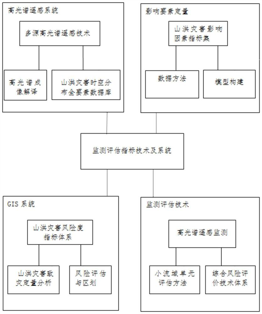
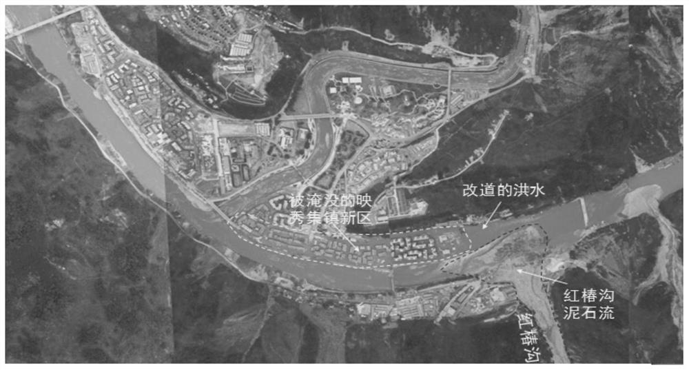
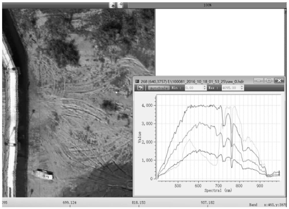
[0075] Taking the application of the present invention in a certain earthquake province as an example, the present invention will be described in detail in conjunction with the accompanying drawings, but they do not constitute a limitation of the present invention, and are only examples. At the same time, the advantages of the present invention are clearer and easier to understand through the description. This embodiment also has guiding significance for the application of the present invention in other areas to rapid hyperspectral remote sensing monitoring in mountain torrent disaster-prone areas, and the use of multi-temporal and spatial torrent disaster dynamic risk monitoring and evaluation based on small watershed units.

[0076] This embodiment includes the following steps:

[0077] Step 1: Basic data collection

[0078] Based on the needs of mountain torrent disaster risk assessment in a province where mountain torrent disasters are prone to occur, a basic geographic i...


PUM


Abstract

The invention discloses a hyperspectral monitoring and GIS coupled mountain torrent disaster dynamic risk assessment method. The method comprises the following steps of: step 1, constructing a hyperspectral remote sensing technology application system; 2, extracting mountain torrent disaster related information; 3, simulating evolution and disaster forming processes of a single disaster type and a composite disaster type; 4, constructing a stepwise regression equation; 5, determining an index system of a mountain torrent disaster risk degree; 6, obtaining a mountain torrent disaster risk map and a mountain torrent disaster vulnerability result map; 7, performing normalization to obtain a multi-spatial-scale mountain torrent disaster risk map; and 8, dividing a mountain torrent disaster risk region of a specific region. The method has the advantage of realizing the accuracy, reliability and timeliness of the basic data information of a mountain torrent disaster susceptible area.

Description

technical field [0001] The invention relates to the technical field of mountain torrent disaster monitoring risk assessment, more specifically, it is a dynamic risk assessment index method for mountain torrent disasters coupled with hyperspectral monitoring and GIS methods. Background technique [0002] my country is one of the countries with the most serious natural disasters in the world. There are many types of disasters, wide distribution areas, high frequency of occurrence, and heavy losses. Among the many disasters, mountain torrents and their secondary derivative disasters are the most serious disasters faced every year. As of the end of 2019, a total of more than 40 billion yuan has been invested in project construction across the country. A mountain torrent disaster monitoring and early warning system and a group monitoring and group prevention system suitable for my country's national conditions have been initially established, and the disaster prevention and miti...

Claims


Application Information

Patent Timeline
Patent Type & Authority Applications(China)
IPC IPC(8): G06Q10/06G06F16/29G06Q50/26
CPCG06Q10/0635G06F16/29G06Q50/26Y02A10/40
Inventor 师哲任洪玉丁文峰杜俊赵元凌邹翔蔡道明牛俊江民杨晶邓灵敏汪倩
Owner CHANGJIANG RIVER SCI RES INST CHANGJIANG WATER RESOURCES COMMISSION
Why Eureka
Try Eureka